Category Archives: Tennessee

20231201-02_Returning-Home

Note:  This post contains two (2) photos near the end.  Both were taken by me (Bruce) with a Google Pixel 6 Pro.


FRIDAY 01 December 2023 — Another travel day

Our trip last month from home to Luxury RV Resort in Gulf Shores, Alabama in October was around 1,400 miles and took 15 days because of our transit of the Natchez Trace National Parkway (NTNP).  The trip in the other direction was estimated at around 1,050 miles and a little over 14-hours driving time.  A shorter distance, for sure, as it would be more direct and we were not planning our route to include any special sites along the way.  Still, that would be an average daily driving distance of about 265 miles for each of the four travel days we planned for the trip, with a total driving time of 21 hours for an average 5 hours per day.  Our trip yesterday, however, was only 223 miles, so we still had 827 miles to travel over three days, or about 275 miles per day.  That was still within the 150 – 300 miles per day target that seems to work well for us.  In spite of cold temperatures, which would require us to quickly winterize the travel trailer once we got home, we were nonetheless eager to get there.

Our next overnight stop was the Grand Ole RV Resort in Goodlettsville, Tennessee, a place we have stayed several times, including at the beginning of our drive down the NTNP.  We like this RV park, and find it convenient when RVing up and down I-65 through Kentucky and Tennessee.  Our mapping/routing apps indicated a 256-mile drive which we estimated to be about 5 hours driving time at our estimated average speed of 50 MPH.

Check-in at RV parks is generally sometime after noon, but can be as late as 3 PM.  A call to the resort confirmed that we could arrive and check-in sooner than that.  I suspect, but I do not recall, that we broke camp and were on our way between 9 and 9:30 AM and arrived between 2 and 2:30 PM.  As best I recall (ABIR), the weather was nice when we arrived, which gave us plenty of time to leisurely “make camp,” and then go for a walk around the RV park.  We then detached the truck from the travel trailer and went in search of food and fuel.  I do not recall what the weather was like during the evening and over-night hours, but if we had storms (which can be fierce in this area) they must not have been too bad as we were not awakened and our truck/trailer did not have any damage.


SATURDAY 02 December 2023 — A minor technical issue, and home at last

As mentioned above, when we left Luxury RV Resort in Gulf Shores, Alabama on 30 November, we intended to take four days to make the trip home, stopping for three nights along the way, and arriving home on Sunday, December 3rd.  Indeed, Linda had made a reservation for each of the three nights.  ABIR these many months later, our last and final stop was booked at the Lebanon / Cincinnati NE KOA northeast of Cincinnati, Ohio and east of I-75, another KOA where we have stopped in the past.  The distance for this leg was approximately 300 miles, with a time estimate a little over 4 hours, which we figured would be closer to 6 hours.  (We use KOAs because when they are convenient to our route as it is easy to book online and easy to cancel with little or no penalty.)

One of the issues for us, when towing the travel trailer, is that the fuel economy of the F-150 / trailer combination usually averages around 12 MPG.  This is about 60% – 50% of the 20 – 24 MPG we can get from the truck during extended highway travel without the trailer.  We have a 36-gallon fuel tank so, hypothetically we can travel 432 miles before running out of gasoline, but we do not like the run the tank below the 1/4 mark if possible.  As a practical cutoff, as we approach the 300-mile mark of a leg we start to incur additional travel time because we have to stop for fuel before reaching our destination.  That also means trying to find a filling station that we can get into, position the rig for good access to a pump, and exit without getting stuck or damaging the trailer.  Yeah, we worry about things like that.  (Our preferred routine is to get to our campsite, set up camp, and then disconnect the truck and go find fuel.)  Fuel economy combines with other factors to determine a realistic ETA such as:  a) the time required to exit an RV park and make our way on surface streets to the highway we plan to travel, and b) the fact that we tend to drive at 62 MPH on highways posted at 65 or 70 MPH.  Basing our ETAs on that average speed has worked remarkably well for us.

Our only technical mishap of the entire trip (with the trailer) happened this morning.  Everything was going according to our usual routine for breaking camp and packing up.  When I tried to unplug the “50A RV” shorepower cord from the socket end of the Hughes Power Watchdog EPO surge/transient protector device, however, the ground pin on the cord broke off and remained lodged in the Power Watchdog.  The ground pin turned out to be potted metal surrounded by brass, and was much weaker by design that I would have expected.  Also, the plug was molded so, given these two facts, there was no chance of being able to do a field repair on this expensive piece of junk.

We did not have a spare “50 A” cord with us, as they are just too bulky and heavy to carry a second one.  (We always had a spare in the converted motorcoach, but we have the space and load capacity for that.)  We also did not want to try and buy a new one as they are expensive, the RV park store was unlikely to have (a good) one much less at a bargain price, and we did not want to take the time to go find one somewhere else.  We did have a “15 A” cord that was sufficient to run the lights (LED) and control circuits for the refrigerator, hot water heater, and furnace, which would allow us to use propane as the heat source, but because we were moving into an area with much colder temperatures, we were not comfortable with that option.

While our planned drive today was 300 miles, we were still almost 600 miles from our house.  That distance represented a 12-hour drive, including one or two fuel stops.  We pondered the situation for a while, but fairly quickly decided to cancel our overnight stop for this evening at the Lebanon / Cincinnati NE KOA, and just go home.  I probably drove faster that 62 MPH, but we still arrived home in the dark just ahead of a looming drop in temperatures.


The dining room portion of our open floor plan with the entry vestibule and kitchen.  Rather than try to keep the trailer warm, which would use a lot propane, we unloaded most of the food and other cold-sensitive items from the interior of the trailer.  Some of them are spread out on the table and others are on the floor in the vestibule by the stairs to the lower level.


Since we did not have a chance to winterize the travel trailer before getting home, I plugged it in to shorepower (which I had to turn on inside the house), turned on the propane furnace, and set it to about 45 degrees F.  Winterizing the trailer in the next few days would be a high a priority.


More of the stuff from the trailer on the counters in the kitchen.  Stuff tends to get loaded into the trailer gradually but unloaded quickly, so the unloading process tends to reveal just how much stuff we have onboard.


Much to our delight, and something of a surprise, Cabella (the cat who is not our cat but is basically becoming our cat) quickly appeared and did not hesitate coming into the house.  I worried about her the whole time we were away, even though our neighbor (Mike) was checking on her automatic feeder every week and restocking it as needed.  I was relieved that Cabella had clearly been getting enough to eat and looked well.


20231026_NTNP_9-14_Choctaw-Boundary

Note:  This post contains 8 photos.  Photos by me (Bruce) taken with a SONY alpha 6400 or Google Pixel 6 Pro unless otherwise indicated.  (Photos by Linda taken with a Google Pixel 6.)


THURSDAY 26 October 2023 — NTNP 9 of 14 — Choctaw Boundary


The JEFF BUSBY PARK information sign told us that Thomas Jefferson Busby, U.S. Congressman from Mississippi, introduced a bill on February 15, 1939 authorizing a survey of the Old Natchez Trace.  This was a direct result of the research and persistent lobbying of the Daughters of the American Revolution (DAR) to create the Natchez Trace National Parkway and resulted, four years later, in the historic road being designated a unit of the National Park System.  This park commemorates his role in the Parkway’s establishment.


Our explorations today of the Natchez Trace National Parkway (NTNP) included some of the section between Tupelo and Jackson, Mississippi, within reasonable driving distance of the campground, which is near Ackerman, MS.


These are Swamp Tupelo trees.  There might also be Bald Cypress trees in this swamp, at least we recall seeing both at one point along the NTNP.  The name Tupelo is of native origin.  From the National Forest Foundation website:  “The name “tupelo,” a common name used for several varieties of Nyssa trees, literally means “swamp tree” in the language of the Muscogee (Creek) Nation (ito ‘tree’ + opilwa ‘swamp’).”


CHOCTAW BOUNDARY  The map on this information sign shows the territory ceded to the USA when “…tribal leaders in central Mississippi signed the Treaty of Doak’s Stand, ceding rich cotton lands in the delta region east of the Mississippi River for approximately thirteen million acres in the Canadian, Kiamichi, Arkansas, and Red River watersheds in southeastern Oklahoma.  The history of the Choctaw Nation in Oklahoma began with the signing of this treaty on October 8, 1820 and ratified in Congress January 8, 1821.  To a much greater extent than we realized when planning this trip, the history of the Natchez Trace includes the history of the native people who occupied this land for a very long time prior to the arrival of Europeans in what became known as North America.


A trip down the NTNP is a trip through more than just American and native history.  Before the British and the eventual founding of the USA, the French and Spanish were here, as the following photo explains:


PEARL RIVER  This information sign tells that Pierre Le Moyne (Sieur) d’Iberville (a French soldier, explorer, colonial administrator, and trader) sailed into the mouth of this river in 1698 and discovered pearls, thus the origin of the name.  A hundred years later, the Natchez Trace avoided marshy lowlands by following a route between the Pearl and the Big Black Rivers for about 150 miles.  Since 1812, the last 75 miles of the river have served as the boundary between Mississippi and Louisiana.  D’Iberville is noted for founding the colony of Louisiana in New France.


Here’s the information sign explaining the TUPELO-BALDCYPRESS SWAMP.  These trees take root in summer when the swamp is mostly dry, but the seedlings have the somewhat unique ability to survive and thrive in water that that is deep enough to kill other plants.


CHOCTAW BOUNDARY (complete sign).  This image is 1200×742 pixels, and can be viewed full size on devices with suitable screen resolution.  In addition to the map shown in the third photo in this post, it includes the two wing signs, labeled INDIAN TREAT and DOAKS STAND.  The sign on the left indicates that a line of trees crossing the (now) Parkway just to the left marks part of the boundary that was agreed to in the aforementioned Treaty.


This FRENCH CAMP information sign tells yet another story of how a place got its name.  Around 1812, Louis Leflore first traded with the Choctaw Indians in the area northeast of the Trace.  Because he was of French nationality, the area was referred to as French Camp.  The name stuck and is still used today.  Interestingly, he married a Choctaw woman and their son, who changed his name to Greenwood Leflore, became a Choctaw Chief and a Mississippi State Senator.  The City of Greenwood and the County of Leflore are named for him.


This panorama shows another view of the Choctaw Lake Campground while Linda and I are out for an early evening stroll following our day exploring another section of the NTNP.


20231025_NTNP_8-14_Choctaw-Lake-CG

Note:  This post contains 7 photos.  Photos by me (Bruce) taken with a SONY alpha 6400 or Google Pixel 6 Pro unless otherwise indicated.  Photos by Linda taken with a Google Pixel 6.


WEDNESDAY 25 October 2023 — NTNP 8 of 14 — Choctaw Lake Campground, Choctaw Lake Recreation Area, Tombigbee National Forest, US Forest Service (USFS)


Our very generous campsite backed up to a spur of Choctaw Lake in the Choctaw Lake Recreation Area.  Our trailer rear bumper was still quite a way from the water and the site was elevated well above the Lake level.

If you look carefully, you will see a “walking stick” on the trunk of this tree, mid-frame.  I did not have a convenient way to show the scale of this insect, but I estimated it to be 6” – 8” long.  I have always been fascinated by these creatures.


Many years ago, when we were much younger, we were tent campers.  On a few occasions we camped in national forest campgrounds.  Some of these “campgrounds” were remote and very rustic.  While that is no longer “how we roll,” the campgrounds in some of the national forest recreation areas are a bit more developed.  Our basic requirements are: 1) a relatively level, and sufficiently large, site (but not necessarily paved); 2) Electricity at the site, and 3) a dump station.  A bathhouse is appreciated, but an outhouse (pit toilet) in place of a dump station is a “no go.”


Choctaw Lake CG more than met our basic requirements.  As with all of our camping spots, we stayed here for two nights, and used the full day to continue exploring the NTNP.


Another view of our site at Choctaw Lake CG.  Both the USACoE and USFS campsites included substantial concrete picnic tables.  This site also had something we had not seen before.  Note the black, upside down, “J-hook” at the left of the image.  Every site had one of these.  There were for hanging a camp lantern.  We didn’t have a camp lantern to hang (or didn’t want to dig ours out), but we thought this was a nice amenity that all campsites should adopt.


And another photo of our site at Choctaw Lake CG, taken by Linda and featuring yours truly.  (Photo by Linda)


And yet another shot of Choctaw Lake while strolling the USFS campground near the shore.


We have no idea what this was, and the staff at the Choctaw Lake CG didn’t either.  It was clearly some kind of living organism, and the staff indicated that biologists have been here to study it, but also didn’t know.  I am not one for swimming in lakes, rivers, or oceans, but if I was, I would have given this lake a pass.  Even so, I thought it was visually very interesting.


This gravel path extended along the lake shore for quite some distance.  The developed area actually wraps around Choctaw Lake far to the right, out of the frame.


20231024_NTNP_7-14_Brices-X-road-NBF

Note:  This post contains 8 photos.  Photos by me (Bruce) taken with a SONY alpha 6400 or Google Pixel 6 Pro unless otherwise indicated.  (Photos by Linda taken with a Google Pixel 6.)


TUESDAY 24 October 2023 — NTNP 7 of 14 — Brices Cross Roads National Battlefield


Brices Cross Roads National Battlefield sign.

The Natchez Trace National Parkway (NTNP) passes through a part of the “deep South” that was heavily impacted by the Civil War.  From Wikipedia (paraphrased):  Brices Cross Roads National Battlefield site memorializes the Battle of Brices Cross Roads in which a U.S. Army force was defeated by a smaller Confederate force commanded by Major-General Nathan Bedford Forrest on June 10, 1864, but nevertheless secured Union supply lines between Nashville and Chattanooga, Tennessee.  The 1-acre site is a grassy park with a flagpole, a memorial monument, two cannons, and some information signs.  The monument and site are very similar to that at Tupelo National Battlefield.  Brices Cross Roads, however, is the only component of the National Park System designated a “battlefield site.”  I felt that last point was interesting in and of itself.


WITCH DANCE information sign.  The site of local lore, also part of the history of the Natchez Trace.


LINE CREEK information sign.  A long time ago a nearby creek that flows through this valley was accepted as the boundary between the Chickasaw and Choctaw nations, and remained so until both tribes moved to Oklahoma in the 1830’s.  The course of the creek has changed over the years, but the name has stuck.


OLD TRACE information sign.  A 200+ year old section of the “Old Trace” is preserved here, and we walked it.  The sign describes the difficulty of creating and maintaining a nearly 500-mile-long path through the wilderness and how readily nature seeks to reclaim the ground, as shown in the next photograph this section of the trail/road.


Maintaining this 10-foot-wide section of the Old Trace involves constant work.  Without continuous human intervention, nature would, it its own time, completely reclaim this path.


Elements of Exchange.  Although the type is too small to read in this photo, the map highlights the territories of the Eastern Woodland nations and discusses the materials that served as “currency” for trading purposes.


These are obviously mounds, and the photo was taken about 4 minutes after the previous one, so I know they were in the same general area, but we failed to photograph a sign telling me about their significance.


OLD TOWN CREEK information sign.  This gist of the historical factoid reported here is that in the early 1800’s ordinary Americans could not be bothered to learn the Chickasaw names for their villages and other landmarks and features.  Thus, a nearby village was dubbed “Old Town” and the name eventually became attached to the creek that runs through the valley.


20231023_NTNP_6-14_Piney-Grove-Rec-Area_TTW_USACoE

Note:  This post contains 6 photos.  Photos by me (Bruce) taken with a SONY alpha 6400 or Google Pixel 6 Pro unless otherwise indicated.  (Photos by Linda taken with a Google Pixel 6.)


MONDAY 23 October 2023 — NTNP 6 of 14 — Piney Grove Recreation Area, Tennessee -Tombigbee Waterway, U.S. Army Corps of Engineers

One of the many responsibilities of the U.S. Army Corps of Engineers (USACoE) is the construction, maintenance, and operation of infrastructure on domestic inland waterways for purposes of transportation, power generation, and recreation.  The Tennessee–Tombigbee Waterway (aka the “Tenn-Tom” abv herein as “TTW”) is an example of this mission in action.  The Tenn-Tom is a 234-mile (377 km) artificial U.S. waterway built in the 20th century from the Tennessee River to the junction of the Black Warrior-Tombigbee River system near Demopolis, Alabama.


The Freedom Hills pullout along the NTNP.  (Photo by Linda)


The recreational use is a byproduct of the first two and primary concerns, but they are very popular with the public, such as boaters, hunters, fishermen (and women), and campers, including RVers.  We had been aware of the USACoE campgrounds for many years, but this was the first time we stayed at one.


Our trailer tucked into our site a Piney Grove CG, Piney Grove Recreation Area, USACoE.  (Photo by Linda)


The Piney Grove Campground met our expectations based on prior experience with state and federal camping and recreation facilities.  It was wooded, with spacious paved sites and interior roads and well-maintained trails.  It had beaches and boat launches, and functioning/clean restrooms, some of which is illustrated in the following photographs.  Not luxurious, of course, but the somewhat rustic appearance/nature of such a place is part of its charm, at least for us.


This sign indicates that we are 177 miles from the North Terminus (southwest of Nashville, TN) and 267 miles from the South Terminus (in Natchez, MS) of the Natchez Trace National Parkway.  That makes the NTNP 444 miles long, although I usually report it as 440 miles.


The sign at the entrance to USACoE Piney Grove Recreation Area heading in to the campground and boat launch (I think).


Another view of our truck and trailer in our campsite at the Piney Grove Recreation Area campground, USACoE.  If deforested commercial RV parks are not your thing, perhaps USACoE (and US Forest Service) campgrounds might be appealing (along with National Park Service campgrounds, of course).


A panoramic photo of a finger of the Tenn-Tom as seen from the Piney Grove Recreation Area campground, USACoE.


20231022_NTNP_5-14_TN-AL-MS-state-lines

Note:  This post contains 13 photos.  Photos by me (Bruce) taken with a SONY alpha 6400 or Google Pixel 6 Pro unless otherwise indicated.  (Photos by Linda taken with a Google Pixel 6.)


SUNDAY 22 October 2023 — NTNP 5 of 14 — Tennessee-Alabama-Mississippi State Lines

Today was our full day at Fall Hallow CG/RVpark/B&B.  The weather was nice, and we took advantage of it to further explore the section of the NTNP from here south a way, having explored from here north yesterday.  Fall Hallow CG is in Hohenwald, Tennessee, but traveling south from here, the Trace cuts across the northwest corner of Alabama.  The first photo below is for Pharr Mounds in Mississippi.  Subsequent photos show the signs for the Mississippi and Alabama sides of their common border along the Trace.


PHARR MOUNDS information sign describing the largest and most important native American archeological site in northern Mississippi.  The pre-European tribes in this area where part of the much larger and more extensive Mississippian mound culture, whose center was in Cahokia, Illinois.


Ancient mounds co-exist with present day agricultural use of the land.


Part of the dashboard in our F-150.  Yup, it shows an average fuel economy of 28.4 MPG.  The F-150 is capable of this when not towing the trailer, the fuel tank has just been topped off, good driving, light traffic, and flat roads with no stops.  (Photo by Linda)


Crossing into Mississippi from Alabama on the NTNP.


I walked to the other side of the road to photograph the matching sign entering Alabama from Mississippi on the NTNP.


The terrain in this area was not all flat, and afforded views like this on occasion.


Information sign for ROCK SPRING TRAIL which crosses Colbert Creek and meanders through woodlands to get to Rock Spring.  The sign indicates that since 1977 numerous beaver dams have been built here and subsequently destroyed by high water.


This panorama of Rock Spring is a composite of four images made with Microsoft Image Composer.  The resolution if 1200×360 pixels, and can be displayed at full resolution on a device with a suitable monitor.


This is a bicycle repair station at one of the rest areas in this section of the NTNP.  It has a “rack” for hanging the bike, all of tools one might need (suitably tethered to the post), and an air pump with integrated air pressure gauge.  Although not yet mentioned in this series of blog posts, bicyclists were much in evidence all along the NTNP and this was not the only such repair stand that we saw.  Most of the cyclists were self-contained.  Some of them camped in the NTNP campgrounds while others stayed in motels just off the Trace.


A all-purpose, 3-way water/drinking fountain at the same rest stop as the bicycle repair stand; Left portion for filling water bottles, center for drinking, and bottom right for “Fido.”


2

STATE LINE information signs.  This set of signs describes the boundary between Tennessee (right, north) and Alabama (left, south).  The image is 1200×675 pixels, and can be displayed at full size on a device with appropriate resolution.


McGLAMERY STAND information sign.  It says that “a stand was an inn or trading post—sometimes both—established along a well traveled route.”  The one here was established in 1849.  It did not outlast the Civil War, but the nearby village still retains the name.


Linda picks her way carefully across a stone portion of trail where it crosses a very wet area.

20231021_NTNP_4-14_N-end_and_Meriwether-Lewis

Note:  This post contains 7 photos.  Photos by me (Bruce) taken with a SONY alpha 6400 or Google Pixel 6 Pro unless otherwise indicated.  Photos by Linda taken with a Google Pixel 6.


SATURDAY 21 October 2023 — NTNP 4 of 14 — North end NTNP and Meriwether Lewis

Today was a relocation day in which we moved the travel trailer from the Grand Ole RV Resort in Goodlettsville, Tennessee to Fall Hollow Campground, RV Park, and B&B in Hohenwald, Tennessee.  Again, we camped here for two nights.  As RV parks go, this was not a great place and we did not have a great site.  But we had a FHU site, and the campground was located the desired distance from our previous RV park, so it served its purpose of moving us on down the road and using the full day (tomorrow) to explore the next section of the Trace within reasonable driving distance of the RV park.


The Meriwether Lewis Memorial.


A reproduction of the Grinder House (I think) where Meriwether Lewis met his demise.

The Natchez Trace National Parkway is not just a pretty drive on a nice paved road; it is that, but it is much more.  Although 440 miles long between it’s northern and southern termini, it is sometimes narrow enough that you could throw a ball across it.  In the wider sections, it is still rarely even a mile wide.  It is also a trail (Trace is French for trail) through history, and that history includes the indigenous people that lived in this part of what became North American long before Europeans arrived on the continent, and were still very much here as the USA expanded westward in the many decades following the War of Independence.


A plaque marking the site of the actual Grinder House where Meriwether Lewis died.

We quickly discovered, but were not surprised, that the National Park Service had done their usual exemplary job of making an overarching view of this history available to those travelers who were willing to take the time to read information placards, walk the trails, and ponder the few remaining remnants of a past era.

And, as history is want to do, there were intersections with other aspects of USA history that we did not know about or expect.  One of those intersections had to do with Meriwether Lewis, of the Lewis and Clark Expedition, and the Louisiana Purchase.  Lewis, who was President Thomas Jefferson’s private secretary, ended up in this area of the Trace, very much in debt as a result of the expedition.  Despondent about the inability of the Government (congress) to reimburse him for expenses, he took his own life on October 11, 1809.  Perhaps we learned this in our high school American History class but if so, I did not recall it.  We did not learn why he came he, so that is a question left for the reader.

The following photos highlight a few additional aspects of this portion of the NTNP.


Information sign for the STEELE’S IRON WORKS site.  Dating from 1820, a charcoal burning furnace located here was used to make pig iron.  Metal Ford crosses the Buffalo River just beyond this sign.


Metal Ford was a natural rock ledge that made it possible to cross (ford) the River at this place by the Steele’s Iron Works.  Crossing creeks, streams, and rivers was one of the many challenges of transiting the Trace.


Linda captures a picture of me positioning myself to get a photo of Metal Ford at the Steele’s Iron Works site, NTNP.  (Photo by Linda.)


And here’s the photo I took of Metal Ford at the Steele’s Iron Works site, NTNP.


20231020_NTNP_3-14_North-end-of-the-Trace

Note:  This post contains 13 photos.  Photos by me (Bruce) taken with a SONY alpha 6400 or Google Pixel 6 Pro unless otherwise indicated.  Photos by Linda taken with a Google Pixel 6.


FRIDAY 20 October 2023 — NTNP 3 of 14 — Natchez Trace National Parkway (NTNP), North Terminus


Yesterday afternoon, we arrived at the Grand Ole RV Resort in Goodlettsville, Tennessee with a 2-night reservation.  We have stayed here before, and really like the park.  Prevost’s “Nashville” service center is actually in Goodlettsville, just a mile or so from the RV park, and that is what originally brought us here.  It’s about 12 miles to downtown Nashville, so on previous visits we used the RV park as a base to explore the city, something we did not feel we needed to repeat this time, even though it is a vibrant and interesting town.  Our focus on this visit was on the Natchez Trace National Parkway.


The NTNP has quite a few bridges and overpasses, either for the parkway itself or for highways that cross it.  This one was located by the north entrance sign and was a wonderful piece of civil engineering.


Timberland Park and the Natchez Trace Trail.  The NTNP is a long, slender unit of the National Park Service with a paved road running its entire length.  Within the boundaries of the NTNP, however, are historic sites as well as hiking and equestrian trails.  A few sections of the original Natchez Trace (French for trail) still remain and can be hiked.

In planning this trip we discovered that transiting the NTNP while camping in a larger RV, and/or not being able/willing to boondock (dry camp), would be a challenge.

There are National Park campgrounds within the boundaries of the Parkway, but they are:  1) designed for small vehicles; 2) only available on a first-come/first-served basis (no reservations); and 3) only setup for boondocking (no hookups at any of the sites).  Years ago (over a half century), when we were newly married, these are the kinds of campgrounds we sought out, but we were tent campers back then, and places like this allowed us to avoid motorhomes and trailers and have a more rustic experience.  Not anymore.


Entrance sign at the north terminus of the NTNP.

The combination of our 2020 Airstream Flying Cloud 27 FBT (front bed twin) travel trailer with our 2019 Ford F-150 XLT short-bed FX4, is 49 feet long.  (Our bus/car combo was about 60 feet long and the bus/truck combo would be about 66 feet long if we ever decide to use it that way.)  At this point in our lives’, that’s just too much vehicle to not have a guaranteed place to park it each night where we know it will fit.  We are also not really set up for boondocking in the TT, except in very moderate weather, so we like to at least have electricity available.


The NTNP winds through hills and across flat lands over its length.  The northern end, in particular, was hilly and often afforded views such as this.

As for our exploration of the NTNP, we were unsure about whether we would find pull-outs and parking lots that could accommodate the length of our rig.  With that in mind, we decided we would use our planned overnight “stopping spots,” not all of which were campgrounds, as bases from which to explore the NTNP in detail using just the F-150.  And that is what we did with our first full day at the Grand Ole RV Resort.  Following are a few photos of things we saw on the northern end of the NTNP.


The information sign for THE GORDON HOUSE, one of the few relatively intact historic structures remaining along the NTNP.  This is the style of sign used within the NTNP to explain a site of historical interest.


A view of the Gordon House from a slight distance.


OLD TRACE WALK information sign.  A few sections of the original trail remain.  Pull-offs and parking lots were located to park and walk these sections if desired.  We did so at most opportunities, unless they were wet/muddy.


Linda stops for a photo on a section of the Old Trace.  The trace was originally a foot path from Natchez, Mississippi to the Ohio River near Cincinnati, Ohio.  As such, it was not very wide.  Log rafts were constructed near Louisville, KY and Cincinnati, OH to float cargo down the Ohio and Mississippi Rivers to Natchez.  In Natchez, the cargo was sold along with the rafts, and the traders walked back to do it again.  It was eventually widened and improved for military and commercial use, but remained a rustic trail through the wilderness.


TOBACCO FARM – OLD TRACE  As the area through which the Trace passed became more settled by Europeans, farms and business, such as inns, mills, etc. grew up along its length.  Being in the south, tobacco was a major crop.  This sign marks the site of tobacco farm.  To the right of the sign is a tobacco barn (shed) with tobacco drying in it which allowed a glimpse into the past.


I believe this is a replica of the original tobacco shed that was here.


The title of this information sign is “Cherokee Removal Routes.”  The area through which the Trace passed was occupied by native Americans, and had been for a very long time.  A big part of the history of the Trace has to do with these people; their histories, cultures, and ultimate treatment at the hands of European settlers and the US Government.  In its usual fashion, the National Park Service (NPS) tells this story as part of the NTNP experience.


There were a lot of small creeks, drainages, and streams in the Parkway.  Footbridges like this one were placed on trails where needed, making for a nice hiking experience for modern day visitors.  Linda stops while I take a photo.


Turnabout is fair play.  I pose on a footbridge while Linda takes my picture.  (Photo by Linda)


20231019_NTNP_2-14_Walton-KY_2_Goodlettsville-TN

Note:  This post contains 3 photos.  Photos by me (Bruce) taken with a SONY alpha 6400 or Google Pixel 6 Pro, unless otherwise indicated.  (Photos by Linda taken with a Google Pixel 6.)


THURSDAY 19 October 2023 — NTNP 2 of 14 — Walton, KY to Goodlettsville, TN

We had a slightly shorter drive today so we planned a slightly later departure and took the early morning to see some more of the Benton Family Farm in Walton, Kentucky, where we camped last evening as members of the Harvest Hosts program.  Besides being a working farm, they host a lot of school groups.  A group arrived with five or six buses before we pulled out, so we got to watch the children explore part of the farm.  The owners knew they were coming, of course, and had positioned us last night so we would not be blocked in by the school buses this morning.


The school children climb into wagons for a ride around the Benton Family Farm in Walton, KY.


Our travel trailer next to a line of school buses.  Walton Family Farm.  Walton, KY.


School children, and their parent/chaperones, by one of the goat pens.  Judging by their sizes we figured these were early elementary age students.  Walton Family Farm, Walton, KY.  (Photo by Linda.)


Our destination today was the Grand Ole RV Resort in Goodlettsville, Tennessee.  We had stayed here before, liked it, and found it to be a convenient stopping point when traveling down I-65 through Kentucky, Tennessee, and beyond.  Linda reserved a full hookup (FHU) site for two nights, which would allow us to begin our exploration of the Natchez Trace National Parkway tomorrow.

While our plan was the drive the entire 440-mile length of the Parkway with our trailer in tow, we had also decided that the best way to explore the NTNP was to camp for at least two nights each time we stopped, unhook the truck from the trailer, and use the truck to explore any pull-outs that interested us.  We had a guide book to help us figure out what was available to see and do along the way.


Blog Post for 20221226-20230105 — The Happiest Place on Earth, and more

[ There are no photos for this post. ]

A while back our friends, and travel companions, Nancy and Paul, had invited us to join them over the holidays at one of the Disney Resorts.  Our 10-year-old grand-daughter, “Mads,” joined us for this adventure, but only found out she was returning to Walt Disney World a couple of weeks before we left.  While I plan to do a more in-depth post (or series of posts)about this adventure, here is a very short synopsis of our trip.  I have several posts to upload related to work that too place on the barn project starting in January, but wanted to at least have a short post about our holiday travels in the correct chronological position.

We left for the long drive to Florida on Monday, December 26, picking up our middle grand-daughter on the way.  We stopped for the night in Chattanooga, Tennessee and arrived at our destination in Orlando the evening of the 27th.

On the 28th the three of us visited The Magic Kingdom.

On the 29th, all eight of us spent they day doing a private escorted VIP experience at Universal Studios, Orlando.  This was our first time there, and we were both surprised and impressed with the place.  The Harry Potter area was probably the highlight, but the whole place was amazing.  No doubt being on a private VIP experience enhanced our perception of the place.  Our host, Robbie, kept track of how many rides we went on, and the calculated that we had saved 33 hours of waiting in line.  Wow.

On the 30th and 31st we visited the theme parks on our own while Paul and Nancy spent time with their family members.

On January 1st, all eight of us spent the day on a private, escorted VIP experience of the four Disney World Theme Parks, starting with the Star Wars area at Hollywood Studies.  It was a first-time experience for Mads, and she was suitably impressed.  Indeed, compared to her visits when she was 6 and 7 years old, she had found the courage to try rollercoasters and fell in love the experience.  In the end, it was mostly her, me an Evan (in his 20’s) who did the rollercoasters.

On the 2nd, the three of us spent a bit more time in the theme parks during the day but returned to the resort for dinner.  Around 6 PM we headed to The Magic Kingdom and staked out a viewing spot for the evening show, which is done by projecting amazing animated images onto the castle, using it has a screen.

We started the return drive home on Tuesday, January 3 (2023).  We spent that evening in Macon, Georgia, and the next evening in Covington, Kentucky just across the river from Cincinnati, Ohio.  We arrived home the afternoon of the 5th, after first returning our grand-daughter to her parental units and younger sister.

The barn project was not on our minds (much) during this time away, as we were visiting “the happiest place on earth” with our 10-year grand-daughter while hanging out with our friends and Eastern/Atlantic travel companions, and their family.  No progress was made on the barn project during this time, nor was any expected.  We knew before we left that the roll-up doors had been delayed until the end of the month.

2016/04/11–15 (M–F) Water Pumps on the Road Again

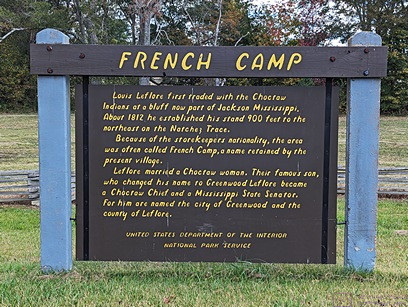
2016/04/11 (M) Parts Run

I was up at 7:30 AM, so I slept over seven hours last night, and felt like I had slept well enough to take on the day I had ahead of me.  I fed the cars, put fresh water in their bowl, and cleaned their litter tray.  I also cleaned part of the shower as one of them has developed loose stools in the last couple of days and has not always made it to the tray in time.  I moved the SunPass transponder, Garmin GPS, and my sunglasses to the car in preparation for my trip today.  By the time I had done all those chores Linda was up and both used our iPads for a while.  I was not going to make coffee this morning since I had a long drive ahead of me sometime today, but Linda wanted some so I made it and had some myself.  We eventually had bagels for breakfast.

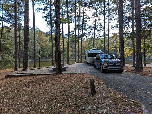
I called Action Mobile around 9 AM and talked to Service Manager John Provo.  He expected my three brake calipers to be delivered between 10 AM and noon but that was just a guess on his part.  Rather than make an issue of getting a more accurate ETA I decided I would leave at 10 AM for the two hour drive from Williston to Orlando.  I went out after breakfast and unloaded most of the stuff in the back of the car and stored it on the picnic table.  I then walked to the resort office to let them know we were expecting a package from Amazon today.

Just before 10 AM I wrote out a short grocery list as I planned to stop on my way back from Orlando at The Publix supermarket on US-27 by the Ocala exit (#354) of I-75.  I took my iPad in case I needed to kill some time at Action Mobile, and actually left a little after 10 AM.

The trip down was smooth, with no traffic issues, and it was uneventful except for a text message from my sister asking me to call our broker and transfer funds for our dad.  Based on when I received it the best I could do was pull into one the Florida Turnpike Service Areas closest to Orlando’s northwest corner and call the brokerage.  The person I needed to speak to (Maggie) was on another call and I did not want to deal with a return call while driving so I left a message that I would call again when I got to my destination, which was still 20 minutes away barring any unforeseen traffic problems.

Traffic was thicker and a little slower as I neared Orlando but it moved along well enough and I reached Action Mobile just after noon.  I called Maggie again and got her this time as she is in the Central Time Zone.  Maggie is our broker’s office manager and is also a registered agent.  We have an extremely good relationship with her and our broker, John, so we chatted briefly before I gave her the transaction details.  I then texted my sister back to let her know I had taken care of her request.

I went inside and found John P. (the Service Manager).  The parts were not there yet so he called Rex at Rush Trucking to check on them.  Rex said they should have been there and made a call.  Not too long after that a white can showed up and the driver unloaded three Meritor boxes of the right size, shape, and apparent weight, and took off.

It occurred to me that I should check the parts before paying the balance and taking off myself so I opened all three boxes.  I was expecting one of the castings to have an “L” in the casting number and the other two to have an “R” in the casting number, but all three had “L”s and that caused me some concern.  I also noticed that one of the calipers had both grease fittings broken.  John P. called Rex back and Rex explained the Left and Right calipers used the same (“L”) casting.  The difference was in the helical drive shaft and gear inside, and difference was reflected in the part number on the box label.  The left side caliper part number began with “A 1” while the right side caliper began with “A 2.”   (The shaft for the calipers on the left side of the bus rotate clockwise, as viewed from the end where the slack adjuster attaches, while the calipers for the right side rotate counterclockwise.)

Rather than have Action Mobile remove and replace the damaged grease fittings Rex had a different left caliper sent over as he did not want to risk a small piece of debris falling inside the mechanism.  When the driver dropped it off I checked the label and the grease fittings.  There were OK, so he put the damaged one in his van and left.

While I was waiting I called Butch and gave him the information on how the left and right calipers were labeled.  He is working with someone at ABC Bus in Muncie, Indiana, who is working with someone at Rockwell-Meritor, who says we can still get these parts with a 45 to 60 day lead time.  I’m guessing that these are also rebuilt/remanufactured calipers, not new ones, but at this point in time we don’t really know.  He was quoted a price that was $200 less per caliper than I paid, but I have mine now, not two months from now; if in fact I could get them.

Bill, the mechanic who fixed our left tag axle brake last week, was taking his lunch break so we got to chat a bit.  John D. (the owner) was also around so we also got to chat for a little while.  I was running behind the schedule I had hoped to keep, so I loaded the three boxes into my car and went inside to pay the balance of the bill.  A quick chat with the billing clerk, Lisa, and I was on my way back to Williston.  It was 1:30 PM and I figured I would be back by 4 PM, including my stop at Publix.

I stopped at the Florida’s Turnpike Turkey Lake Service Area for some lunch but just ended up getting a frozen coffee thing at Dunkin Donuts.  Traffic moved along nicely all the way onto northbound I-75.  I had just passed exit 341 and was just 13 miles short of exit 354, when traffic came to a complete standstill.  The backup stretched as far as I could see in front of me and the flurry of emergency response vehicles driving up both shoulders meant there had been a serious accident somewhere up ahead.

It took at least an hour to reach the accident scene, where police had closed all three lanes of the highway.  All of that of traffic, which included two lanes of nose-to-tail tractor-trailers, had to funnel onto the right shoulder to get around the blockage.  The accident looked really bad and appeared to have involved at least a motorcycle, a large Suburban-like vehicle, and a utility trailer.  There may have been other vehicles involved that I did not see as I drove past or that had already been moved, although I doubted that.  There was no sign of the people involved and I presume they had already been transported from the scene by ambulances or helicopters.

Once I was past the accident I had clear sailing the rest of the way, but from the accident scene north the southbound lanes of I-75 were also completely stopped.  There were also emergency vehicles on the southbound side of the highway, but it did not appear that any of the accident was over there.  I exited I-75 at exit 354 (Ocala, Williston), made a left onto US-27, and pulled into the strip mall on the right where the Publix supermarket is located.

I took my short list of grocery items and went in.  In an unusual move for me I found everything on my list except for one item and did not buy anything that wasn’t on my list.  The only thing I could not get was fresh blueberries, which is odd because just today I had seen billboards advertising the Florida Blueberry Festival as running from April 11 – 16 in a town nearby.  Maybe all of the available blueberries were being routed to the festival?

I was back at our rig around 5:10 PM.  After getting the groceries inside, I turned my attention to reloading the car.  My first task was to transfer the new (to me) A1/Left caliper to the box the DS tag axle caliper came in last week as the box the new caliper came in was in very bad condition.  Linda found our roll of bubble wrap under the bed and I used pieces to protect the grease fittings on the top of each of the three new (to me) calipers.  (I say “new (to me)” because I believe the four calipers I have purchased are all rebuilt, and possibly even remanufactured.)

With that taken care of, I moved a couple of low boxes from the picnic table to the car and put them on the floor behind the two calipers that were behind the driver’s seat.  I then moved the tire covers from the front passenger seat and put them on top of the boxes.  The covers are a soft nylon mesh material which I figured would provide additional protection for the grease fittings.

We disassembled the damaged box to get flat cardboard pieces to use as a cushioning layer on top of the two caliper boxes that I had put inside the wooden storage structure.  The reason for all of this was that I had to store other boxes on top of the caliper boxes and, having received one that had damaged grease fittings, wanted to make sure I was not responsible for causing similar damage.  I had already taken the precaution yesterday of moving heavier items to the front bay of the bus, leaving lighter items for the car.

With the car repacked I opened the box from Amazon, which Linda said arrived around 10:30 AM, to verify that it was the correct Shur-Flo 4048 fresh water pump.  It was the correct box so I left it at that and we went for a long, slow walk around the resort.  When we concluded our walk we sat outside for a while and doodled on our iPads.  John and Ali returned around 6:30 PM.  As we suspected, they had gone out to dinner.  We presumed they had gone to The Blue Highway, but they had gone to The Olive Garden in Gainesville instead.

For dinner Linda made sandwiches with vegan deli slices and lots of greens, kind of like a salad on a bun, and sliced up a Honey Crisp apple.  It was a simple, easy meal, but it was all good.  As the hour approached 8 PM and the light faded we went next door to visit with John and Ali.  Earlier in the day John had taken one of his propane tanks over to be refilled but the person responsible for that task had not taken care of it.  When he tried to light the propane firepit it would not ignite.  We could smell the gas, and hear the spark, but if the tank was near empty it probably did not have enough pressure to make it work.  No problem; the conversation, if not the “mood,” was just as good without the fire.

It was a warm, still evening and there were more bugs out than the last few nights.  Everyone was tired by 10 PM and we all retired to our own rigs.  We watched the end of NCIS-LA and the beginning of the news and then went to bed.  I watched the beginning of The Late Show with Stephen Colbert to see Steve Martin and Edie Brickel, and then went to sleep.  Although I had not really done very much it had been another long, and somewhat stressful, day.

2016/04/12 (T) Water Pump Up

I got up at 7:30 AM and quietly took care of the cats’ food, water, and litter tray.  I measured out the beans for our morning coffee but waited to grind them until Linda was up.  I updated my spreadsheet for GLCC parking at the upcoming FMCA GLAMARAMA16 rally in June and then continued working on my blog post for yesterday.  When Linda got up at 8 AM I finished making the coffee.  We then spent a couple of hours engaged in our usual morning routine of using our iPads while enjoying our coffee and having granola with fresh strawberries for breakfast.

By 10 AM we were dressed and I got to work replacing the fresh water pump.  The pump is a Shur-Flo 4048-153-E75.  It is a 4 GPM (max), 55 PSI (max), self-priming, 12 VDC pump with thermal overload protection and the ability to run dry without damage (although our friends, Butch and Fonda, discovered that it cannot do this for an extended period of time).  Shurflo also makes this pump in 24 VDC and 120 VAC versions.  I am seriously considering adding a 120 VAC pump to the water system when I redo the utility bay, but I would like something a bit more robust.  I seem to recall that Chuck has a Paragon AC powered pump in their Liberty conversion and it impressed me as a very serious piece of equipment.

Since the new water pump was an exact replacement for the failed one installation was very straightforward.  I shut off the incoming fresh water line as a precaution and had Linda make sure the pump power was switched off.  I then disconnected the two power leads which I had wired using mating insulated spade connectors.  There are two fresh water supply lines, each of which gas a 1/4 turn shutoff valve, so I closed those.  (The conversion had two domestic water pumps plumbed in parallel when we first bought it.  I replaced them with a single 4048 and removed the surge tank at that time as Shur-Flo recommended not using one with the 4048 pump.)  The threaded water line connections to the pump are plastic and only hand tightened, so were dealt with easily.  Before removing them I got a towel to absorb the water that was inevitably going to drain out of the lines.  Once the lines were off I removed the four screws that secured the unit to the floor through the rubber shock mounts.  The unit was now completely disconnected and I was able to remove it.

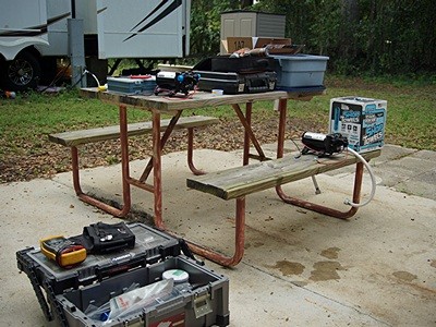
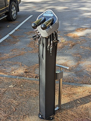
The new and old water pumps along with tool boxes and other stuff needed to make the repair.

Installing the new unit was basically a matter of reversing the steps just described, more or less.  I  needed to attach the proper insulated spade connectors to the power wires on the new pump.  I found my spade lug kit and even though I had a variety of connectors I did not have the ones I needed.  Fortunately there is a NAPA Auto Parts Store very close to Williston Crossings RV Resort and auto parts stores are an excellent place to find a large variety of spade connectors.  It’s walking distance to the store, but I drove there to save time.  I bought several different packs to make sure I had what I needed.

Back at the bus I prepared the power leads and set the new unit in place.  I connected the water lines first as it was easier with the unit loose.  I connected the power leads and then screwed the unit to the floor.  The new pump came with a strainer and adapter fittings.  I used the new strainer bowl to replace the old one, in which I found little curly queues of plastic.  I opened the two shutoff valves and then had Linda turn on the power to the pump and open the kitchen faucet so that both the hot and cold lines were open.  The unit came to life and water flowed, albeit with a sputter until all of the air was out of the lines.  With that, the water pump problem was fixed and I cleaned up the work area and put my tools away.

Next on my task list was checking tire pressures.  I really did not want to check all 12 tires with the digital gauge so I turned on the TireTraker TT-400 TPMS and waited 20 minutes for the readings to update.  Although the sensors are not “dead on” accurate they are close enough to let me know if a tire has lost enough air to require topping up.  They all appeared to be OK so I did not have to get out the air-compressor and air hose.

Barring any further unforeseen circumstances this was our last planned night in Florida for the 2015-16 winter season.  We wanted to go to Satchel’s in Gainesville for pizza one last time.  We decided to have an early dinner and take care of a couple of errands so we left at 2 PM.  Our first stop was at the Kangaroo filling station for gasoline.  Our next stop was Pet Supplies Plus in the Archer Road mega strip mall shopping complex.  We also stopped at the CVS pharmacy in the same complex and then drove to Satchel’s on the east side of town.

Although it was a lovely afternoon, weather wise, we chose to sit inside.  At Satchel’s we had our usual meal; an excellent salad and a pizza with mushroom, onion, sun-dried tomato, and Daiya non-dairy cheese.  It is, quite simply, one of the three or four best pizzas we have ever had, and it is vegan!  We got their largest pie and brought most of it home.

When we got back to Williston Crossings John and Ali were not around and we figured they had gone out to dinner again.  Happy hour usually takes place at Jeff and Kathy’s 5th wheel so we walked down there to visit for a while.  John and Ali eventually returned and as evening fell over the resort we went next door to sit around their propane campfire and visit.  Smitty made a large bowl of popcorn popped in peanut oil and lightly salted with Hawaiian sea salt.  Yum. Note for T 20160412 blog post.  Jim and Janet Rawley came over to John and Ali’s site to visit and John played his guitar and sang for a while.  Jim’s professional name is “Sonny Fox” and he was a big time rock ‘n roll D. J. during the ear when radio stations started playing “album rock.”  Jim quizzed me about my musical background and the first record (45 or LP) that I bought but I had no recollection of that.

We returned to our rig just before 10 PM and were in bed, with the lights out, by 10:30 as we planned to pull out of our site around 7 AM in the morning.  Tomorrow we head north and leave Florida.

2016/04/13 (W) Unbalanced Travel

I set an alarm for 6:20 AM and we got up at 6:30 and got dressed.  Today was a travel day so we did not have coffee or breakfast.  While we prepared the interior of the coach for travel I encountered a problem with the 12 VDC charging plug for the Rand McNally TripMaker RVND 7710 GPS unit.  A small threaded plastic insert, which holds the spring-loaded +12V center contact, had broken and could not be repaired on short notice (if at all).  The two lower 12 VDC “cigarette lighter” outlets were dead again and it occurred to me that the failed plug might have been responsible for shorting the outlet and blowing the supply fuse last Wednesday.  Not realizing this at the time, and desperate to get the GPS back into service, I vaguely recall having plugged it into one of the upper outlets and probably shorted it out too.  I replaced all of the blown fuses last Wednesday but did not realize at that time what the root cause was and was rather perplexed by the failure, which reoccurred on the lower pair of outlets.

I removed the R-M GPS from its usual mounting position (on the driver side lower windshield next to the center pillar and resting on the top of the dashboard cover) and set it aside and I installed the Garmin 465T GPS unit in its place.  I took care of the remaining outside tasks of disconnecting/storing the shorepower cord, connecting the chassis batteries, and opening the auxiliary air supply valve for the engine accessories.  Linda moved the car to another site so it was out of the way as I started the bus motor and aired up the chassis (brakes and suspension).  She then spotted for clearance from obstructions as I slowly and carefully pulled out of our site.

We wanted to be on the road at 7 AM but it was about 10 minutes past the hour when I finally pulled out of the site.  Our friend and neighbor, John (Smitty) Smith, was up and outside to wave goodbye, which was nice.  I proceeded north through the resort on Covered Bridge Road and Linda followed in the car.  We drove through the covered bridge, for which the road is named, and stopped just short of the north bath/laundry building to hook up the car for towing.  There are no park model trailers or RV sites close to this location, so we knew we could hookup here without bothering anyone.  With the car attached we double checked the settings and then did our light check.  Everything was OK so Linda got into the coach and we set our destination in the Garmin GPS unit.

We finished our slow roll through the RV resort, out the back/northwest gate, and pulled out onto FL-121 headed northeast towards Gainesville.  About two miles from I-75 we encountered stop-n-go traffic.  The morning rush hour in Gainesville was underway and was something we had not previously experienced.

Linda kept a close eye on our tire pressures and temperatures, especially the driver side tag axle, as we rolled along.  We stopped at the Pilot station at Exit 460 and took on 60 gallons of diesel fuel.  That was our last stop until we got to the end of our trip for the day.  I would have liked to note here that the trip was uneventful but, alas, that was not the case.

The drive up I-75 through northern Florida and southern Georgia is generally an easy one, without any serious grades to climb or descend, attractive enough scenery, and reasonable traffic volumes except during the April 1st northward snowboard migration.  As we got to the Macon, Georgia area and then on up to Atlanta, traffic was heavier but moved along.  Somewhere along the way the Battery Balance (BAL) light came on, flickering at first but then staying on.  Not good.

The Battery Balance light is controlled by a Vanner Battery Monitor Module and is supposed to indicate that the “12V” center tap on the battery bank is not within +/- 0.75 VDC of 1/2 of the voltage between the “24V” terminal and ground.  The relationship of these voltages is supposed to be regulated by a pair of Vanner Voltmaster Battery Equalizers.  It is normal for this light to come on occasionally, especially when starting the motor, but it is not normal for it to come on and stay on.  Assuming the monitor module is not defective, it means the 12V center tap is out of tolerance with respect to the 24V terminal and implies that the Vanner equalizers are not doing their job.  Ugh.

Having the yellow Battery Balance (caution) light come on immediately added stress to the trip but when the red Hi/Low Battery (warning) light came on the stress level went way up.  This light is also controlled by the Vanner Battery Monitor Module and is (supposed to be) activated if the voltage at the “24V” terminal (relative to ground) is less than 24V or more than 30V.  Voltages outside the 24 – 30 VDC range could indicate a malfunction of the voltage regulator and/or engine-mounted alternator.  Either one would be a problem that could put the bus on the side of the road as the engine is controlled by a computer that is powered by the chassis battery 12 V center tap.

The normal full-charge resting voltage of a “24V” lead-acid battery is 25.2 VDC (12 cells in series at 2.1 volts per cell) and the normal voltage at the 24V terminal with the motor running is around 28 VDC, so the 24 – 30 VDC range is a reasonable one. I also have 24V and 12V analog battery voltage gauges in the dashboard that are connected to the batteries independent of the Vanner Battery Voltage Monitor Module.  While they would also show high or low voltage conditions, and, by comparison, a battery imbalance condition, it is appropriate to have warning lights to get your immediate attention as you might not notice the gauges for a while.  What was odd about this situation was that the 24V gauge was sitting at about the 29V position and the 12V gauge was sitting at about the 14V position.  I knew these gauges worked because they do not always show these readings, but I did not know if the readings were accurate.  They are, however, close to what I normally see, and they do not usually result in caution or warning lights.

We left I-75 (GA) at exit 296, Cassville-White Road, drove 0.2 miles east to the Pilot truck stop, and got in a long to wait for a pump.  When it was finally our turn I added 92 gallons of diesel fuel.  From the truck stop we drove west back towards I-75 and continued 0.5 miles on the other side of the highway before turning left into the Cartersville Castle-White KOA.  Linda was hearing and speaking well enough by now to be able to register us, which is normally her job.  We were escorted to a water/electric pull-through site in the center of the park with less than ideal access but I was able to get in and park the bus.  We leveled as best we could, shut off the engine, batteries, and air and then plugged in the shorepower and turned it on.

Linda made a really good salad for dinner and we each had a piece of leftover pizza, slightly warmed.  Yum.  After dinner I made calls to Joe Cannarozzi, Ed Roelle, and Butch Williams and sent a text to Pat and Vickie Lintner.  Joe was working on a coach in Williamston, Michigan and was looking for a local facility that could service the over-the-road air-conditioning system.  Ed has been around converted buses in Michigan for a long time so I contacted him to see if he had any suggestions for Joe.  We went for a long walk around the campground during which I had a long chat with my sister.  When we got back to our coach I exchanged text messages with Smitty back at Willison Crossings RV Resort.

Our TV options were limited but we were able to get PBS, so we watched whatever was on.  We planned to pullout out of our site at 7 AM, which meant we had to be up around 6:15.  Not that we have that much to do, but we do not like to rush through our morning routine.  We were in bed with the lights out by 11 PM.

2016/04/14 (R) A Relatively Smooth Run

There was a possibility of rain last night so we closed all of the roof vents and narrowed the window openings before we went to bed.  I set the alarm on my phone last night for 6:15 AM this morning, but I was aware of the rain, and woke up around 4 AM when I heard one of the cats making a strange noise.  I wanted to turn on the electric engine block heater anyway so I got up and did that, checked on the cats (they were fine), and went back to bed.  I tried to go back to sleep without complete success.

We finally got up to stay at 6:30 AM and got dressed.  I had an e-mail from Gary at BCM that needed a reply and cc:d Dave Aungier.  I also texted Dave as he was who Gary needed to contact.  I shut down all of the technology and packed up my computer while Linda cleaned off counters and secured windows.  The car was already connected for towing so we just had to go through the towing procedure and double check it.  I disconnected and stowed the shorepower cable, connected the chassis batteries, and opened the air valves in the engine bay.  I started the engine and we did the light check while the chassis aired up.  Since it was 7 AM we tried to avoid idling any longer than necessary before pulling out.

We were in an angled water/electric site in the middle of the campground with fairly tight ingress and egress.  I raised the tag axle so shorten the turning radius and pulled out while Linda kept an eye on the driver side front corner.  I had to get the driver side nose of our coach fairly close the passenger side rear corner of the 5th wheel trailer directly in front of our site in order to get our passenger side rear end and toad to clear a tree on our site and a post near the road on the next site to our passenger side.  I also had to avoid the rear end of the next 5th wheel trailer and the picnic table in-between them.  Fun.

Without being over-confident, I think I have gotten a lot better at maneuvering the bus in tight situations.  That skill has come with some good teaching, some practice, and at the expense of two mistakes that caused some damage, but it certainly paid off this morning.  Once I was cleanly out of our site and into the road I stopped and put the tag axle down.  Linda got on board and we rolled slowly out of the center of the campground and headed for the exit.  We stopped before exiting so Linda could find Juniper.  We knew she was onboard, but we wanted visual confirmation before pulling out.  Linda found her under one of the living room captain’s chairs, and we were on our way.

We recharged the Rand-McNally GPS last night using a 12 V car outlet splitter with USB ports and a compatible USB cable that I borrowed from the Sony a99v DSLT camera.  Linda turned it on and entered the address of today’s destination to verify that the unit was working.  It was, so I set it up on the dashboard by the windshield center pillar so it was ready to go this morning.

Our route took us north on the final 70 miles of I-75 in Georgia to Chattanooga, Tennessee where we headed northwest on I-24.  I-24 was mostly in Tennessee, but dipped back into Georgia briefly as it swung around the southern side of a mountain.  Unless you head far to the west on I-10 before turning north, there isn’t a practical way to get back to Michigan from Florida without crossing mountains.

As you head north from Florida on I-75 the ground rises steadily.  As you approach Atlanta it starts to get hilly, and that continues north of town all the way to Tennessee.  As soon as you head west on I-24 you are perpendicular to mountain ridges running SW to NE.  The highway winds around these ranges, sticking to valleys as much as possible, but inevitably there comes a point where it simply has to go over the top.  And so it did.  I think the grade was at least five miles long, perhaps seven, with lots of turns but nothing I would call a switchback.  The road surface was excellent with wide lanes and truck lanes.  The grade was just steep enough that I had to climb it in 4th gear doing around 50 MPH at 2000 RPM with 14 to 15 PSI of turbo boost.  With cool outside air the engine coolant temperature never rose above 195 degrees F, which is its normal operating temperature (on the gauge) and I was very pleased with the way the bus ran.  Replacing the turbo boost sensor tube last year was no doubt partly responsible for this performance.

The temperature was in the low 50’s when we left the Cartersville Castle-White KOA around 7:15 AM and we ran through cool temperatures under overcast skies, with intermittent drizzle and fog, all the way over the mountains in southwest Tennessee.  Once we were on the northwest side of the mountains the cloud cover started to break up and reveal patches of blue sky.  Somewhere southeast of Nashville we encountered our last raindrops and by the time we merged onto northbound I-65 we had clear, blue skies.  Traveling “north” from late morning to early afternoon we had the sun at our backs, making for a comfortable cockpit without using the air-conditioning.

I was concerned about the issue we had yesterday with the Battery Balance (BAL) telltale caution light and the Hi/Low Battery (Voltage) telltale warning light and presumed it would reoccur today.  In order to reduce the chance of that happening again today I tried to minimize the power draw from the +12 VDC center tap of the chassis batteries and perhaps cause an imbalance between the upper and lower halves of the battery bank.   To that end I did not use the cockpit HVAC fan and kept the headlights off as much as possible.

We had a pretty smooth run all the way to and through Nashville.  Pat and Vickie had alerted us to “construction on I-65” but were not more specific.  North of Nashville we encountered a major construction project that lasted for at least 20 miles.  Traffic flow, however, was very smooth if a bit slower than normal posted speeds.  As we approached Louisville we saw signs announcing major construction ahead and advising I-283W as an alternate route.  We were less than 15 miles from our destination and needed to take the second exit just after the bridge so we rejected the alternate route suggestion and stayed on I-65.  The construction was, indeed, major—the reconstruction of a bridge over the Ohio River—but we made it through without having to stop.  The campground website had very specific and detailed directions on how to exit I-65 and we followed them instead of the GPS.  We were momentarily confused after exiting, never a good thing when driving a bus in an urban area, but we were in the right place and made the last couple of turns to get to the Clarksville KOA campground without difficulty.

Linda checked in at the office and the woman at the desk lead us to a pull-through site that was very easy to get into but might be challenging to exit in the morning.  We were sitting level without having to adjust anything so I shut off the engine and we went through our usual arrival routines.  Linda then walked over to the office and finished registering us.

We walked the park, which was not large, and scoped out our departure route and any possible problems.  The sites here are closely spaced, the roads are a little narrow, and some campers are parked with their vehicles sticking part way out into the road.  Some of the people camped here appeared to be younger men who were itinerant workers.  As such, we suspected they might be gone in their cars before we pulled out in the morning.  If so, we will probably get out OK without having to unhook the car, but I doubt that we will ever return here.  While the location is convenient to I-65 and Louisville, the park itself is not worth the $50 a night they charge.  If not for the location, it wouldn’t be worth half of that.

We did not plan to unhook the car to explore the area and there did not appear to be anywhere to walk although Vickie had texted us that we were only a half mile from the river and there was, in fact, a nice walk down to there.  Even so, we were tired and perfectly content to retire to our coach, have dinner, and watch our favorite Thursday evening CBS comedy shows.  We went to bed at 11 PM as we planned to be on the road at 7 AM so we could be at Butch and Fonda’s home in Twelve Mile, Indiana before noon.

2016/04/15 (F) Back In Twelve Mile Again

I set the alarm on my smartphone last night for 6:30 AM this morning.  Like last night, I woke up around 4 AM, turned on the engine block heater (electrical), and tried to go back to sleep.  I was awake again before 6:30 and the alarm was just my signal to actually get out of bed and get dressed.  Linda woke up with the alarm and was also up and dressed fairly quickly.

As usual for a travel day, we did not make coffee or have breakfast and instead set about preparing the coach for travel.  I had turned off my computer last night so all I had to do was pack it up.   We also left the car and bus connected together, so all we had do was check the connections and go through the towing procedure.  I turned the block heater and Aqua-Hot electric heating element off, disconnected the shorepower cord and stowed it, opened the auxiliary air supply valves, and started the main engine.  We did a light check while the chassis aired up and then Linda climbed aboard.

I was concerned about getting our rig out of the small, tight site and through the narrow interior gravel roads of the campground, but our neighbor’s to the left moved their truck before they went to bed last night and the guy directly in front of us on the other side of the street left in his car just before 7 AM, presumably to go to work.  That meant I had plenty of space to pull forward and to turn to the left, which is the direction the site was angled.  By 7:25 AM we were exiting the park and on our way to Twelve Mile, Indiana.

Although we had less than 200 miles to travel today, I-65 continued to be one long construction zone with lots of very rough surfaces which made for more difficult and tiring driving.  In-between Clarksville and Twelve Mile was Indianapolis, so that meant major urban traffic.  “Indy” is a major shipping hub with a good, but extensive highway system.  I-465 circles the metro area while I-65, I-69, I-70, and I-74 all tie into it, along with several U.S. highways.  The speed limit is 55 MPH and most drivers seemed to obey it, which made for easier urban driving, but there was still a LOT of traffic.

As we got on the north side of town headed west we were looking to exit onto US-31 north.  The GPS told me to exit at Keystone Avenue and turn right onto the relatively new Keystone Parkway, which bypasses the initial stretch of US-31 before joining it some miles farther north.  Fortunately I spotted a sign before exiting the highway that said vehicles over 19,000 pounds GVW were not allowed on the Parkway.  Also fortunate was that I knew the exit for US-31 was only a couple of more miles ahead and was a perfectly acceptable place for us to get off of I-465.  I had not been this way in a while and discovered, to our pleasant surprise, that it is a completely new, limited-access highway heading northbound.  Sweet.

We handled the situation smoothly and without too much consternation, but it was concerning that our GPS tried to direct us onto a road for which we were too heavy by more than double.  That had us wondering if the RV characteristics parameters were not set correctly, and perhaps got reset when I updated the unit while we were at Florida Grande Motor Coach Resort, but now was not the time to check all of that.  This is a relatively recently rebuilt roadway, and it was been my experience with both GPS units that the map updates do not include these newer roads.

Another possibility was that the Indiana Highway Department has not updated the state road database as that is where Rand-McNally (and other mapping companies) get the information for their road maps.  I encountered this a while back when traveling US-24 from Peru, Indiana to Defiance, Ohio.  Even though my GPS database was up to date, it had no knowledge of the new construction between Ft. Wayne, Indiana and Defiance.  The same us still true of the new stretch of US-31 running south from US-20 for many miles even though it has been open for quite a while.  The State highway departments are responsible for updating the database that the GPS/mapping companies use.  If they do not update the database there isn’t much the GPS/mapping companies can do.

Indiana has made major improvements to US-31 over the last 3 to 4 years, building whole new limited access sections.  Besides the section coming south from US-20 and the section going north out of Indianapolis, there is one that now bypasses Kokomo.  The older sections are four lane divided but have grade crossings and occasional traffic signals.  They are posted at 60 MPH and traffic is usually light and moves along well.

All-in-all we had an easy final leg from Indy up to State Road 16 and west into Twelve Mile.  At 11 AM, just 3-1/2 hours after we pulled out of the Clarksville KOA we were back in Twelve Mile again.  We pulled into the gravel driveway for the grain elevator, which is not in use this time of year, to unhook the car.  The driveway is exactly opposite where I park the bus when it is here and positions me to basically back across SR-16 into our spot next to Butch and Fonda’s bus.  Linda spotted for me as I backed across SR-16 and into our spot.  I leveled the coach, shut off the engine, and took care of the exterior arrival tasks while Linda took care of the interior ones.

Butch and Fonda did not come out of the house and we were not sure they were home.  We usually have a very poor Verizon signal when the bus is parked in this spot, and today was no exception, but I was able to get our Verizon Mi-Fi online.  About that time Butch and Fonda came out to check on us and we visited for a while.  We had not knocked on the door because we knew there was a possibility they might not be home when we arrived.

Butch needed to be at a local county fairgrounds at 5 PM to help set up a large room for a hamfest tomorrow.  Fonda was reviewing for the General Class license exam, so Linda studied her Amateur Extra Class flash cards with Fonda while Butch and I went to the do the set up.  The hamfest was an annual joint event put on by four county amateur radio clubs.  After the tables were all set I helped Butch carry in all of the stuff from his truck and arrange it on three adjacent tables.  When we were done, and there was nothing else to do, we returned to Twelve Mile.

It was 6:30 PM by the time we got back and we decided to go out for dinner even though the options for us are very limited.  We drove to Rochester hoping to eat at a Mexican restaurant but it was closed (permanently).  We ended up at Tweedle Dee’s instead, mostly because they have a salad bar.  We were the last diners to leave and only then because they needed to run the vacuum cleaner which cut off any chance of Linda hearing any further conversation.  We stopped at Butch and Fonda’s new (to them) house on IN-25 in Metea but Butch did not have the key with him so we did not get to go inside.

By the time we got back to Twelve Mile we were all tired.  Butch and Fonda had to be up very early to go to the hamfest so they signed their tax returns, got them ready to mail, and brought them to our bus for Linda to mail in the morning.  I planned to go to the hamfest too, but not first thing in the morning.  I also wanted to take our car so I could come back to Twelve Mile before the hamfest ended at 1 PM.

Our series of equipment failures seems to be continuing as I was unable to get the Amped|Wireless SR20000G router/network-extender to recognize any hard wired devices.  I tried plugging in both my computer and our NAS to all five of the ports but none of them responded to either device.  It’s unlikely that the wired networking had failed on both the computer and the NAS so the failure of the SR20000G is the more likely cause.  The SR20000G’s wireless networks are still working but the loss of the wired ports means I cannot access the NAS.  Fortunately we will be home in a few days and I can try to sort this out in the comfort of my office.

Being tired, and with no TV reception, we were in bed by 10:30 PM and I was asleep by 11 with no alarm set for the morning.


2015/11/28 (S) Berea to Cartersville

I did not take any Ibuprofen before I went to bed last night as I felt OK.  I was also very tired and fell asleep without difficulty around 9:30 PM.  Under the best of circumstances I was going to be awake between 4:30 and 5:30 AM and that was the case this morning.  During that hour the cats prowled around the bed, got some attention from me, and looked out the windows.  What they really wanted, however, was food.

The pickup truck / 5th wheel combination that pulled in on our passenger side last night well after sunset was making departure preparations this morning at 5:30.  The strained muscle(s) in my lower right back were nagging at me and, unable to find a comfortable position, I finally got up at 6 AM as the neighbors were pulling out.  I sat on the sofa with the heater pad on my back and worked on my iPad.

The cats still had food and water but wanted fresh kibble, as they do every morning and evening.  It was in the bathroom closet, where it always is, but took me a while to find as it was hiding in plain sight behind the lower rack of hanging clothes.  Linda finally got up at 6:30 AM.  She rarely sleeps 10 or more hours but she was very tired when she went to bed at 8 PM last night and immediately fell asleep.  She also appears to be coming down with yet another cold.  For someone who rarely gets sick she has suffered with colds this fall.

We only had 300 miles to travel today, all on I-75, between Berea, Kentucky and Cartersville, Georgia.  With a fuel stop somewhere along the way it should only be a six hour day.  We got online and checked the weather.  Rain was forecast to start in Berea around 10 AM so we targeted 8:30 to 9 AM as our departure window and decided to have coffee and breakfast.  The cold front was sitting to our west running from southwest to northeast.  It was moving slowly southeast but the precipitation (mostly rain but with some ice and snow) was along the front and sliding northeast.  Based on how it was moving we figured we would probably have rain between Berea and Knoxville and then dry conditions from there to Cartersville where the chance of rain for today was 0%.

I had the engine running at 8:30 AM.  The battery balance light came on and stayed on for quite a while but eventually turned off and did not come back on.  That may just mean the Vanner equalizer was just doing its job.  However, with the upper and lower banks of the chassis batteries on maintenance chargers since we got here yesterday that just begs the question why they were out of balance.  We may be replacing the batteries and/or the Vanner equalizer this winter.

We pulled out of our site at 8:3 AM.  I-75 through southern Kentucky and northern Tennessee was very hilly but the highway was in excellent condition and it was a scenic and pleasurable drive.  Traffic started to get heavy as we approached Knoxville, Tennessee where there was apparently a college football game being played today.  Traffic remained heavy from there to our destination, which made the driving a little more work and a little less fun, but it was still OK.

The bus ran strong all day and I was able to climb the grade at Jellico, Tennessee in 4th gear without dropping below 50 MPH or getting the engine temperature above 200 degrees F (as best I could tell from the gauge) and the exhaust manifold pyrometers not exceeding 800 degrees F.  That was a big improvement over two years ago when I recall climbing up the mountain in the right lane behind slow trucks in a lower gear and worrying about the engine temperature.

Even though I had the cruise control on for most of the drive I did well using downhill speed to go up the other side and getting on the accelerator early to get the RPMs and turbo boost up and keep them there.  I typically saw 15 PSI boost at 2000 RPM but occasionally 16 or 17 PSI.  We really need a 0-20 boost gauge for this engine but I could not find one and doubt that they exist.  Besides, the new 0-30 gauge is working for me and I have other things that need to be fixed/replaced, such as the twin pyrometer gauge.  The left needle used to stick at the bottom of the scale but now the right needle is doing that.  Tapping on the face of the gauge usually frees it up, but not always.  When the needles are both working, however, they are showing the same temperature within 50 degrees F, which is comforting.  I used to think the bus (and me) liked to run at 62 MPH but I have come to the conclusion that it likes to run 65 to 68 MPH, and I am comfortable with that.

We stopped at the rest area about 41 miles north of the Georgia border where I replied to a text from Kristine and then called John Palmer.  He answered this time, said he was glad to have us visit, and gave me the address.  He said he will have customers there but there was plenty of room and we would not have a problem getting our bus in and out.  (Note:  We are also customers, albeit from a few years ago, but this is primarily a social visit and a place to stop for two nights.)  Rather than take time to eat while sitting still we had some pretzel and peanut snacks as we finished our drive to our destination for the day.

We arrived at exit 296 in Georgia around 1:45 PM and pulled into the Pilot Travel Center just southeast of the exit with the fuel gauge sitting at 1/4.  We picked this place to refuel because it is just on the other side of I-75 from our campground for tonight and I wanted to use as much of the fuel in the tank as I could without risking sucking dirt off the bottom or running out.

I figured we would take on 150 gallons of diesel fuel so I added 2 ounces of Racor Biocide, three 16 ounce bottles of Stanadyne Performance Formula diesel fuel treatment, and three 16 ounce bottles of Stanadyne Lubricity Formula.  The PF additive treats 60 gallons of fuel per bottle and I add it to the tank before each fill up in proportion to the amount of fuel I think I will add.  The directions for the LF additive say to “use it 4 to 6 times per year” but that is presumably based on an engine operating in a tractor-trailer or other commercial / industrial use.  Still, I only added one bottle last time when I should have added three, so I added three this time.  We ended up only adding 142 gallons but the extra additive won’t hurt anything.

I reset the trip odometer before we pulled out, which I forgot to do when I filled up at home.  We used to record our mileage and fuel purchases to get an idea of our fuel efficiency in miles per gallon but have never really had an accurate figure for a couple of reasons.  One was that the speedometer/odometer was not working correctly, or at all, and only got replaced in fall 2014.  The other is that the Aqua-Hot and auxiliary power plant both burn fuel from the same tank as the main engine.  Consequently, we can get an approximate idea of fuel consumption if we fill up at the beginning of a long day’s drive and then fill up again at the end before parking for the night, or if we know for sure that we are not going to use the Aqua-Hot or Genset prior to refueling.  Since we will be boondocking from tomorrow afternoon until Tuesday morning we will definitely be running the Genset and probably using the Aqua-Hot.

Our next fill up will probably be on the drive from Williston to Arcadia in late December and the only reason for topping up then is to make sure we pull into Big Tree RV Resort in Arcadia with a nearly full tank to minimize condensation while the bus sits there until early March.  This is one of the reasons I wanted to get all of the additives in the tank today.  We will have full hookups at Big Tree and do not expect to have to run the Aqua-Hot for space heating.  Even though we will have metered electric, we will use the electric heating element in the Aqua-Hot for domestic hot water except possibly for showering.  If the resort has a bath/shower house we might use it if convenient.

From the Pilot station I drove to the KOA about 3/10ths of a mile on the other side of I-75 and pulled up to the office at 2:10 PM.  The KOA is near Cartersville, Georgia.  It is a nice enough place with easy access but the facilities are not as extensive (read that as kid/family magnet) as some KOAs.  Linda got us registered and the woman in the office used a golf cart to lead us to our site.  We got a very convenient 50A FHU pull through site so getting in was easy and getting out tomorrow morning should be equally easy.

We leveled the coach and went through our arrival routine, minus the water and sewer connections.  It was 71 degrees F outside with low afternoon sun was just warm enough in the coach that Linda opened several windows and I put the screen in the door window.  We then went for a walk around the campground.  The place was almost full and seemed to have a lot of rigs that appeared to be set up for long-term stays.  The woman in the office confirmed later that they were fully booked for this evening and that 2/3rds of the campground was in use by extended stay visitors, many of whom were doing work in the area for Georgia Power.  That was certainly not the case when we were here two years ago on December 22nd, so that may have just been a matter of timing.

Back at the coach it was warm enough that we opened two of the ceiling vents and turned the fans on to exhaust air from the coach.  I went to put on a pair of shorts and discovered that we had failed to pack any.  I did bring my two pairs of convertible hiking slacks so I unzipped the lower portion of the legs on one pair and made them into shorts.  Much more comfortable.  I will be doing some shopping once we get settled.

I sent a slightly more detailed text message to Kristine and a daily update text message to Chuck which drew a reply and another text from me.  Linda got our WiFiRanger connected to the KOA Wi-Fi and then logged-in to RVillage.  She changed our location for last night to the Oh Kentucky Campground in Berea, KY and then changed it again for today to the Cartersville KOA.  We were apparently the only RVillage members at either campground.

We were a little hungry so Linda walked to the office to see if they had any hotdog buns, as we left ours behind along with a loaf of raisin bread.  They did not have hotdog buns so she cooked a couple of vegan hotdogs and served them on bread.  We also forgot to unplug the Insta-Hot in the kitchen so she texted the kids and asked them to unplug it and remove the bread products when they were next at the house.

We will be boondocking Sunday and Monday nights so Linda availed herself of the showers at the campground.  I worked for a while on this post and then went over to get a shower.  Linda warned me that it took a while to get hot water so I let the hot water run for at least five minutes but it never got warm enough to shower comfortably.  The men’s bath/shower room was also quite chilly so I took a really quick shower, dried off, and got dressed.  The office had free coffee available so I had some to warm up and mentioned the lack of usable hot water to the woman at the desk.  She seemed surprised but then asked if I let it run a long time, so they know there is an issue.  She said she would mention it to the manager.

Around 6 PM Linda heated up a couple of Amy’s brand Vegetable Korma meals.  As with all Amy’s products they were vegan and tasty, as well as quick and easy, so the quality to efficiency ratio was fairly high.

The antennapoint.com website indicated that we should be able to pick up a few OTA TV stations.  We managed to tune in the ION and PBS affiliates whose towers were NNE of our location and watched a few shows.  Linda read for a while and I checked e-mail and played games on my iPad, which is what I do to relax and/or fill time when

I don’t feel like doing anything else.  Linda was going to make an Apple crisp but did not have enough cinnamon so she added that to her grocery list and cut up an apple to eat.  Around 8 PM she popped the last of the popcorn and added that to her grocery list too.

Around 9:30 PM I closed the ceiling vents in the bedroom and bathroom and took the screen out of the entry door window and closed it.  Linda has had a cough for a few days and has been a bit congested so she went to bed at 10 PM.  I called Butch at 10:15 PM (8:15 MST) but he did not answer.  He does not have a voice mailbox and does not respond to text messages on his phone, so I went to bed.