Category Archives: New Hampshire

20221000 – Miscellaneous Photos Taken by Linda

Special Blog Post

At the end of September 2022, I was going through our photos (Sony SLT and two smartphones) to make sure they were backed up to our Western Digital Passport portable disc drive, as well as backing up the Word documents and processed photos for each blog post.  I try to keep up with this task on a daily basis, but sometimes I get behind.  In backing up the photos from Linda’s phone I came across some that I really liked but had not used in a blog post at the time they were taken.  We take a lot of photos, and only a small percentage of them end up in the blog.  Here are six previously unseen photos, all taken by Linda on her Google Pixel 6 smartphone.

Our Boondockers Welcome host, Rob (The Lake House) baked a loaf of bread (walnut & date) and some cookies for us.  He knew from our Facebook interactions that we were both vegan, so the break and cookies were too.

When we were trying to set up our travel trailer in site #24 at Hadley’s Point Campground in Bar-Harbor, Maine, a fellow Airstream  owner stopped and gave Bruce a small, pink flamingo.  Linda put it on the end of the cabinet by the door, just above our keys.

While we were camped in the Bar Harbor, Maine area we played a round of miniature golf at Pirate’s Cove Adventure Golf.  This is Bruce lining up a shot.

While driving through Gorham, New Hampshire on US-2, we spotted this house.  We were camped in the area for four nights, so the next time we went past it headed east, Linda got this photo.  As the saying goes “our kids and (some of) our money went to U of M.”  (It was money well spent.)  It’s not our Alma Mater, but it was still neat to see this so prominently displayed so far from the center of the(ir) collegiate universe.

We had read reviews about the “camp store” at Brookwood RV Resort in Ticonderoga, New York.  Since we were camped at this RV park for two nights, we checked it out.  It was more like a general store than a camp store.  Linda made me try on the moose hat for this photo, but wouldn’t let me buy it.

I did a whole post on our visit to the Star Trek Experience – Original Series attraction in Ticonderoga, New York but did not include a photo of this partial mock-up of the NCC-1701/7 Shuttle.


20220917 – Burrr, & Mt. Washington, New Hampshire

SATURDAY 17 September

(There are 17 photos in this post, distributed throughout the text.  All photos taken with a Google Pixel 6 Pro smartphone.)

I got up around 0615 this morning.  The zone 2 heat-pump blower had just shut off but the compressor sounded like it was still running.  It should have shut off before the fan.  I needed to get up anyway, but, the change in sound/behavior of the unit got my attention right away, at which point I was wide awake.  The overnight low was forecast to be ~40 (F), but when I checked my phone it indicated 38 (F) in Shelburne, New Hampshire.  I had set the thermostat to 63 (F) before going to bed, so the heat-pump was trying to maintain a 27-degree difference with the ambient temperature outside.  It had cycled on/off all night without any apparent problem.

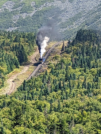
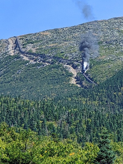
Our first view of the Mt. Washington (NH) Cog Railway.  As we arrived at the base station, the steam train was already chugging its way up the mountain.

I was not sure what the lower temperature limit was for the heat-pump (in heating mode) so,  out of an abundance of caution, I turned off zone 2.  I then went about the business of clearing the kitchen counter of last night’s dishes so I could fill and start the kettle.  Linda was awake by then, so I put zone 2 on furnace mode and proceeded to make our morning coffee.  (The furnace is loud.)  By the time she got up, both of our phones indicated the ambient temperature was 36 (F).  We have been in below freezing temperatures with our trailer before—so we knew the trailer could handle it as long as we had propane and did not let the water hoses freeze—but it’s not something we choose to do on purpose.  I saw 35 (F) briefly, but the temperature started rising once the sun was up.


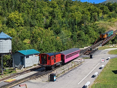
Three bio-diesel trains were loaded and run at the same time.  The first train in line was ‘A’, the second was ‘B’, and the third was ‘C’.  The passenger waiting areas on the loading platform were marked accordingly.  The ‘A’ train is going over the bridge and the ‘B’ train is waiting its turn.

By 7:30 AM our phones were indicating 41 (F) with a forecasted high of 69 (F).  The forecasted high temperature for the summit of  Mt. Washington, however, was 46 (F) under sunny skies, with moderate winds under 20 mph.  And that mattered, because that was where we were headed today to ride the cog railway to the summit.  Assuming this all went to plan, it would be our second visit to Mt. Washington.  The first time, many years ago, I drove our Taurus station wagon to the top.  Linda made it clear that she would never do that again, then and now.  We were not going to hike up (to 6,288 feet), thus the cog railway.  Besides, it the rail line has an average grade of 25%, with sections as steep as 37.4%, and we wanted to ride it just for the experience.

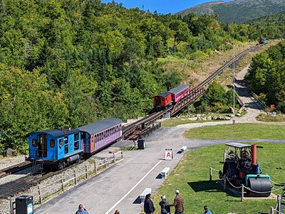
All three bio-diesel trains starting up the mountain.

Linda was checking the route to get there, and discovered that Hwy-16 out of Gorham was NOT the way to go.  Both her iPad and phone indicated that we had to go west out of Gorham and around to the west side of the mountain.  She checked the website, and it clearly stated the many GPS mapping apps do not know how to find the train station, which “is in a remote mountainous area.”  The key was to select Fabyan Station (Restaurant) in Carroll, New Hampshire, as the destination.

Towards the top of the mountain, the cog railway tracks run next to the Appalachian Trail and close to the edge of the deep , closed end of a cirque.  He tracks in this section run on a wooden trestle know as Jacobs Ladder.

I thought I recalled, from our first visit year’s ago, driving north on some road and turning left to get in.  We saw a sign on US-2 going into Gorham that said to go left/south of ME-16 for the “Mt. Washington Auto Road.”  We eventually figured out (read somewhere) that the auto road and the cog railway are on opposite sides of the mountain.  Mystery solved; memory still pretty much intact.


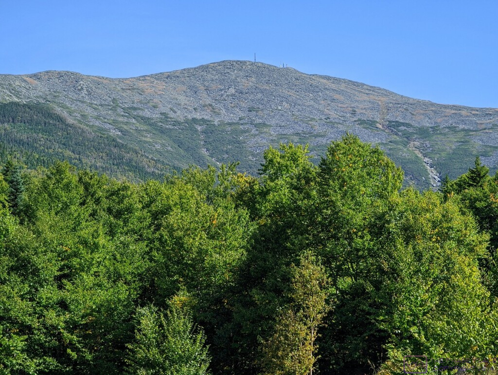
From its base at Marshfield Station, elevation 2,700 feet AMSL, the cog railway passes through four distinct climate zones on its way to the summit, at 6,288 feet AMSL.  Our conductor provided excellent narration on the trip up, and pointed out each zone as we entered it.  The changes between zones were fairly distinct.  (This photo is 1198×902 pixels; click to enlarge.)

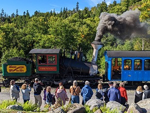
Yesterday, Linda made reservations for the 1 PM bio-diesel train.  (The steam train was already fully booked.)  The website said they board 15 minutes before departure, but suggested we check-in an hour ahead of time.  We left at 10:45 AM for the 50-minute drive.  We were there and parked in plenty of time.  The steam train had left just before we arrived, and we watched it chug its way slowly up the mountain, belching great quantities of black smoke and white steam condensation, before going into the Station.

This is not a trick photo; the camera was level.  Notice that the trees behind Linda and vertical.  The average grade on the Mt. Washington Cog Railway is 25%, but the steepest portions are 37.41%.  The locomotives and the seating (benches) in the passenger cars are designed with this in mind, so the ride up, and down, is comfortable.  Passengers were free to stand up and move around except when going through switches.  Several people on our train did that just for fun.

In the station, we got our boarding passes and then went back outside to the loading platforms and watched the three noon trains, all bio-diesel, load their passengers and pull out.  The trains were lined up, nose-to-tail, and there was a designated loading area for each one.  These areas were referred to as Platform A, B, and C, and each passenger car had a corresponding sign on it.  (I noticed later than the signs were part of a flip-board system, so any given car could be designated A, B, or C as needed.)


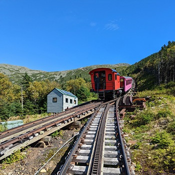
A second rail line was eventually installed from the base   station to the mid-point (approximately).  The switch at this point allows trains to leave the base station and the summit station at the same time.  We were on the upbound ‘A’ train.  There was a delay in the downbound train(s), and we had to wait about 15 minutes at this switch for them to pass.  The ‘B’ and ‘C’ trains were waiting behind us.

Back inside, we passed the time in the gift shop and museum.  There was also a café, but we were not in need of food.  The museum was small, but big enough to tell the story of how the cog railway came into existence.  Construction started in 1866, and it was opened to the public in 1869.  It was the first cog railway ever built.  The first one in Europe was opened in Switzerland in 1871.


The Sherman Adams building at Mt. Washington State Park.  It includes a visitor information desk, restrooms, cafeteria, gift shop, museum, “pack room,” access to the main meteorological station, and a U.S. Post Office branch.  (Linda had some post cards with her, and mailed them from here.)  The State Park encompasses ~ 60 acres of the summit.

As the 3/4-hour mark approached, we moseyed out to Platform A.  Many of the passengers for our car were already there, but no worries about being at the front of a line; all seats were reserved.  We had seats A/11 and B/11 for the round-trip.  The passenger cars were all set up with two seats on one side of the aisle and three on the other, much like a smaller airliner.  When boarding a conveyance, one would normally look for their row (11) and then their seat (A or B).  For whatever reason, the railroad company printed their boarding passes with the seat and then the row, and this seemed to confuse a lot people (rightfully so).  People also seemed to be confused about the fact that if “A” is by the window on one side (it was) then “E” would be by the window on the other side.

The view looking west (approximately) from the top of Mt. Washington.

One of the things we wondered about was how the seats would work, given the steepness of the grade and the fact that the passenger cars could not be turned around at either end of the track.  The answer was reversing (flip-over) seat backs.  Brilliant!  Each time a load of passengers disembarked, the engineer went through the car and flipped all of the seat backs.  Thus, the passengers were always facing in the direction the train was moving.

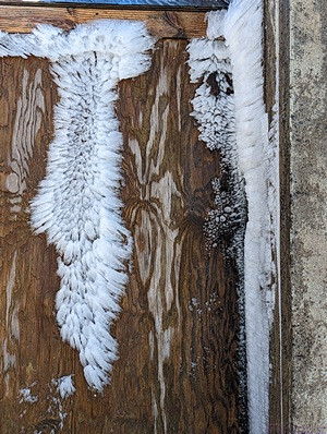
Just a couple of days before our visit, Mt. Washington had 60+ MPH winds with hurricane force gusts above 90 MPH.  Temperatures dropped into the 20s (F) and caused a sudden freezing of the moisture in the air.  Remnants of that event were still very much in evidence, even though it was clear and sunny, with the temperature in the upper 40s (F).  This ice was on a wooden door to a small building.

The bio-diesel trains left Marshfield Station (usually three at a time) on the hour from 9 AM to 3 PM.  (The steam train was slower and left at 8:30 AM and 3 PM.), and operated in such a way that passengers got exactly 1-hour at the summit.  We had seats A/11 and B/11, on the 2-seats side of the passenger car, for the 1 PM, Platform A train.  The ride up took about 45 minutes (approximately 3 miles at 4 mph), plus a 15-minute delay at the switch for downbound trains to get on the second/parallel track to Marshfield Station.  As soon as we disembarked, at 2 PM, the conductor called “all aboard for the noon train.”  These passengers had left Marshfield Station at noon and arrived at the State Park at 1 PM.  Their 1-hour visit was up, and it was time to go back down; same boarding pass for the same Platform and seats, but a physically different passenger car.  One hour after our train arrived, a conductor called “all aboard for the 1 PM train.”  All of the seats were reserved, so no need to stand in line or jostle for position.


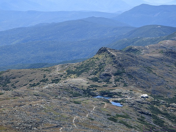
Southwest from the top of Mt. Washington is the Lakes of the Clouds Hut and trails.  About a half dozen trails converge here (depending on how you count), including the Appalachian National Scenic Trail.  Hikers can spend the night here and get food and some other supplies.  The supplies are airlifted in by helicopter several times a year.

The ride up was wonderful.  The cog railway itself is an engineering marvel.  Started in 1866, it opened to the public in 1869.  It was the first cog railway in the world, and has been in operation ever since.  It’s been updated over time, of course֫—most of the trains now use the bio-diesel engines, and the passenger cars are enclosed with operable windows and heaters—but it is genuinely historic, and the operation retains much of that flavor.  And the views … “on a clear day you can see forever.”  Maybe not forever, but we had a very clear day, which was unusual in and of itself, and we could see a long way, up, down, and out.

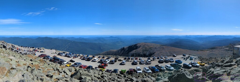
If you drive up the Mt. Washington Auto Road (which we did years ago), this is where you park.  The view is looking approximately southeast.

On our visit many years ago, we were told that on a really, really clear day, you can see the Atlantic Ocean.  We didn’t then, and we didn’t today.  A sign today said that on a clear day, you can see 60 miles in every direction.  There was distant haze today, ad my guess was that that we could probably see about 50 miles, at least in some directions.  I remembered from our last visit that those kind of viewing conditions exist less than 30 days each year, so twice lucky.

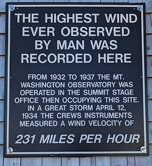
The highest (sustained) winds ever recorded on earth, 231 MPH, occurred here on 12 April 1934.  Mt. Washington is the highest mountain peak in the U.S. east of the Mississippi River and dominates the Presidential Range in the White Mountains of New Hampshire.  The extreme weather here is not just due to its elevation.  The mountain in the path of three major, and three minor, storm tracks.  Visibility at the summit is only good about 30 days out of the year, but we have been lucky enough to be here twice with excellent visibility and relatively pleasant weather.  The highest temperature ever recorded at the summit was 72 (F).

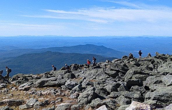
An interesting fact about this whole operation was that 60 acres at the top of the mountain was the Mt. Washington State Park.  Two interesting sub-facts were that this property was acquired from Dartmouth College, and there was no State Park entrance fee.  (My guess was that it was included in the price of , our tickets.)  Another interesting fact was that a large number of trails lead up to and around the summit, one of which was the Appalachian National Scenic Trail.  Besides train and car visitors, there were a lot of hikers on top of the mountain, and we saw many more on the various trails below.  The facilities in the Sherman Adams Building were very much in use by the hikers, whether mailing a post card or letter, or getting something to eat.  There was even a “pack room” where they could leave their packs while they were there.  They could not, however, stay overnight.  The only people who get to stay on the mountain overnight are the meteorologists that work there.


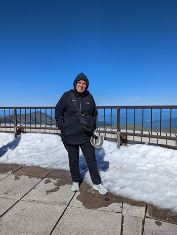
Linda pauses on the observation platform (roof) of the Sherman Adams Building at Mt. Washington State Park.  The white stuff is the remnants of the flash ice event that occurred a couple of days earlier.  The view is looking approximately northeast.

While we were “up top” the air temperature was ~47 (F) and the wind was very modest at under 20 mph.  But the recent flash ice event was still very much in evidence, and 20 mph at 47 (F) has a bit to it.  We had anticipated this, and dressed in layers.  Indeed,   Mt Washington is known for its extreme, and changeable weather.  Hikers need to know what they are doing, have the right gear, check the weather forecasts, and pay attention to them.  Above the 4,000-foot level, cover starts to get thin, and above the 5,000-foot level it is non-existent.  The trails at this level amount to picking your way through  rocks between cairns, which are placed about every 30 to 40 feet.  Visibility can get so low, that hikers cannot see much beyond the next cairn, and there are places where the trail is near the edge of 2,000-foot cliffs.


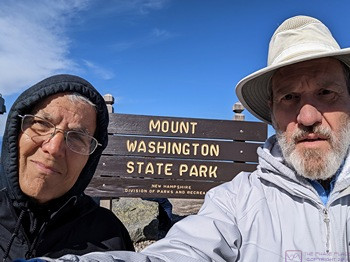
Proof that we were there.  (I’m not good enough with Photoshop to fake a photo like this.)

There were things we did not do at the summit.  There is an actual summit rock with a sign, and there was a long line of people waiting to take a picture there.  Our conductor had suggested we not waste our hour waiting to do that, which was god advice.  We did not get anything to eat, and we did not visit the museum.  Linda did, however, make use of the U. S. Post Office.  She had a couple of post cards with her, and stamps, so she used a pen at the State Park Visitor Information Desk to fill them out, and dropped them in the USPS mailbox.

Back at the Marshfield Station, one of the steam trains was preparing to board its passengers and head up the mountain.

Although the Mt. Washington Cog Railway seemed a bit pricey at first ($87 for each ticket), by the time we got back to Marshfield Station it felt like it was worth the price.  It’s a large, complicated, and no doubt expensive operation.  It was also unique and it is a private enterprise that needs to make a profit.

On the drive back we started to take the Old Cherry Mountain Road, but changed our minds.  As soon as we turned onto it, we could see that it was gravel and narrow.  Our F-150 XLT 4×4/FX4 could have handled it easily, but we were not up for more adventure at that moment.  We returned to our campground via the reverse of the route we took to the Mt. Washington Cog Railway Marshfield Station through the stunning Presidential Range.

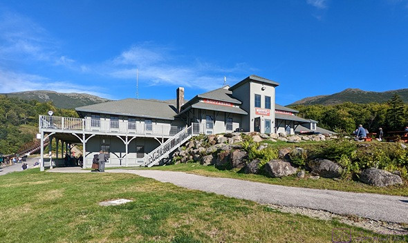
The Marshfield Station building as we were headed back to our truck.  The summit of Mt. Washington is behind the chimney.

Back at camp we settled in and I started working on photos from our train trip.  For dinner, Linda grilled hot dogs and corn-on-the-cob, with fresh fruit on the side a some more of the Menage a Trois Midnight wine.  After dinner, Linda scanned for TV channels but didn’t come up with anything.  We had a good enough Verizon signal that she was able to stream the first episode of the new season of The Great British Baking Show.  It was thoroughly delightful, as always, and a nice change of pace.

20220916 – Bay-gells & Fru-it

FRIDAY 16 September

We were both up just before 7 AM.  I switched the zone 2 controller from heat-pump to furnace.  The heat pump was dropping the voltage from 118-119 to 108-109; not ideal, but it ran all night (off and on) without the Hughes Power Watchdog disconnecting the trailer from the shorepower.

We did not have any specific plans for today so we used our iPads and were not in a rush to have breakfast.  When we got around to eating, we had bagels and fresh fruit (bananas, blueberries, and strawberries).

Linda really wanted to ride the cog train to the top of Mt. Washington and re-checked the weather forecast.  Today was still a “no go” but the forecast for Saturday now looked promising.  She got online and made reservations for tomorrow on the 1:00 PM bio-diesel cog train at Mt. Washington.  (The steam train was sold out.)

Our rig in site 18 at Timberland Campground in Shelburne, New Hampshire.

Scott came over and I went out to meet him.  He pointed out that the 50A electrical outlet was in the meter box.  Duh.  (Sometimes it feels like my parents wasted their money on my EE education.)  We had a nice chat; he was a former boat mechanic with a lot of electrical experience.  He and Megan just bought the campground this past May, and plan to be open for approximately 5 months every year; mid-May to Columbus Day (October).  The wiring to our site, and the one on either side of us, was new/upgraded and he said voltage drop should not be a problem.  (I later confirmed that this was, indeed, the case.)

I learned a few interesting things.  The campground was built starting in 1970 and opened for business in 1972.  All utilities were buried, but the tree roots are starting to push them close to the surface, which is a problem, especially for tent stakes.  The increasing demand for 50A electrical is also problematic for them, and will require some effort and expense to address.  He said the previous owners also did not keep up with tree maintenance, so they have quite a bit of work ahead of them in that department as well.  Megan runs the “front of the house” and Scott takes care of the “back of the house.”  They are experienced campers, whose camping aesthetic does not require 50A power (or any shore hookups at all).

Our driver-side next-door neighbor was out preparing their rig for departure, and he joined the conversation for a few minutes.  They are headed to the Bar Harbor KOA.  Our best guess was that they are headed south after that, as it starting to get cold here at night, and they have yet to visit the Southeast U.S.

Timberland Campground is an interesting piece of property.  It lies between US-2 and the Androscoggin River, but an active train line runs through the park lengthwise.  About 35% of the campground is on the other side of the tracks, and fronts the river.  The River Walk (trail) winds through that section and we took a break in the afternoon to check it out.  Scott had mentioned that there was bear scat on the trail from last night, and it was pretty obvious when we got to it.

Linda decided she wanted to get a haircut, and her online searched turned up a salon at the local Walmart.  So, our big plan for the day was to drive the ~3 miles to Gorham, NH and take care of that.  She called to see if she needed an appointment, and was told there was presently a 5-minute wake for walk-in.  We made quick to depart, and were on our way to town.

Linda was happy with her haircut, after which we did a little grocery shopping.  We pickup up two bottles of wine, nothing special by brands and style we like (Ménage à Trois Midnight Dark Red Blend and Barefoot Riesling).  (The red one went in the refrigerator when we got back to camp, to chill down for later.)

The Androscoggin River as seen from the Timberland Campground River Walk (trail).  We were surprised by how fast the water was moving.

We thought we might do some sight-seeing, but with fresh and frozen food in the truck, we decided to return to camp and didn’t feel like just driving around anyway.  Linda had looked for wineries in the area last night, but didn’t find any nearby.  (We would really like to find a bottle of blueberry wine, and should have bought one while we were in Bar Harbor, Maine.)  We searched again this morning, and found that the closest winery was in North Conroy, about 40 minutes south of Gorham on NH-16.  Their website said they had “fruit wines” (not made from grapes).  And there were open on Sunday, noon to 4 PM.  Linda also found two vegan café/bakeries!!!  One of them was open 9AM –  3 PM on Sunday and served breakfast.  Bonus!  The weather forecast for Sunday was favorable, so a trip to North Conroy on Sunday for breakfast and wine was the plan.

We found this very unusual looking mushroom along the River Walk.  Google Lens could not identify it.

Mid-afternoon, we explored the River Walk (and found the bear scat Scott had told me about this morning).  The campground starts at the level of US-2 and drops slightly towards the River.  Behind the last, long row of sites, the terrain drops off sharply and then flattens out for the train tracks before dropping off again to get down to the flats by the River.  The area by the River is where most of the River Walk is located.

The rest of the afternoon I worked on the blog and Linda read.  It was beautiful, but chilly outside, and we were content to stay at home and stay warm.  The 50A electric service was a winner; maintaining 119 Volts AC or better with the larger heat pump running and the electric element for the water heater turned on.  We enjoyed a cup of tea and didn’t have to manage our power in order to use the kettle to boil the water.  I guess that meant we were “glamping” (glamor camping), but to us it’s just the way we camp these days.

Dinner was baked potatoes with all the (usual) fix’ins of sauteed vegetables, vegan cheese and sour cream.  We each had a small glass of the Ménage à Trois Midnight Dark Red Blend with dinner.  We had Oreo cookies later for dessert.

The forecasted low temperature for tonight in Shelburne was 40 (F), with a Frost Advisory from 0200 to 0800 Saturday morning, so we were glad to have the 50A electric service as the zone 2 heat-pump was going to run quite a bit overnight.

By 11 PM, I was ready to upload the blog posts for the previous days and appeared to have a robust enough Internet connection to get it done efficiently.  I had them both published by 11:35 PM and turned in for the night.

20220915 – Hadley’s Point CG (MDI, Maine) to Timberland Campground (Shelburne, New Hampshire)

THURSDAY 15 September

(There are no photos for this post.)

Today was another travel day, but with slightly different timing than usual.  Yesterday morning, we signed up for the “honey wagon” service for this morning, as it would be a lot more convenient than stopping at the sewage dump station on the way out of the campground.  The campground provides the service, and they start emptying waste tanks at 8 AM.  They prioritize rigs that are pulling out that morning, but could not tell us more specifically when they would get to us.

As an aside, it is the 15th of the month.  We started this trip on the 15th of June, and this was our 93rd day/night on the road.  We will be home in 25 more days (24 more camping nights after tonight).

We had an estimated 4-1/2- to 5-hour drive to our next campground, which had an earliest check-in time of noon.  We would have had to leave at 7:30 AM to be there by noon, but there was no reason to do that, and we needed to have the waste tanks emptied before we pulled out.  There was a chance we would be the first rig they emptied, so we wanted to be up and ready in case they got to us early.  Linda set an alarm last night on her Fitbit for 7 AM, but we were both awake and out of bed a little before that.

We each had one cup of coffee, half-caffe for me and high-test for Linda, and I had a banana for breakfast.  We then started working on our departure preparations.  While Linda started getting the interior of the trailer straightened up and battened down, I started on outside tasks.  I moved the hitch stinger from the back seat floor of the F-150 to the receiver and secured it.  I then packed up and moved our technology to the truck for travel, along with our wine box.  (All of that sits flat on the floor in the back seat.)

Linda had finished the dishes, and our fresh water tank was at 56%, so I started disconnecting and stowing our shore water components.  I hadn’t gotten very far when the honey wagon showed up around 8:15 AM.  It was one of the older guys who works at the campground.  He was very pleasant, and hoped we had enjoyed our visit to the area and our stay in their campground.  Except for the initial problem with our original site (#24) we had, in fact, had a very nice stay.  (The annoying things, like $4 for a load of laundry and pay showers, weren’t actually annoying as we did not need to use them.)

I finished disconnecting the shore water components and Linda helped drain the hoses.  With all of that stowed away, I positioned the truck in front of the trailer with the stinger lined up with the hitch.  I got it close on the first try and close enough to work on the second try.  It usually takes more tries and adjustments than that.  Linda turned the LevelMatePro+ on and I used the app on my phone to recall the hitch height for connecting the truck and trailer.  It was only slightly off from the hitch so I adjusted it by eye, and proceeded to back the stinger in with no problem.

We secured the hitch and connected the safety chains, breakaway switch cable, and umbilical cord.  When then set the WD jacks to the pre-determined height that we have used the whole trip (3-1/2” protruding).  We pulled the rubber chocks and removed the X-chocks, and stowed them in their respective places.  I then needed to pull forward to get the Andersen Levelers out from under the driver side trailer tires.  Unfortunately, we had done some things out of their normal sequence and had stopped referring to our hitching list, which resulted in me pulling forward without raising the trailer tongue jack.  That was a big mistake that could have had very undesirable consequences.  Thankfully, it didn’t, but it was a mental lapse on both our parts, and the first time we had made this particular mistake.

The last steps were to move Juniper-the-cat from the trailer to the truck (Linda) and disconnect and store the shorepower cord (me).  A final walkaround, inside and outside, and we were ready to go.  We pulled out of our campsite at 0920 with an ETA of 1348.  Five miles, and 10 minutes later, we crossed the bridge on ME-3 over the Mount Desert Narrows and said goodbye to Mount Desert Island and all that it had to offer.  We had thoroughly enjoyed our visit, but we had a schedule to keep and had to move on.

Our destination today was Timberland Campground in Shelburne, New Hampshire.  We had looked at routing options last night, and initially thought we would travel north from Mount Desert Island to Bangor, and then SW on I-95 to Augusta, and then head west on ME-219, picking up US-2 in Bethel, Maine.  The detailed directions, however, seemed to involve more road changes than that, and I wanted to simplify the navigation today.  We decided to take ME-3 north to Ellsworth, pick up US-1A north/west to Bangor, and get on I-395 west.  At the interchange with I-95, I-395 ends and becomes US-2.  Timberland Campground is on US-2, so that should have been the end of that.

To get the navigation system in the F-150 to go the way we wanted, we had to choose the “shortest” route option.  We should have known better, as that inevitably leads to some strange routing decisions where it takes us off of a main road, like US-2, onto smaller backroads (or through subdivisions) in order to save 0.1 miles.  Linda was following along on her phone, and spotted most of these diversions, but we both missed one for lack of a road sign indicating how to stay on US-2.  No worries, though; the system knew our campground was on US-2 and took us back to the highway.  My reason for wanting to stay on US-2 was that US highways are usually truck routes, which means then have the height clearances and weight capacities needed for semi-trucks. And if they can make it through, we can make it through.  In this case, I was also trying to minimize the number of different roads we would have to navigate.

We were still driving through low mountains for most of the day, so the roads had lots of curves and lots of up and down.  The entire drive was very nice, however, with partly cloudy skies, cool temperatures in the low 60’s (F), and signs of fall in the colors of some of the trees.  We did, however, have strong, gusty winds that made us feel like we were back in Atlantic Canada.  It also reminded us how well the Propride 3P hitch works, and how glad we were to have it.  Did I feel the wind?  Sure, just like I feel bad road surfaces.  Did the trailer ever give any indication that it might sway?  No, it did not; because it can’t (it’s mechanically impossible).

Timberland Campground is owned/operated by a young couple, Scott and Megan.  Linda registered with Megan in the office while Scott moved a picnic table out of our site (#18).  (W3W=”digesting.cheaper.reached”.)  The campground is gated, and required a $20 (cash) deposit for a Gate card, but we were aware of that ahead of time, so Linda was prepared.  Scott also told her to not leave any trash or food outside the trailer, as “the bears are real here.”  (There are black bears in this area.)

Our pull-through site was another one of these sites where you “pull-through” an open grassy area to get in or out.  (In our case it would be out, and won’t be a problem.)  It did not look promising at first, but I managed to easily position the trailer so it was level, side-to-side, and only 3/4″ off in the front.  Linda moved Juniper back to the trailer and put out her food and water bowls, and then rejoined me outside for the unhitching process.

Following our unhitching checklist, we put the tongue jack down to take some of the tongue weight and proceeded to install the rubber chocks and the X-chocks on the trailer tires.  We then disconnected the safety chains, breakaway cable, and umbilical cord.  I set the hitch height for disconnecting using my usual technique of feeling and watching for the trailer tongue to pull away from the hitch and the ball hitch latch lever to move.  The over-center-latches (OCLs) released without the truck or trailer moving, which is usually an indication that I have the trailer tongue height set correctly.

However, when I pulled the truck forward, and pulled the stinger out of the hitch, the trailer dropped an inch or so.  I never let things like that pass without trying to figure out ‘why.’  My analysis of the situation was that the truck was sitting over a high spot.  As I pulled forward, the front/steer axle was going slightly downhill and the rear/drive axle was going slightly uphill, raising the rear end of the truck relative to the trailer and lifting the hitch.  Linda would not have seen that unless she was looking for it.  Again, no harm, no foul.  I adjusted the tongue jack to  get the hitch opening height aligned with the stinger height, and saved the setting in the LevelMatePro+ app.  I then adjusted the trailer tongue jack to level the trailer, front-to-back.

Linda went inside to start preparing lunch, which was a hot dog, potato chips, and red grapes, while I connected our shorepower.  Our “50A” full-hookup site turned out to be a 30A full-hookup site.  Not a problem; I have 30A(shore)à50A(trailer) adapters and have used them a lot on this trip.  But we booked and paid for a 50A electrical service, which this clearly was not.  The price difference was $3/day, so not a big deal for a 4-night stay, but as a matter of principle, Linda went to the office to get the $12 refund.

Scott had left the campground to run errands, but Megan walked down to our site.  Megan was surprised that it was only 30A as Scott had assured her that there were outlets for both 50A (4-wire) and 30A (3-wire) service, and she understood the difference.  We have managed on 30A service quite a bit over the last 3 months, but were looking forward to the convenience of the 50A service.  She said Scott would look at it tomorrow, which was fine with me.

Our driver-side neighbors were a somewhat younger couple with two younger children, but apparently retired and on the road full-time for the last 18 months.  The husband noticed the Propride 3P hitch and offered his approval.  A quick glance confirmed that he also had one on his F-250 and travel trailer.  They also had X-chocks, Anderson levelers, and a Hughes Power Watchdog.  He approvingly told Linda later that we “had all the cool toys,” as did he.  They were pulling out tomorrow morning and heading to Mount Desert Island where they have reservations at the Bar Harbor KOA.  I told him about the Island Explorer bus service, downtown Bar harbor, and the Pirate’s Cove Adventure Golf.

With the trailer set up, and lunch taken care of, Linda stripped the beds and added the bedding and towels to what was already in the laundry basket.  The laundry room here had four functioning washing machines and four functioning dryers.  That is not a given in many RV parks.  The washers were $1.75 per load (there were $ 4 at the last place) and $1 for a 30-minute cycle on the dryers.  Very fair pricing.  I set up our Verizon Jetpack Mi-Fi and got my computer set up to use.

The high temperature here never made it much above 60 (F), and started dropping well before sunset, so we never opened any of the windows in the trailer, and closed the door sooner than we normally would.  I turned the furnace on, and set it for 68 (F), but still traded in my shorts and short-sleeve shirt for my sweat pants and shirt.

Dinner was Amy’s frozen entrees, Indian this time, with mixed vegetables, dahl, and basmati rice.  Quick, easy, and tasty, but not large servings.  We had popcorn later.

The only thing we had discussed wanting to do while in this area was take the cog train to the summit of Mt. Washington, New Hampshire, but it appeared that might not be possible or desirable, due to the weather.  Winds of 60+ mph, with hurricane force gusts, were pummeling the summit and forecast to continue tomorrow.  Temperatures were dropping into the 20s (F) and ice was forming.  We have “warm layers” in our clothing arsenal, but we were not outfitted for those kinds of conditions.   The weekend looked to be warmer and less windy, but overcast with a strong possibility of rain.  If that forecast holds up, we won’t go but, as has been the case through our trip, the weather/forecast often changes by the time we get close to an event or destination.  We will look at this again tomorrow for Saturday or Sunday.  Otherwise, we will likely take the truck and go sight-seeing, and possibly search out a winery and/or vegan restaurant.