Category Archives: Nova Scotia

2022902 – Stary Night & Quiet Day at Halifax West KOA, Nova Scotia

FRIDAY 02 September

I was up late last night and did not get to bed until 12:30 this morning, so it was nice to be able to sleep in until 7:30 AM.  I had spent the evening writing and editing photos but, as dusk turned to night, had noted that cool temperatures and clear skies were on tap for the evening.  While not a dark sky area, the sky above our RV park was starting to reveal a fair number of stars, including some fainter ones.  The Big Dipper was prominent, as always, in the NNW sky.

Around midnight I went out to have another look.  After letting my eyes adjust, I was able to just make out the Milky Way, running from horizon to horizon, ENE to WSW.  I decided to try and get a photo of a portion of it, just to see if I could.  I set the SONY SLT a99v on manual mode, 25600 ISO, 24mm focal length, f/2.8, and tried various shutter speeds (exposure times).

I didn’t bring a tripod on this trip, so I tried setting the camera on the picnic table pointing skyward, but I couldn’t get the camera shutter to trigger.  I did not bring my remote release cable on this trip either, so that option was not available.  (In fact, I left most of my camera gear at home.  The available storage space in the trailer and truck require decision about what to bring.)  That meant long, hand-held exposures, guaranteeing less than perfect, and probably unusable, results.

Astro-photography is its own little niche which, like all photo-niches, exists at the intersection of photography with some other interest.  I was fascinated with astronomy as a pre-teen and young teenager.  My involvement with photography as a hobby began when I was 16, by which time my interest in astronomy had faded.  Perhaps I thought it was cool to stay up late at night when I was 10 -13 years old but, for whatever reason, I never pursued Astro-photography.

I did recall, however, our time in Arizona in the spring of 2015 when we were camped with Val and Lou Petkus (silent key) just north of Organ Pipe Cactus National Monument.  Lou had acquired a SONY mirrorless camera that had excellent low-light sensitivity and was eager to try it out.  We were in a dark sky area, and he knew the Milky Way would be visible as an arc across the southern sky above the low mountains to our south.  I remembered that he used a high ISO setting of at least 12,800 and used exposure times from 8 to 20 seconds.  He had the camera on a tripod, of course, with the lens at its widest aperture and focused at infinity.  The photos he got were amazing, and revealed details that were unavailable to the naked eye.

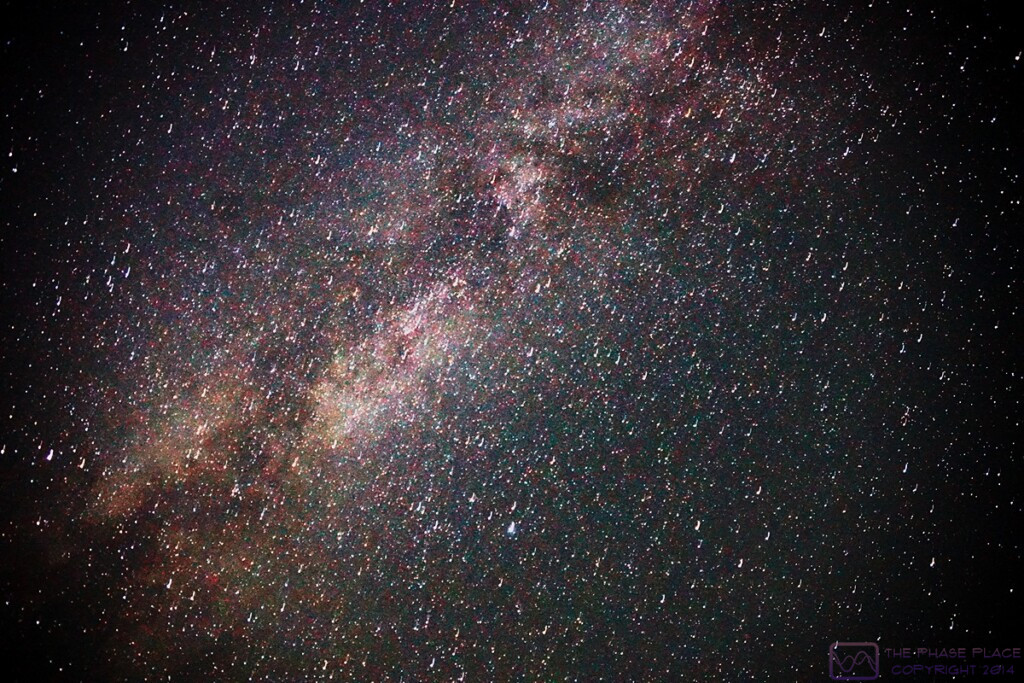
I tried to emulate what Lou had done, as best I could without a tripod.  I tried exposure times from 1 to 20 seconds.  While the shorter exposure times resulted in less camera movement, they did not collect enough light.  One shot, however, looked like it might work.  It was a 20 second exposure that I made while lying on my back on the picnic table bench and bracing the camera.  It looked completely overexposed, and had slight movement, but the exposure histogram showed the image values fairly well centered, and substantial.  I was able to process this image in the morning to produce this result:

PHOTO – 1200x800_Milky-Way_02 …  The Milky Way as seen from the Halifax West KOA in Nova Scotia a 0025 (ATZ).  Handheld, ISO 25600, 24mm, f/2.8, 20 seconds.  Post processed with Faststone Image Viewer.  (This image is 1200 x 800 pixels, so can probably be viewed at that size on a device with a large enough screen.)

The Milky Way as seen from the Halifax West KOA in Nova Scotia a 0025 (ATZ).  Handheld, ISO 25600, 24mm, f/2.8, 20 seconds.  Post processed with Faststone Image Viewer.  (This image is 1200 x 800 pixels, so can probably be viewed at that size on a device with a large enough screen.)

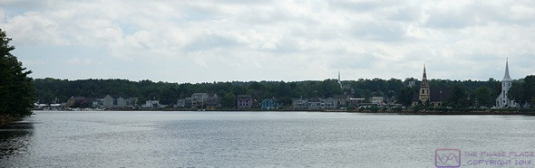
A gorgeous day was on tap, with blue skies, no rain, and a high temperature in the upper 60’s.  Our original plan for today was to drive into the Annapolis Valley, north and west of the KOA, as far Annapolis Royal.  The Annapolis Valley is essentially agricultural, however, which did not command our enthusiasm.  This would, however, have taken us through Windsor, Glooscap (Mi’kmaq First Nation), Wolfville, and Kentville, which is wine country.

While we hated to “waste” such a day, we were both a bit tired and not really looking forward to a 5-hour round-trip sight-seeing drive in the truck, especially with a travel day coming up tomorrow.  And, as much as we love wineries and vineyards, we would be re-entering the USA in 9 days, and did not want to buy any more wine than we could drink between now and then.  We briefly considered other options, such as a return to Peggy’s Cove or a drive up the first part of the Eastern Shore, but both sounded like too much driving.  In the end, we opted to step back from tourist mode and just stay in camp.  Since we were not going anywhere this morning, Linda made pancakes for breakfast, one of the perks of “camp days.”

Linda decided that she wanted to get a haircut and searched online for someplace not too far away.  She found a salon nearby in Mt. Uniacke, and called when they opened at 10 AM.  “Walk-in only, no appointments, and probably tied up until 2:30 PM.”  Her plan was to drive up around 2 PM.

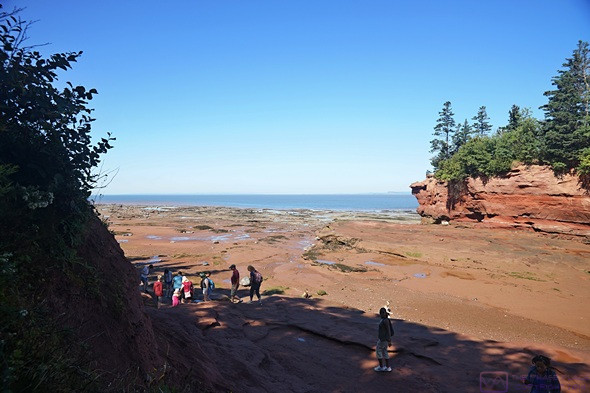
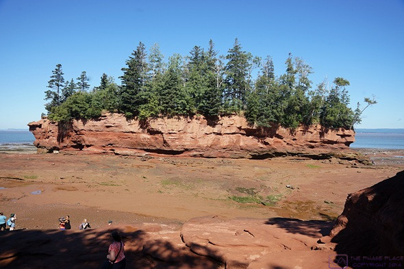
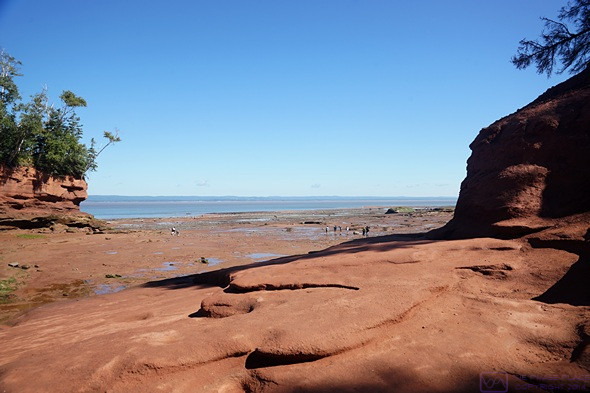
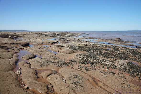
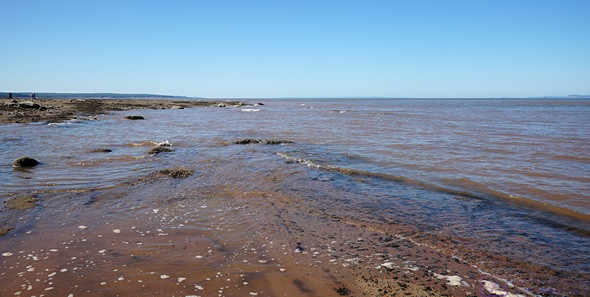
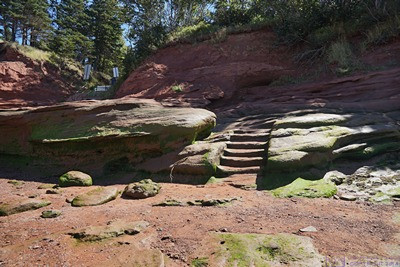
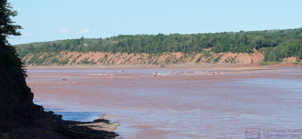
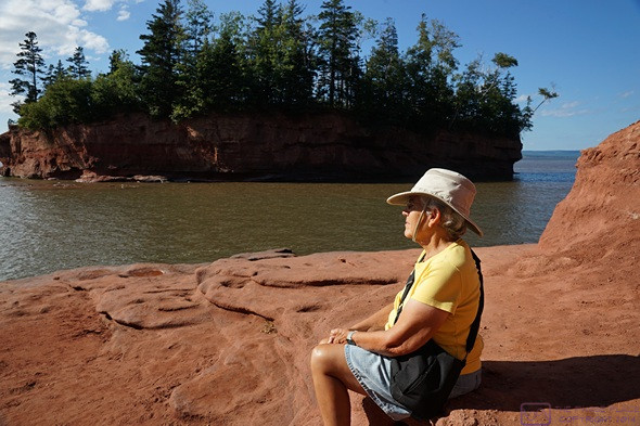
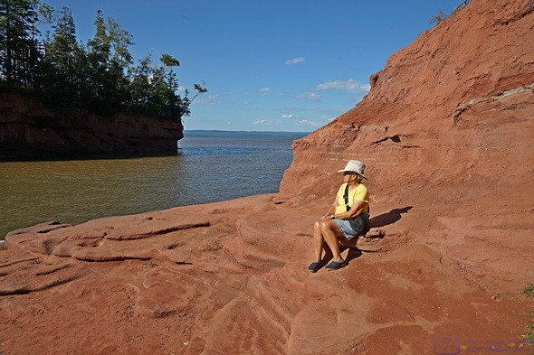
She was glad to have a day in camp, and spent 30 minutes cleaning the floor before going outside to read.  I was also glad to have a day in camp, as I still had to process the photos from our trip to Burntcoat Head / Park yesterday, and finish writing the blog posts for August 30 and 31, and September 1, which included deciding where to place photos and writing the captions.  I also needed to upload, assemble, and publish them, but wasn’t sure if the RV Park Wi-Fi would be adequate for that during the day.

Around 1:30 PM we had a light lunch of Fritos and spicy roasted red pepper hummus along with a nectarine.  As 2 o’clock rolled around, Linda decided that she did not feel like going out to get a haircut after all, and resumed her reading.  We went out briefly around 3:30 to top up the fuel in the truck and pick up a package of hamburger buns.  (Our bakery buns from Sobeys had spoiled and had to be thrown out last night.)

Linda decided to grill hamburgers and Brussel’s sprouts for dinner, so we got the grill out and set it up.  After dinner, we went for a long stroll through every part of the campground.  By the time we finished our walk, the sun was dropping behind the trees and the temperature was dropping along with it.  The overnight low tonight was forecast to be 48 degrees (F).  She cleaned the grill and we loaded it back in the truck along with our camp chairs.  We had the last two So Delicious non-dairy ice cream bars for dessert.

We are just under 3 weeks from the autumnal equinox, and the hours of daylight have definitely diminished compared to the beginning of our trip and or our much more northern locations.  We are now very near the 45th parallel, which runs through the northern tip of Michigan’s Old Mission Peninsula (in the lower peninsula), but still north of the latitude of our home.  While there will be daily variances, the average high and low temperatures are definitely dropping with each passing day, and the chill in the evening air is a prelude to fall.

The Wi-Fi at this KOA has not been great, but it has not been terrible either.  When we can connect to it, it often works reasonably well.  But when all of our devices need multiple things updated, it’s a challenge to get it done.  As has been the case with most of our RV parks on this trip, early morning and late at night have been the workable times.  My Google Pixel 6 Pro smartphone, informed me that I was 1 to 2 days late installing a system update which was 1.2 GB in size.  I get 500 MB (0.5 GB) of data per day.  It needs to be done, of course, and we tend to be meticulous when it comes to installing updates in a timely manner but really, Verizon, how did you think I was going to accomplish this?  We had a lot of updates for our iPad apps too, so I suspected an iPadOS update was also coming soon.

Linda headed off to bed at 10 PM and I turned down my bedding so it would be ready later.  She set the zone 2 heat-pump to heating mode and the thermostat to 62 degrees (F).  The temperature sensor was already indicating 64 degrees (F), so it would definitely run during the overnight.

At 23:45 I logged in to our WordPress site and started uploading and assembling the blog post from our Tuesday visit to Peggy’s Cove and Lunenburg.  I finished the process right at midnight and published it.  I was on a roll, so I proceeded with the post for Wednesday’s visit to Halifax.  I clicked the “publish” button at 12:24 AM.  It started the process, but then indicated it had lost connection with the Internet and was backing up the post in the browser until the connection was restored.  At 12:25 the connection re-established itself and the process finished successfully.  I deleted the 42 spam comments that had come in since the last time I logged in, and then logged out.  Getting these two posts published was a big deal for me; they were both long and had a lot of photos.  I will probably have to deal with the posts for Thursday and Friday (this one) once we get settled at our next RV park. I headed to bed at 12:31 AM.  Not ideal the night before a travel day, but we did not have to leave early which would allow me to get enough sleep.

20220901 – Burntcoat Head & Shubencadie River, Nova Scotia

THURSDAY 01 September

(Note:  This post has 24 photos, distributed throughout the text.)

It was August when I went to bed last night, and September when I woke up this morning.  We have been traveling for about 10 weeks, and this was the fourth of five months of five months that our trip would span.  We have made good use of our “base camp” at the Halifax West KOA in Upper Sackville, Nova Scotia, to explore the southwest end of the Province.

This is the view at low tide looking to the northwest from the platform and ledge that provide access to the ocean floor at Burntcoat Head Park.  The land on the far horizon is still Nova Scotia, on the other side of Cobequid Bay and the Minas Basin.

Based on a tip we received in the Visitor Information Center at Peggy’s Cove, our main destination today was Burntcoat Head Park, on the south shore of the Bay of Fundy, specifically the west Cobequid Bay portion of the Minas Basin in the Bay of Fundy & Annapolis Valley tourist region.  Before continuing, here’s a quick overview of Nova Scotia’s seven tourist regions:

  • Bay of Fundy & Annapolis Valley – This might be the largest region in terms of area. Every part of Nova Scotia that touches the Bay of Fundy is in this region.   We had already been to the Tidal Bore Interpretive Center in Truro, at the eastern tip of Cobequid Bay, when we first entered Nova Scotia many weeks ago.  Up to Windsor, it is easily accessed from Truro and Halifax.
  • Cape Breton Island – We spent enough time here to see the Cape Breton Highlands, drive the Cabot Trail, see a bit of the north shore of Bras d’Or Lake, and visit North Sydney. We did not see the west end of Bras d’Or Lake or the area south and west of North Sydney.  North Sydney was our point of departure and return to/from Newfoundland and Labrador.
  • Eastern Shore – This region includes the Atlantic Ocean shoreline from Halifax east to Cape Breton Island. It is punctuated by numerous inlets and dotted with islands and little villages.  It is one of the more difficult parts of Nova Scotia to visit, and we were told that cell phone service is very spotty.  We did not get a chance to find that out for ourselves on this trip.
  • Halifax – This is largest city in Atlantic Canada, Canada’s major Atlantic Ocean port, and the only city considered to be major in national terms (population ~250,000). Within the context of Atlantic Canada, however, Moncton, NB and St. John’s, NFLB are also consider to be “major” cities.  It sits at the boundary of the Eastern Shore and South Shore regions.  We could easily have spent a week exploring Halifax.  We only visited for one day, but saw the things that were top of our list.  It’s a busy, congested place.
  • Northumberland Shore – This region lies along the Northumberland Strait across from Prince Edward Island and runs from the border with New Brunswick to Cape Breton Island. It includes the cites of Pictou, New Glasgow, and Antigonish, and is considered the “Scottish heart” of Nova Scotia (New Scotland).  We drove along and through it, but did get to spend time exploring here.
  • South Shore – This region runs along the Atlantic Ocean southwest from Halifax to the southern tip of the peninsula. It’s home to Peggy’s Cove & Lighthouse, Mahone Bay, and Lunenburg.  Like the Eastern Shore, it is punctuated with numerous inlets, bays, and coves and dotted with a few islands and quaint towns and fishing villages.  It is more accessible, however, due to Hwy-103 and generally more tourist oriented, which means it also has good cellular service.  We allocated one day to this region, and only got as far as Lunenburg, but it was a good day and gave us a sense of the region.
  • Yarmouth & Acadian Shores – This region occupies a small portion of the southwest tip of the southwest peninsula, between the South Shore region and the Bay of Fundy & Annapolis Valley region. The main city is Yarmouth.  It’s the most difficult region to get to (km and hrs) but our guide book said it’s worth the effort as this is “authentic” Nova Scotia that isn’t set up to please tourists.  You can also get here by ferry from Bar Harbor, Maine.

This is the entire island across from the access point to the ocean floor.  The coloration was a clue as to how high the water would eventually rise.  The island across from this access point is the key landmark for making sure you get back to the stairs to exit the floor before the tide comes in.

We knew before we left that we had not allocated enough time to explore Atlantic Canada, or even do just to a single province (although we did our best with Newfoundland).  We are happy with the choices we made, but have also learned a lot and will be well prepared to plan our next visit(s).

This is the view looking towards the northeast between the island and the mainland.  The land on the far horizon is still Nova Scotia, on the other side of Cobequid Bay.  Truro (not visible) is to the right at the far eastern end of Cobequid Bay.

This is our feet, standing on the ocean floor at Burntcoat Head, Nova Scotia.

As for today, we had picked up a copy of the tide chart for Burntcoat Head at the VIC in Peggy’s Cove, so we new that low tide was at 11:05 and high tide was at 17:07.  Burntcoat Head was almost due north of our campground.  Most of our route was on secondary Hwy-354.  We left a little after 10 AM and it took about 53 minutes to drive the 41 miles (~66 km), arrive just before low tide.


The following is from the Wikipedia entry “Burntcoat Head, Nova Scotia.”

“Burntcoat Head had a public wharf that has been the location of a tide gauge since the 19th century. The tide gauge at Burntcoat Head was operated by the Canadian Hydrographic Service and has recorded the highest tidal range in the world. Currently, the tidal gauge is no longer in operation. Tides at Burntcoat Head average 55.8 ft (17.0 m), with the highest being set during the 1869 Saxby Gale at 70.9 ft (21.6 m).

Like pretty much every place along the ocean around the world, Burntcoat Head experiences two high tides and two low tides each day. The Bay of Fundy fills and empties with approximately 160 billion tonnes of water twice a day. On average it takes 6 hours and 13 minutes between high and low tide. As soon as the tide has reached its lowest or highest point it will change directions and either begin to come to shore or flow back out. Each day the tides times will change approximately by one hour.

Burntcoat is a part of the Triassic Lowlands Region. The Minas Basin and Cobequid Bay was formed from rivers that eroded from the Bay of Fundy. Burntcoat Head shoreline and ocean floor is made from Triassic red sandstones and conglomerates.

This large area to the east of the access stairs is empty now, but at high tide the water level will be part way up the bluff on the right.

Part of the north side of the Island, looking west towards the Bay of Fundy.  (It’s way off there, and it’s really big.  The Bay is 400 km long and very wide at its mouth with the North Atlantic Ocean, but funnels down into long narrowing bays such as Cobequid, which is where the really high tides occur as the water piles up.)

When the tide recedes, it leaves behind pools of water, from large to tiny.  Every tide pool had living things in it, like this one.  (The little crab, center right, was about the size of a Canadian quarter.)

The Wikipedia entry also mentions Burntcoat Head Commemorative Park and the replica Lighthouse, which is owned and operated by the Municipality of East Hants, but it does not mention the other main reason we sought this place out; we were able to walk on the ocean floor at low tide.  (You can actually do this from ~3 hours before to 3 or more hours after low tide, as long as you remain aware of the time and what the water is doing.  Other than injury from a slip/fall, the big danger is getting cut off from land as the tide comes in.)  The Wikipedia entry also did not mention that this park is open to the public, free of charge.

We found this seaweed all over the ocean floor, and thought it was particularly interesting.


The Park had a nice gravel parking lot, a bathroom building (not pit toilets) and a gift shop in the replica lighthouse.  A nice path led down to a wooden platform with stairs down to a sandstone ledge.  From there we picked our way down using “natural” steps until we got to a place where actual steps had been carved into the sandstone for the last four or five feet to the ocean floor.


We stayed out for ~2-1/2 hours and took a lot of photos. We walked all the way out to the water’s edge, which I estimated to be about 600 meters (~3/8 of a mile) from the entry stairs.  While we were at the water’s edge, Linda noticed rocks at the water line starting to disappear.  We stepped back and watched the water level rise and move inland.  We kept stepping back, and eventually retreated to higher ground to watch the details of the shoreline change right before our eyes.  It was an amazing thing to witness.  By 1 PM we were getting a bit hungry and worked our way back to the stairs.

A selfie with the island behind us.  The edge of the water is a little way in front of us.

Linda had packed a simple lunch of PB&J sandwiches, grapes, purple potato chips, and water.  The Park had 8 picnic tables, but most of them were occupied, except the ones in the sun.  We had our camping chairs in the back of the truck, and Linda suggested we get those out and use them.  I carried them over to the picnic area and set them up in a shady spot while she brought the Styrofoam cooler.

Bruce sitting on a rock in front of the north side of the island (facing the Bay).  (Photo by Linda.)


We were done with lunch by a bit after 2 PM, packed up our chairs and cooler, and headed for the Fundy Tidal Interpretive Center in Maitland.  The Center is a few kilometers east of Maitland, and it took about 30 minutes to drive there.  We arrived at 2:50 PM to find a good-sized crowd of people standing on a platform at what used to be a pier for a long-gone bridge over the Shubenacadie River.  It turned out that they were waiting for a tidal bore!


The entire north side of the island from hear the water’s edge.  This island was once connected to the mainland by a narrow strip of land, and was the site of the original (1st of 4) lighthouse.  The Fundy tides are very powerful and the sandstone of the Bay is constantly eroding.

View to the west towards the Minas Basin, with Linda near the water’s edge.

A view to the northeast from the north side of the island.  That’s still Nova Scotia on the other side of the Cobequid Bay.

We like these long, narrow channels, and noticed water starting to flow into them.

We had been standing in this area not 10 minutes earlier and moved back when saw the rocks start to quickly disappear under water.

The last few steps to get onto the ocean floor, and get back off, were literally stairs carved into the sandstone.

The river is much larger than the Salmon River in Truro where we saw the tidal bore many weeks ago, and it did not produce a wave front, as such.  But as the tide moved up stream, we saw the water start to churn, almost as if it was boiling, and eventually the water in the river was flowing away from the ocean instead of towards it.  Afterwards, we spent a few minutes in the Information Center and then headed back to Burntcoat Head Park.

About 25 minutes east of Burntcoat Head was the village of Maitland, and about 5 minutes farther east was a bridge over the Shubencadie (Shoo Ben Ka dee) River.  Just before the bridge was the Funday Tidal Information Center.  The piers for the former bridge where still there, and the near shore one now supported a viewing platform.  The Shubencadie flows north into Cobequid Bay near its mid-point.  Like the Salmon River at Truro, it experiences a Tidal Bore with each high tide.  Flowing from our right to our left when we arrived (towards the ocean) we got to watch the flow slow down and the water start to “boil” and then start to flow upstream.  Kayaks and inflatables had followed the advancing tide water and appeared to our left playing in what looked like rapids from our vantage point.

A quote from Joseph Howe, a 19th century politician for Hants Country, regarding Nova Scotia and the Fundy tides.


The reason for our return to the Park was to see and photograph the area where we had walked, only a few hours before, filled with 13.8 m (45.4 ft) of water.  Low tide was clearly the more “interesting and unique” time to be here, but seeing the exact same place at high tide allowed us to understand the magnitude of this tidal phenomenon.  Twice a day, the Bay of Fundy fills and empties 100 cubic kilometers of water weighing 160 billon tonnes.  It’s a lot of water.


Like Peggy’s Cove, the Burntcoat Head Park access to the ocean floor is open to the public to use at their own risk.  And there is risk, and there are warning signs explaining them.


Before going back down the access platform, we used the restrooms and ten spent a few minutes in the replica lighthouse which has a museum on the second floor.  I also went up in the light room for a look at the view, but there was no ventilation and it was very hot.  (The park was open until dark, but the restrooms and lighthouse closed at 5 PM.)


The area of the ocean floor to the west of the stairs is the habitat of an endangered species known as the “mud-pillock.”  The staffer on duty at the entry platform re-stated all of the safety issues for every visitor, and specifically said the area to the west was “off limits.”  No one walked in that direction, but we did see a few people who went around the east end of the island, down to the shoreline, and then headed west.  Apparently, some people don’t think rules apply to them.


Seeing the bay filled with water was impressive, all the more so since we had been standing there just a few hours earlier.  Unlike low tide, however, there wasn’t really anything else to do beyond looking and contemplating.  The Park has viewing area to the west and claimed to be a good spot to watch sunsets, but that weas still about 3 hours away.


Yet another warning sign explaining the potential hazards of this site.


I got the photos the I wanted to show the change from low tide and high tide and, after sitting for bit and just looking at an amazing sight, we headed back to the truck for the return drive to camp.  We took essentially the same route back, but went the other way (south) on Etter Road which saved a couple of miles and minutes.


Back at camp, it appeared that someone had organized a party and not invited us.  The RV park was fairly busy, with lots of children running around and cars occasionally parked at the front of campsites and partially into the road.  The kids were fine, the cars partially block the road, not so much.  But it was fine.  We relaxed for a while, having been on our feet for a good part of the day.


A sign in the lighthouse/museum building with the entry from the Guinness Book of World Records.  (Photo by Linda.)


Linda made a nice salad for dinner, after which we went for a stroll around the park.  Although we don’t appreciate folks cutting through our sites at RV parks, we are not those “grouchy old people” who don’t like children.  We enjoyed our time as a camping family when our children were young, and we enjoyed seeing other families out doing the same thing now.  We also took note of the fact that our site here (E07) was at the far end of our section, had relatively little traffic (pedestrian or RV) and was relatively quiet compared to the party central section by the bounce pad and ice cream shack.


Linda sitting on a higher level of the entry ledge at high tide.  Compare to an earlier photo.  The water is just below the edge of this platform and is half-way up the side of the island.  That’s a lot of water in the space where we were standing just hours earlier.

I spent the rest of the evening writing and processing photos while Linda continued to read her current book.  We chatted a bit about our plans for tomorrow and came to the conclusion that we would probably just hang around camp and take it easy.

A view of Cobequid Bay to the northeast.  The ocean floor where we were walking around has disappeared under 45+ feet of water.  Linda is looking northwest towards the Minas Basin.

20220831 – A Grave Experience, and the Halifax Citadel National Historic Site (Parks Canada), Halifax, Nova Scotia

WEDNESDAY 31 August

(Note:  There are 20 photos in this post, spread throughout the text.)

Monument for a known victim of the Titanic disaster; a crew member who stood his post and went down with the ship.


I got up at  0630 this morning, took care of my cat chores, started my laptop computer, and then cleaned our coffee cups.  I had a cup of half-caff as today was a sightseeing day for us, with a possible early departure, checked e-mail, and worked on the blog post for yesterday.  Breakfast was avocado toast with fresh blueberries and banana on the side, and a small can of V-8 juice.


Another monument to a lost crew member of the Titanic who stood his post and went down with the ship.  The inscription captured the English sense of duty.


For this last day of August, 2022, and our second full day at the Halifax West KOA, we planned to do some more exploring of area.  We wanted to get to Burntcoat Head Park—on the western end of the Cobequid Bay end of the Minas Basin portion of the Bay of Fundy—to see the low and the high tide.  (We learned about this place yesterday from the staff person at the Peggy’s Cove Visitor Information Center.)

The low tide at that location today was at 10:25 AM, with dry, sunny weather.  The high tide was forecasted to be 45.6 ft (~14 m) around 4:25 PM, but it looked like rain would start around 3 PM.  The weather forecast for Halifax, on the other hand, called for partly cloudy to cloudy skies, with an elevated chance of rain starting around 5 PM.  We like to keep the weather in our favor as much as possible, and decided to head into Halifax today.

This marker really underscored for us the loss of entire families in the sinking of the Titanic.


We were getting close to a laundry day, and Linda wanted to get it done sooner rather than later.  She searched online and found a laundromat in Lower Sackville.  She suggested that we stop there on the way back from Halifax, so we gathered up all of our soiled items and loaded them in the car, along with our iPads.  We entered the address for Fairview Cemetery, and pulled out of our site shortly after 10 AM.


This marker was at the “bow” of the gravestones.  The odds of survival for most of the passenger was low, but especially so for children.


Like many of the Canadian cities we have visited on this trip, Halifax has a crazy road system.  We are probably spoiled by having lived for so long in the Detroit Metropolitan Area of Michigan, where the road system is largely based on a N-S and E-W grid.  But Eastern Canada is hilly, at best, and downright mountainous in many places, and the roads just go where they have to go, including up and down steep grades.


Halifax is also the largest city in Atlantic Canada, at ~250,000 residents; not large by big city standards, but the largest metro area we’ve been in since we left the Quebec City area on June 30th.  We quickly discovered that folks here drive a bit crazy after we saw three vehicles ahead of us run red lights.  Duly noted; defensive driving required here.

The view of the Titanic Graves from the “bow” of the ship.

People die in all sorts of ways, some horrible or tragic, but these markers, for victims who were recovered by never identified, evoked a particularly lonely sadness.

We got the sense that the Titanic Graves get a lot of visitors.  Tasteful, understated signs made them easy to find.


Our reason for visiting Fairview Cemetery was that 121 victims of the Titanic disaster are buried there.  The cemetery was not huge and signs directed us to the Titanic Graves.  We were not the only visitors; other cars were already parked along the edge of the road.


A view of the Titanic Graves portion of Fairview Cemetery from the “stern” end of the ship-like arrangement.  The camera is level.

The grave markers were arranged in four columns.  Two of the columns curved to meet at a point like the bow of a ship.  A short, third column was inside those two.  The marker at that “bow” was for a 19-month-old toddler whose identity was unknown at the time, but has since been determined using modern methods.  Indeed, quite a few of the markers were for unidentified victims.  While a few have been identified, most remain unknown.  The 4th column ran alongside the others.

Grave sites at Fairview Cemetery of some of the unidentified victims of the 1917 munitions explosion in Halifax Harbor.

Most of the Titanic grave markers were small and identical.  These were provided by the White Star Lines, who owned the Titanic.  Each bears a number corresponding the order in which they were pulled from the sea.  Many victims were never recovered, and some were buried at sea.

There was also something moving about the fact that every marker had the exact same date of death, April 15, 1912.  A few of the small markers had been replaced with larger ones.  We presumed they had been provided by the victims’ relatives.  There were two other smaller Titanic Grave sites in Halifax, but we did not visit them.

The Halifax Explosion of 1917.


The sinking of the Titanic was not the only disaster, however, whose victims were buried here.  Just five years later, during WW I, a munitions ship in the harbor exploded, killing 2,000 people and injuring 9,000 more.  A small area at Fairview was the final resting place for a few of them who were never identified.


Our parking spot INSIDE The Halifax Citadel.  A good deal for 3.50$.  Right away we got a sense of the massive nature of its construction.

Our next stop was the Halifax Citadel.  By definition, it was a fortress that sits on top of a very large hill and usually has its own defenses.  In this case, the hill was very strategically located, overlooking the harbor with a view all the way out to ocean.  (The view is not so clear now, due to a lot of high-rise buildings, but we were still able to see off to the horizon in many directions.)

An entrance road wound around the hill and up to the top.  There was free parking at pull-offs along the way, but they were all full.  We got to an entrance booth with a big “P” sign and an arrow pointing into the actual fortified area.  We waited in line behind several other vehicles to find out what the deal was.

The deal was that our Parks Canada Discovery Pass covered our admission to the site (of course), but not to this particular parking area.  However, for 3.50$ we could park inside the fort.  Yes, please.  A steep entry ramp went down into an outer courtyard where Parks Canada had made a parking lot.  We found an open spot, backed the truck in, and walked through an arch in a stone wall into the Information Center.  We got a map, walked out into the innermost part of the compound, and waited about 5 minutes for a gun crew (of park employees), in uniforms, prepared to fire a large artillery rifle.  Boom.  The noise display concluded, we walked the upper ramparts, which still had many guns and rifles on display, and then went back down to the main level to look in some of the rooms.

The gun crew moves the artillery rifle into position for firing (blanks, of course).


An opening with stairs going down took us to the lower area between the upper/inner walls and the lower/outer walls.  Parks Canada had used this space to recreate a view of the WW II Invasion of Normandy.  Although built out of plywood, the various props were convincingly painted to look like steel, iron, and concrete.


Starting from a simple mock-up of the bow of an LTA (landing craft) we looked out the bow across a beach to the land and houses beyond.  In-between were large log devices designed to tip the landing craft over, followed by iron structures that resembled “jumping jacks” designed to stop boats that got past the logs.  Beyond that was the minefield, and beyond that the “pill box” for the machine gun.

A park staffer said the recreation was supposedly close to life size.  Movies are one thing (Saving Private Ryan), but this allowed us to actually “walk up the beach.”  (As an aside, my father was in the invasion of Normandy shortly after his 19th birthday.  His unit landed at Omaha Beach, Red Dog Sector, and had a 90% casualty rate.  I’ve tried over the years to understand what that must have been like, but I cannot, even after seeing this recreation of the setting.  It must have been truly unimaginably horrible and terrifying.)

The gun crew “lights off” the large rifled artillery piece.  It made a big “boom” sound, but not as loud as the smaller canon at the Signal Hill NHS in St. John’s, NFLB.


The Citadel is one of five military National Historic Sites in Halifax.  Two are on islands.  The other two were farther south, and we did not visit them.  The Citadel is massive in its construction, made almost entirely of stone surrounded on the outside by earth.


It’s actually the 4th Citadel that Great Britain built on this site.  Starting in 1828, it took 28 years to build and was completed in 1856.  This was a British fort until 1906, when the garrison left and it was handed over to the Canadian militia.  And It was a bit strange to stand here and think about the fact that one of the “enemies” it was built to defend against was us, as in the USA.  But the threats to Great Britain in the 18th and 19th centuries also came from France, Spain, and Germany.  Although the Citadel never fired a shot in anger (self-defense), it played important roles in both WW I and WW II.

One of the large canons on the ramparts with the barracks building in the background.

Linda had researched vegan dining options in Halifax and located a Copper Branch on the waterfront, about a mile from the Citadel.  We left the truck in the parking lot inside the fort and walked to the restaurant for lunch, arriving at 2 PM.  Linda had a breakfast bagel sandwich and I had the Aztec bowl with smoked tofu.


We discovered this chain in Ottawa, Ontario, and found another one in Rimouski, Quebec.  The menu is 100% vegan, and the food has been excellent every time.  Halifax is built on the west side of a large, deep bay on ground that rises sharply from the water, so it felt like our walk to lunch was about 1/2 mile horizontal and 1/2 mile vertical.  That’s an exaggeration, of course, but that’s how it felt, especially on the way back.


The Halifax Citadel dates from a time when flags were still the main way information was communicated between shore installations and ships.  The signal flags were stored in this small building and hoisted up onto the two masts as needed.  The mast on the left had twelve peripheral ropes/pegs and six inner ropes/pegs.  I appeared to be designed to hoist multiple smaller flags in two vertical columns.  By comparison, the mast on the right only had two sets of two ropes/pegs each.  It appeared to be designed to hoist two very large flags, one on each side of the mast.


Back at the Halifax Citadel, we finished our exploration of the fort with the Canadian Army Museum on the second floor of the former barracks building in the center of the interior ground.  It was a relatively small but very nice museum; well-curated, with artifacts well-displayed and well-described.  I am not a military history buff, but I found it fascinating just the same.


A recreation of a small piece of Normandy Beach, France on D-Day, 1944.  This view is from inside the mockup of an LCA (Landing Craft, Assault) which carried the infantry troops ashore.  The Germans knew an attack was coming but did not know where it would occur.  The log structures were designed to tip over the LCAs.  The iron “jumping jacks” were designed to stop the LCAs if the made it past the logs.  If troops managed to make it ashore (many did not), they had to cross a mine field, beyond which were “pill boxes” housing machine guns.

Linda had also researched laundromats, and found one in Lower Sackville.  On checking further, she discovered that it had really poor reviews.  She located another one only 5 minutes from the Citadel, so we drove there instead.  Downton Halifax is a dense urban area, so we expected parking to be a problem, and it was.  This was a small, neighborhood laundromat in a somewhat bohemian neighborhood, in which we suspected some of the residents did not have washers and dryers, either in their apartment or even their building.  There was one open parking spot across the street (naturally), but I was unable to get turned around owing to the myriad of one-way streets in this part of town, and intersections where left turns were not permitted between 3 and 6 PM.  It was already after 4 PM, of course.

A view of one the rooms in the barracks building at The Halifax Citadel.  11 men “lived” in this room.  They slept and took their meals here, and tended to their daily chores or whatever activities occupied their time when off-duty.  Note the bed which fold in half lengthwise when not in use.  This made room to use the tables in the center.

We decided to bail out on this option, head back to the RV Park, and see if the laundry room was available.  The laundry room is near the office at the entrance to the park, so I dropped Linda there with the intent of heading back out to the Irving fuel station on Hwy-1 at the egress to Hwy-101.  Several RVs had pulled in to register, however, including an older Airstream Classic Limited (3-axle) that we passed on the highway.  None of them pulled to the right, so the entrance lane was completely blocked.


World War II radio equipment display.  The technology that was developed and used in this war was amazing.  It was the first “modern, industrial” war but, unfortunately, not the last.

The Airstream pulled up, perhaps thinking he was helping the situation, but made it worse.  The last building on the right on the way out is a “park model” unit.  The car parked in front of it was not as far enough off to the right as it needed to be, and the space between it and the rear end of the Airstream was too small for me to get through.  So, I sat and waited.

The Alexander Keith Brewery in Halifax, Nova Scotia.  Established in 1820, and in continuous operation since then, it lays claim to being the oldest continuously operating brewery in North America.

One-by-one, people got registered and moved their RVs, making room for the RVs behind them to pull up and continue to block the entrance lanes.  There are two of them by the office, and RVs are supposed to pull to the right while they register.  But the Airstream finally pulled up far enough that I could get by.

The Irving station was only 1.2 miles back up Hwy-1.  Traffic was light in my direction, but heavy coming the other way, including at least three RVs in a row that I presumed were headed to the KOA.  In spite of heavy traffic exiting Hwy-101, the station was not that busy and I pulled right through to a pump.  Credit card accepted, gasoline pumped, F-150 mileage computer reset, and I was on my way back to camp.

In my brief absence, the flagger for the construction project just beyond the entrance to the KOA, had stopped traffic.  When I became the last vehicle in line, there were about 8 vehicles between me and the KOA entrance.  But the flagger did not let traffic go, and the line behind me grew until it was out of my sight.  (I imagined it might have backed up all the way to the highway egress.)

A closer view of the sign for Alexander Keith Brewery.  Tours were available, but we did not have time to take one.

A pickup truck from somewhere behind me pulled out and passed me on the left and then cut through the stalled traffic into the KOA.  I decided I could do the same thing, and a car a few ahead of me actually beat me to the punch.  But at least I was finally back in the RV park and not sitting in traffic.  I checked in with Linda.  The laundry was empty when she got there, so she had snagged both washing machines and had use of both dryers.  She said it would be another hour or so before the laundry was done.

Back at our trailer, I started my computer, gave Juniper-the-cat her afternoon kibble, and settled in to check my e-mail, copy photos from my phone to the computer, and start working on the blog post for today.  I still had work to do on the post for yesterday, but wanted to capture today’s events before the details got lost.

Linda texted me at 5:43 PM and I drove down to pick her up.  It had started raining, off and on, by then, but not hard and we got the clean laundry inside without it getting wet.  We both spent a little while putting our clean clothes away.  Linda made her bed, and I left mine for later, as there is only room in the aisle to make one bed at a time.

I cleaned out our coffee cups from this morning and we each had another cuppa; decaf for Linda and half-caff for me.  Linda finished up the dishes from this morning and we settled in for the evening.  We skipped dinner as we were not hungry, but had some popcorn around 8:30 PM.

The weather forecast for tomorrow looked good, so we planned to go see the tides at Burntcoat Head on the Bay of Fundy.

20220830 – Peggy’s Cove and the Lighthouse Road to Lunenburg, Nova Scotia

TUESDAY 30 August

(Note:  There are 17 photos in this post, spread throughout the text.)

The ATVers we met at Channel-Port-aux-Basque, Newfoundland, were from Halifax and warned us about the “Black Rocks” at Peggy’s Cove.  We arrived to find lots of signs warning of this specific danger.  I can’t imagine coming to such a beautiful place and dying as result of my own stupidity, but it apparently happens several times every year.

Today was the penultimate day of this August, and we were eager to start exploring this part of Nova Scotia.  Since heading south from Truro towards Halifax yesterday, everything we saw was new to us.  As we have found throughout Eastern Canada, the Provinces are subdivided into named regions.  These regions are not governmental but rather for tourism, and Peggy’s Cove is the starting point for exploring “The South Shore” region of Nova Scotia.


The day started out heavily overcast but with no threat of rain.  We spent some more time studying our maps and Atlantic Canada guide book and then settled on a plan for the day.  After our usual morning chores, coffee, and a light breakfast, we got ready to go sightseeing.


Finnish-born artist William deGarthe’s 30-meter (~98 ft) carving depicting the fisherman, families, and lives of Peggy’s Cove.  This was carved into an exposed granite rock adjacent to his studio.  He started the carving in his 70’s, and it took him 8 years to finish.

William deGarthe’s studio / art gallery.  It was not open during our visit.  He is known for his nautically themed oil paintings which, according to our guide book, “grace galleries the world over.”  We did not see any images during our visit to Peggy’s Cove.

Our route took us back down Hwy-101 to Hwy-102 towards Halifax and along its western edge to Hwy-103, which headed southwest along the South Shore (but not right by the water).  We eventually left Hwy-103 for Hwy-3, “The Lighthouse Road.”  As we had seen in Newfoundland and Cape Breton Island, scenic routes have names.  Provinces also have mottos, and Nova Scotia’s is “So Much to Sea.”


Hwy-3 was slower and curvier, as it hugged the coast and went through the small villages that dot the shoreline along the south shore of the Atlantic Ocean.  Indeed, the bays along this coast extended deep into the land, often with small fingers at their furthest ends that provided safe harbors.

The lighthouse at Peggy’s Cove is still a functioning aid-to-navigation.

Another reminder that (careless) people have died here.

Peggy’s Cove is a small, working fishing village that is famous for its Lighthouse and surrounding rocks.  The lighthouse is Atlantic Canada’s most photographed site.  It appeared to also be Atlantic Canada’s most visited site.


The Visitor Information Center parking lot had 105 spaces, most of which were occupied, but we managed to find an open one, and it was big enough for the truck to fit comfortably.  Vehicles were also parked on the street anyplace they could do so legally.  There had to be at least 150 personal vehicles (and a few RVs) in town.  Even at a modest average of 2 people/vehicle, that was over 300 people.  The tour buses were parked in their own area behind The Sou’wester restaurant and gift shop up by the Lighthouse.  We counted nine buses, with a combined capacity for over 500 people.  My rough estimate was 700 – 1,000 tourists in town, but there was room to spread to (except in the gift shop), so we did not feel (too) crowded.  The weather was also still overcast , so I was not going to get any “post card” photos here today.

Peggy’s Cove is a working fishing village and the small harbor looked like it was all business.


There was a restroom building at the VIC, which was much appreciated.  In the VIC, we were studying a map on the wall and one of the staff came over to offer assistance.  She was great.  By the time we left we had maps and brochures and lots of suggestions based on local knowledge.


Linda at the Peggy’s Cove lighthouse, proof that we were there.

The Lighthouse was nice, but not unusually unique or impressive.  The setting, however, was spectacular (a word I probably use too often, but the other choices are “amazing” and “awesome,” so …) and probably the reason it’s the most photographed site in Atlantic Canada.


We did not quite feel that vibe, but perhaps we would have on a nicer weather day with blue skies and puffy clouds, or during a sunrise or sunset (the guidebook says to visit before 9 AM or after 5 PM to avoid the crowds), or during a storm with angry clouds and waves crashing against the shore.  The site certainly had the potential for all of that.

This guy strolled onto the rocks in full regalia carrying a wooden case.  I guessed, correctly, that it contained a bagpipe.  He put out a tip jar, and played for the crowd.  We saw this a few times in Nova Scotia, and never tired of it.


We were, of course, still in “New Scotland,” so we were not surprised when a distinguished looking gentleman walked out onto the rocks, got out his bagpipes, and started playing for anyone who cared to listen.  Not like it was a choice; when bagpipes are playing, you are going to hear them.  But that was not a problem for us.  We love hearing bagpipes, and we love that the players, at least in this part of Canada,     always wear appropriate/correct Scottish Highlander clothing when doing so.


Part of the reason Peggy’s Cove is so beautiful, and so dangerous.


Part of the beauty of Peggy’s Cove Lighthouse is that the rocky headland on which sits is completely open down to the ocean.  There are no fences, ropes, or barricades to prevent slips and falls.  Other than an observation platform by the Sou’wester restaurant, and a short concrete path onto the rocks, the site is potentially dangerous for the inattentive and foolish.


Post cards, of course, always show places like this with deep blue skies or stunning sunsets, but the reality is that this place faces the North Atlantic Ocean, and experiences many types of weather.  Overcast is just one of those types, and it always sets its own mood, which is what I tried to capture.

A view across Mahone Bay as we approached the village, with the three church spires clearly visible.

Mahone Bay is known for its three churches.  This is St. James Anglican.

Moving on from Peggy’s Cove, we continued to follow the edge of St. Margaret’s Bay as far as it’s northwest corner.  A peninsula separates St. Margret’s Bay from Mahone Bay to its west, but we skipped the drive along its coastline on Hwy-329.  As the Bay came into view from its northeast corner, we saw the three church steeples, and pulled off into a small look-off parking area for a photograph.  When we reached Chester, at the north end of Mahone Bay, we parked and walked around a bit.


Chester is known for its three churches, two of which are on/near the harbor, and the parking lot we used is across the street from them.  We had seen some very nice housing all along our drive, and Chester appeared to be a somewhat more upscale community.  The Bay certainly had plenty of sailboats at anchor, more than we had seen anywhere else the entire trip.

We continued on Hwy-3 along the coast of Mahone Bay and finally arrived in Lunenburg.  Lunenburg is, apparently, a big deal on The South Shore, and judging by the number of cars and pedestrians, lots of people think so.

St. John’s Lutheran Church, Mahone Bay, Nova Scotia.

To its credit, Old Town Lunenburg is a UNESCO World Heritage Site.  It’s built on a peninsula with a high ridge running down the center lengthwise.  A series of streets march up the southwest slope, parallel to the shore of Lunenburg Harbor, with steep streets cutting across every so often.  The streets were lined with historic buildings, most of which had been repurposed (of course) as shops or restaurants. It was very walkable, albeit with serious verticality, and lots of people were doing so.


Linda had  found a place for us to eat (Salt & Bait) in Lunenburg with a few vegan options, but their website said it closed at 3 PM and reopened at 4 PM.  We got to Lunenburg just after 3 PM, so we explored the town first.  But first we had to find a place to park.  Part of the charm of the place was negated by the vehicles parked almost bumper to bumper along both sides of the roads.  And all of the spots had parking meters.  There was a public parking lot at the northwest end of the waterfront street.  It had an entry gate, but no information was displayed about the cost or how to pay.  Free street parking was, however, outside the historic district.  Not tourist friendly, IMHO, but perhaps that’s the price of success that comes with the UNESCO World Heritage Site designation .  A bit away from the Historic Old Town, we found a spot on the street that was free.  As a bonus, it was near the start of the Harbor Path that took us on a short walk past an old Cemetery and into the historic district.

We walked past this old cemetery on the way into Lunenburg, Nova Scotia.  One of the things I like about old cemeteries is the less orderly placement of the graves and headstones.

The Theresa E. Conner is a 2-masted schooner in the style of the Bluenose and Bluenose 2

We strolled along the waterfront and eventually came to the Maritime Museum and the Theresa E Conner schooner.  The Bluenose II, a recreation of the original/famous Bluenose, was not in the harbor this day.  At the far end of the Harbor, we saw the Picton Castle, a 3-masted, square-rigged sailing vessel which is part of the Nova Scotia Sea School based in Lunenburg.

Like many seaside villages, many of the buildings in Lunenburg were painted in vibrant colors.  (Pastels are not used here like they are in the Caribbean.)  I never found a viewpoint that I liked for a photo, due to the cars and wires.  There were a lot of restaurants and shops here, and it felt more touristy than charming.

At 4 PM we made our way to our restaurant of choice, only to find that it was closed today.  Arrrgh.  There could be lots of reasons for that, of course, but we did not appreciate that the website said it was open, and there was no further explanation as to why it was closed.  Plan B was “J3 Pizza” which we had passed on our walk into town.

Besides pizza, they had a full Lebanese menu, so we knew we could get something to eat there.  We ended up getting a 12” thin crust gourmet veggie pizza, no cheese, and cold tea.  It was an OK meal.

The old red building by the Picton Castle was the home of the Nova Scotia Sea School as well as a place to shop for antiques.

Lunch concluded, we were done with Lunenburg, at least for this visit.  We programmed the navigation system in the F-150 for the “shortest” route which, once again, tried to do some peculiar things.  But it’s just an algorithm that is trying to find the absolute shortest mileage between the two specified points, and that often seems to lead to some otherwise peculiar routing decisions.  From Lunenberg we got on Hwy-103 as directly as possible.  Hwy-103 is the fast route through The South Shore, running parallel to the coastline and farther inland than Hwy-3, and skipping most the peninsulas and most of the towns and villages.


We took Hwy-103 all the way to Exit 5 for Hwy-213 to Lower Sackville.  This wasn’t designed to save us time but, rather, to avoid having to take Hwy-102 along-side Halifax to Hwy-101.  In a stroke of positive karma, there was a shopping plaza at the exit with a Sobeys Extra supermarket!  Even though we did not have list, we stopped and picked up a “few” things.

The Picton Castle is a square-rigged, 3-masted schooner used for training and based in Lunenburg.  When sailing, it has a professional crew of 12 and up to 40 trainees.  It has been around the world many times.  It was possibly still in active use, but looked like it had seen better days.

We were back on Hwy-213 by 5:30 PM.  It did not intersect Hwy-101 but went under it and ended at Hwy-1.  Perfect; the Halifax West KOA was on Hwy-1.  In spite of rush-hour traffic, we were back at camp before 6 PM.


Still full from our late lunch, we passed on dinner, but finished off the Black Tower Rivaner wine and had “So Delicious” vegan ice cream bars.  That was a treat, as we have not had non-dairy ice cream on this trip nearly as often as we might have it at home (which isn’t all that often) .  We spent the rest of the evening, as we often do, reading, working puzzles, editing photos, writing, and talking about our plans for the next day.  It had been a long day, and we were both a bit tired, so bedtime came a bit earlier than normal.

20220829 – Elm River RV Park to Halifax West KOA, Nova Scotia

MONDAY 29 August

I got up at 6:45 AM, put out food and water for the cat, and then went out to check/adjust tire pressures on the F-150.  It was foggy outside and the sun, though up, had not yet cut through the fog, which meant all of the tires were at the same ambient temperature.  It also made for a lovely scene, which I captured with the camera on my phone.

Sunrise through the fog as seen from our site at Elm River RV Park in Glenholme/Debert/Cochrane, Nova Scotia (the Park comes up under all three cities, depending on what we source we are using).

My phone reported 56 deg (F), while the display in the truck showed 52 deg (F).  The truck displayed 41 psi for both front tires, 46 psi L/R, and 45 psi R/R.  When I checked the tires with my digital tire pressure gauge, both front tires read 40.5 psi and the rear tires read 44.5 psi.  I reset the front tires to 40.0 psi and the rear tires to 43.0 psi, using my digital tire pressure gauge.  I checked the F-150 display, but the readings had not changed.  I wasn’t sure how long that would take, and I didn’t want to wait to find out.  The trailer tires all indicated 73 psi, except the L/F which indicated 72 psi, so basically all the same within the accuracy of the valve-stem sensors.  I stayed outside long enough to take a few photos before I came back in, made my 1st cup of coffee, and opened my laptop computer to finish/post the blog entry for the last two days.  With that done, I returned to my Pic-a-Pix nonogram puzzle I had started last night.  Juniper-the-cat lay down next to me on the sofa, which is always nice..

Our truck and trailer in the morning fog on site 9 at the Elm River RV Park near Masstown in Nova Scotia.

Breakfast was the last of the molasses bread (toasted) and banana. After breakfast, we both took showers, which added enough water to the gray water tank for it to flush well when emptied.  Once I was dressed, I drove to the Masstown Market and bought two more bottles of the Black Tower Rivaner wine.  I liked it that much and will have to look for it when we get home.  I got back to the RV Park at 10:25 AM and continued working on my nonogram puzzle until 11 AM.

Today was another travel day for us.  Our destination was the Halifax West KOA on Hwy-1 in Upper Sackville, Nova Scotia.  It was only a 117 km  (~73 mi) trip and our navigation devices said it would take about 1 hour and 8 minutes.  Check-in time was 2 PM, so we were in no hurry to break camp, and had a leisurely morning.  I had checked with Lucy, the campground manager, yesterday about a late departure.  There was no one booked to come into our site today, and she said we could leave whenever.

We targeted a 12:30 PM departure, as it always takes us a bit longer than the estimated travel time and we wanted to be at the KOA as close to 2 PM as possible.  This will be a 5-night stop, with lots to see and do, so we were anxious to get there and get setup.  While I was at the Market, Linda called the Halifax West KOA to see if we could check in before 2 PM.  They told her it might be possible as they had rigs trickling out, but call back at noon to be sure.

We began preparing for travel at 11 AM.  I put my computer and iPad away and then started the outside tasks with dumping the waste tanks.  I got the sewer hose out but did not get it connected to the outlet on the trailer correctly, so we had a minor black tank leak.  I quickly shut the dump valve and re-connected the hose properly.  (I think that was the first time I have done that since we started RVing in 2005.)  I got out the gray rinse hose that we use to flush the black tank, hosed everything down, and diluted what was on the ground.  I finished dumping the black tank, ran the tank flush for a few minutes, shut it off, and let the tank finish draining before closing the dump valve.  I then dumped the grey tank.  I rinsed the sewer hose off, inside and out, and then we put everything away.

Disconnecting and storing the fresh water system as next.  With that done, I put the stinger in the F-150 receive r and carefully backed the truck up to align the stinger with the 3P hitch on the trailer.  I only had to go back and forth four times to get it perfectly aligned, which was actually really good.  (Sometimes it takes many more iterations than that.)  The actual hitch-up went perfectly, and in short order we had everything connected, the tire chocks removed and stored, the weight-distribution jacks set, the tongue jack raised, and the jack stand put away.

We had everything ready to go, except the cat and the shorepower, by 12:15 PM.  Linda moved the cat to the truck while I disconnected the power and stored the Hughes Power Watchdog EPO and the cord.  We pulled out of our site at 12:30 PM and took Hwy-4 back east to Hwy-104 (The T-CH) EAST.  Halifax was south and west of us, but the ONLY road to there is Hwy-102, which branches off the T-CH at Truro, some 13 km (~8 mi) east of the Elm River RV Park.

The weather was very nice, with temperature in the mid-70s (F), scattered clouds, no chance of rain.  Hwy-102 was a 4-lane divided limited access road, which made for an easy drive.  It was also posted at 110 km/hr max, so I set the cruise control at 65 mph (~105 km/hr).  That was just enough faster than 100 km/hr (~61 mph) for the transmission to shift up into 9th gear and the engine rpm to drop to 1,700.  (We still only averaged a little over 10 mpg as the terrain continued to be hilly, but we enjoyed moving right along and not holding up traffic.)  At Sackville, we turned NW on Hwy-101 and eventually exited at Upper Sackville onto Hwy-1 and backtracked SE to the Halifax West KOA.  We pulled up to the registration office at 1:45 PM.

It took about 10 minutes for Linda to get us registered, and a few minutes more to drive through the RV Park.  The park is carved out of forest and reminded us in some ways of a state park.  Many of the sites were back-ins with trees on three sides and were generally spacious.  Our site (E07) was the 30A, full hookup, pull-through we had reserved (one of only 13 pull-through sites in the Park).  We pulled into the site at 2 PM (W3W=”immigration.trousers.regionally”).

I got the trailer lined up behind the truck on the first try and then Linda went in the trailer, turned on the LevelMatePro+ and linked it to the app on my phone.  I was able to position the trailer so it was level side-to-side, so we chocked it and proceeded to un-hitch.  We had everything set up and ready use before 3 PM, and included deploying all three of the awnings.

I wanted to relax for a few minutes and finished my Pic-a-Pix puzzle.  Went then for a leisurely stroll around the RV Park and located the dumpster and the laundry/shower/bathroom building near the office.  They only had a couple of washers and a couple of dryers; not much for a campground this size.

Back at the trailer we sat outside around 5 PM and had a glass of the Black Tower Rivaner wine, a rare treat on our grand tour of Eastern Canada.

Bruce sitting in front of our Airstream enjoying a glass of wine while using his iPad.  (Photo by Linda.)

I called Chuck-the-builder.  He got my e-mail and had the CertainTeed Hunter Green roof shingles on order.  He sent an e-mail with the door quotes today, after I had checked my e-mail while we were still at Elm River RV Park.  We saw the prices, but no information about what the impact was on the bottom line.

Linda heated up the remaining plant-based meatballs and added them to the left-over pasta for dinner.  We both had a second, small glass of the Black Tower Rivaner white wine.  After dinner, a brief text message from our son indicated that everyone had a great first day back of school.  Mads “loved” her new teacher and Sadie “hit the ground running.”  Linda read (as usual) and worked on the blog post and photos (as usual) before working a few puzzles.  A colorful sunset appeared somewhat quickly, and only lasted about 15 minutes, so I grabbed a few shots with my phone.

Sunset as seen from our site (E07) at the Halifax West KOA in Upper Sackville, Nova Scotia.

Before turning in for the night, we spent some time planning our sightseeing for tomorrow.  The forecast is for very nice weather, so we plan to visit Peggy’s Cove (famous lighthouse) and Luneburg (quaint seaside town).

The “beauty shot” as the sun sets behind our travel trailer at the Halifax West KOA in Nova Scotia

20220827&28 – MAF Terminal, North Sydney, NS to Elm River RV Park, Glenholme, NS

SATURDAY 27 August

(Note:  This is a long post without any photos.)

The MV Blue Puttees ferry pulled in to the North Sydney Harbor right on time and was docked as scheduled at 7 AM, Atlantic time.  I described the whole arrival and de-embarkation process at the end of the previous post.  This post starts with us headed south out of North Sydney, Nova Scotia on the Trans-Canada Highway West (Hwy-105) around 7:30 AM Atlantic time.

We had driven this road several times while we were camped at the Cabot Trail / North Sydney KOA, and it was nice to have a final look at the area, at least for now.  Indeed, our entire drive today was the reverse of a drive we did in July to get to this part of Nova Scotia, and ultimately to Newfoundland & Labrador.  As we drove along, we reflected on what we might do differently regarding the ferry, if/when we return to this area and go back to Newfoundland & Labrador.

As mentioned in a previous post, we could have delayed our departure (or booked an extra night and left early) at the Grand Codroy RV & Tent campground in Newfoundland in preparation for the midnight crossing to North Sydney, Nova Scotia.  (This was what we did at the Cabot Trail / North Sydney KOA when doing the midnight crossing from North Sydney to Channel-Port-aux-Basque, but arranged at the last minute instead of planed.)  Our new understanding was that both of these campgrounds, due to their proximity to the Marine Atlantic Ferry Terminals, were prepared to deal with early and late arrivals.  So, coming off of the midnight ferry crossings we could have gone to either of these RV parks, checked in early, and chilled for a couple of days.  BUT we could also have taken the daytime ferries—which depart between 11:30 AM and noon, and arrive between 6 PM and 6:30 PM—and then checked in late at either of these RV parks.  Either way, we would not have had to drive very far after getting off the ships.  And, for travel this time of year we would have been driving in daylight for all of these scenarios.

The other thing we discussed was the idea of taking the short ferry route in one direction (~7 hours between North Sydney, NS and Channel-Port-aux-Basque, NL) and the long ferry route in the other direction (~ 16 hours between North Sydney, NS and Argentia, NL).  The long route is more than twice the cost of the short route, but would allow a one-way trip across Newfoundland, avoiding the time, fuel, and camping costs of the return drive.  This is actually a popular option.  The folks on the ATVs in Lane 11 at the Channel-Port-aux-Basque terminal had done exactly this, coming to NL via the Argentia port, driving west across the island, and returning to the mainland via Channel-Port-aux-Basque.

But that was all about a distant possible future.  Our destination today was the Elm River RV Park in Glenholme, Nova Scotia, because that’s where we had a reservation, and we had been there in July and liked it.  Our navigation technology indicated the ~325 km (~202 mi) trip on Hwy-105 to Hwy-104 would take ~3-1/2 hours, putting us at the campground around 11 AM.  We knew from our previous visit that it’s a relaxed operation, and when asked about check-in time the answer was “whenever you get here,” so we did not call ahead this time.

Linda had been keeping a close eye on the weather forecast, which had us driving through rain for much of the trip, and possibly setting up camp in the rain as well.  As has often happened on this trip, however, that is not what happened.  We had clouds with a little sun, some stormy looking with an occasional spritz, but no actual rain; until we were about an hour from our destination.

As we came into New Glasgow, Nova Scotia, we drove into a large rain complex.  It took about 30 minutes to drive through it, but the rain was behind us by the time we reached our exit for Hwy-4 near Masstown, NS.  0.4 miles later we pulled into the Elm River RV Park.  We could see that the site we had booked (#9) was vacant.  It only took a few minutes for Linda to register us, and in short order we pulled into the site (W3W=”deluxe.partied.mutual”).  This was the site Paul and Nancy had when we were here with them in July; we had been in site 8 next to them on that visit.  These were pull-through sites, but we had to “pull through” an open/common area to get them.  But it worked.  Even better, I was able to position the truck so the trailer was level, side-to-side, without us having to do anything else.  That’s always a bonus on the rare occasion that it happens.

Unhitching and front-to-back leveling went very smoothly, after which I connected the shore power while Linda moved the cat from the truck to the trailer and refilled her food and water bowls.  All we had eaten since we got up were a couple of granola bars, so we each had a bagel and a banana.

Our neighbor to the left, Rodney, came over and introduced himself and his wife, Laura.  Their 5th wheel trailer was on site 10.  It was a seasonal site with a concrete patio and they had it nicely appointed.  They only live 15 minutes away and use it as a weekend cottage, occasionally taking it out to “go camping.”  He had even installed his own Wi-Fi system, and offered us the SSID and password (as long as we didn’t share it with anyone else).  We recalled from our last visit that the RV Park Wi-Fi was not really usable, so wow, yes, deal, and thank you!

I started up my computer and opened the inSSIDer app to see what Wi-Fi signals were around.  As expected, the 2.4 GHz band was crowded with lots of signals on overlapping channels.  The 5 GHz band, however, was almost empty, with Rodney’s system occupying a wide set of channels at the upper end.  The app reported a bandwidth of 1,300 Mb/s.  That’s 13x better than our xFinity broadband service at home!

Neither of us had slept well on the ship last night, but Linda was especially tired and lay down to take a long nap.  I decided to stay up and try to work and then go to bed a bit earlier.  Years ago, on a business trip to Germany, I had learned that when traveling in a way that messes with my internal clock, it is better to stay up until “local bedtime” and then wake up at the normal local time in the morning, refreshed and with my “clock” reset.  We did the same thing on our trip to Hawaii in the early 2000’s.  When Linda got up, she visited for a bit with Rodney and Laura before we drove to the Masstown Market area back at Hwy-104 (~0.4 mi).

Our first stop was the Petro Canada filling station to refuel the truck.  During our drive from North Sydney, we were pleasantly surprised by the fuel prices we saw posted along the highway, and those held up here (regular was at 1.66$).  The fill up was 84.928 L (~22.4 gal) @ 1.724$/L for premium (~ 6.465$/gal = $4.98/gal) for a total of 146.42$ (~$112.74 @ 0.77 exchange rate).  We traveled ~235 miles since filling up in Doyles, NL and averaged 10.5 mpg for that fill-up.  We had noticed a variety of planes flying around the area and then saw a sign for an airshow at the Debert Airport this afternoon and again tomorrow afternoon.

We went to the Masstown Market across the street to restock some of our fresh vegetables and fruit. We had been here on our previous visit, so we knew it was a nice market.  We also bought a bottle of Black Tower Rivaner wine, because we had never heard of this grape variety.  The label said it was a smooth, fruity, German white wine.  We went back across the street to the butcher shop because they had a few plant-based products, and bought some meatballs for tonight’s dinner, and burgers for tomorrow night.  We also picked up a small flat oval pasta that we had never seen before for tonight’s dish.

Dinner was a salad with Romaine lettuce followed by the pasta with red sauce, meatballs, and chanterelle mushrooms.  Of course, Linda sauteed onions and garlic in a little olive oil before adding the mushrooms, meatballs, red sauce, and then the cooked pasta.  It was a nice meal.  We should have opened the wine, but didn’t.

We doodled or worked for a while after dinner.  I checked e-mail and had one from Chuck-the-barn-builder regarding the roof shingles for the barn.  I checked for Microsoft updates.  There were two, so I downloaded and installed them.  It was going on 11 PM by the time they finished and I trundled off to bed, unable to keep my  eyes open while trying to work a nonogram puzzle.


SUNDAY 28 August

We both needed a good night’s sleep and finally got it.  I got up around 0600, fed the cat, and went back to bed.  But I was awake by then, and got up to stay about 0630.  I went outside to check the tire pressures on the truck and trailer using their TPMS.  At 0645, my phone indicated 49 deg (F) but the truck indicated 45 deg (F).  In this case, I believed the truck as the sun was not up yet and the engine had been off since we got back from the Masstown Market yesterday late afternoon.

On the truck, both steer tires showed 40 psi while the left rear was 45 and the right rear was 44.  The trailer tires showed 75 for the spare and 72 for all of the road tires except the L/F at 71.  The trailer readings were essentially identical within the accuracy of the valve-stem sensors.  I presumed the same for the integral Ford system.

The rule-of-thumb for tires is a 1 – 2 psi change for each 10 deg (F) change in ambient temperature, in the same direction as the temperature change (tires not in the sun and not having been driven on for hours before hand).  That doesn’t sound like much, but at 50 deg (F) that’s 2 – 4%.  We had set the truck tires at Pippy Park (St. John’s, NL) when the temperature was ~57 deg (F), with the front tires at 41 psi and the rear tires at 45 psi according to my digital tire pressure gauge.  The current pressure in the front tires seemed to follow the rule, but the rear tires seemed to be slightly higher than I expected.  At 45 deg (F) in late August, I would like the front tires at 39 psi and the rear tires at 43 psi, but I did not want to make those adjustments in the cold.   The trailer tires were set in Pippy Park at 74 psi when the temperature was around 66 deg (F) so the current readings seemed to be consistent with the rule-of-thumb.

We had our morning coffee while we played a few games and worked a few puzzles on our iPads.  Having used more of my Conceptis Pic-a-Pix Nonograms and Multi-Sudoku puzzles when we were sick than I would have otherwise, I decided to purchase two more packs of Pic-a-Pix and one more Multi-Sudoku, just to make sure I had enough to make it home.  (Puzzle withdrawal is a terrible thing that I would just as soon avoid.)

We took some time to look at the options our builder had e-mailed us for roof shingles for the barn.  We selected four of them and e-mailed our choices back to him with a priority order.  I also texted him to let him know I had sent the e-mail.  There is some urgency to the matter as he needs to get them ordered ASAP and installed to get the building weather tight .  (We were also waiting on updated cost information for the roll-up doors, but it did not arrive before I went to bed.)

Breakfast was Linda’s homemade granola with blueberries and bananas.  After breakfast I put the finishing touches on the blog post covering the ferry passage and took advantage of the very fast Internet connection to upload, assemble, and publish it efficiently and quickly.

We then took further advantage of the Internet connection to Facetime with our son and his two daughters, something we had not been able to do for awhile now.  They were excited to see us, and not just talk on the phone, and we were excited to see them.  It seemed like they had both grown in the last 2-1/2 months, and the 3-year-old’s speech had improved noticeably over the course of the summer.  They both start back to school tomorrow.  The 3-year-old is returning to the Montessori program, but the 9-year-old will be back in the public school system, attending a STEAM program (Science, Technology, Engineering, Art, and Mathematics).  We are pleased that this is something she wanted to do and was able to get in.

Following our Facetime conversation, we turned our attention to problems we were having with two of the cabinets in the kitchen when we tow the trailer.  Linda emptied the kitchen drawer, 2nd from the top, so I could remove and examine it to see what was causing it to come loose.  I found that one of the two latches on the underside that secure the drawer box to the slides was broken.  It was a subtle failure, but it was clearly the problem.  I made a temporary repair by taping it in the latched position.  Linda refilled the drawer and then emptied the pull-out pantry, which has been sliding out while traveling.  I found two issues that seemed relevant.

First, the entire pull-out unit is supported by two drawer slides on the bottom, each secured by six screws.  On the right-hand slide, all six screws were loose, allowing the unit to tip forward at the top slightly.  (There’s nothing worse than having a screw loose.)  There is a small snap-in latch at the bottom that seemed to be working, but not enough to hold the unit in by itself.  (These same latches are used at the rear of the drawers and on cabinet doors that do not use spring loaded hinges.)

The other problem was the upper latch, which is a push-to-latch, push-to-unlatch design.  Except it wasn’t latching at all.  Well, that was obviously a problem.  It looked like the retractable plastic latch pin was slightly chipped, but that did not seem to be the main issue.  The latch pin was supposed to go up behind a little metal angle bracket at the top/front of the cabinet, but it was barely doing so, allowing the pull-out to come out with being unlatched.  My temporary repair was to use a felt pad spacer between the bracket and the cabinet, because that’s all I had.  We also added some felt dots to the two upper corners to cause the pull-out unit to close snug to the cabinet and have an even reveal.

I hoped these temporary repairs would work until we get home and take the trailer to the dealer, but they would not get road tested until tomorrow.  With those repairs completed, I updated our “issues” list with five additional items and e-mailed it to the service coordinator (Joyce) at Woodland Airstream.  Besides the drawer and the pull-out pantry, we lost a small cover for the manual crank access hole for the tongue jack, we have an AC outlet under the dinette that is not secured on one end, and a “ridge” has appeared in the kitchen floor running from side-to-side.  That last one is more than a bit troubling.

Late-morning, I turned off the propane tanks removed them from the trailer to have them topped up.  I walked down to the office and talked to Lucy, the campground manager (and Mike’s wife).  She made a note for Mike to pick them up when he got in.  By mid-afternoon he still had not gotten the tanks, and I had not seen him around the campground, so it put them back in service.  I had tested the tank levels using water.  The Left tank was still full and the Right tank, which was the one in use, was still at least half full, so the top up wasn’t really necessary anyway.

In the afternoon we heard a loud jet fly over and went out to find a twin-tail fighter demonstrating its capabilities for the air show.  While the show was supposedly taking place at the Debert Airport, the jet made repeated passes over our campground, some of them at low altitude.  It was pretty cool to watch, but scared Juniper-the-cat, who hid in the shirt closet and stayed there for quite some time even after the air show ended.

The weather today was lovely, with clear blue skies, a high temperature in the mid-70s (F), and very light winds.  It was, in fact, perfect weather for using the propane grill to cook dinner; only the second time we have used it on this trip.  Dinner was grilled corn-on-the-cob and the plant-based “burgers” we picked up yesterday.  We had bread & butter pickles on the side and small cans of V-8 juice to drink.

We went for a walk after dinner and then settled in for the evening.  As the sun sank behind the trees, the temperature sank along with it and the humidity went up, so we partially closed up the trailer.  The weather forecast as of 6:45 PM had a moderate chance of rain between midnight and 6 AM, but declining percentage chances after that.  I deferred hooking up the waste water hoses until tomorrow when I could get them out, hook them up, use them, and put them away as part of a single task.  I put the folding camp chairs away as there was no point letting them get wet.

I worked on this post for part of the evening while Linda started a new book she had downloaded from the Howell Carnegie Library back home.  In fact, as long as she had phenomenal Internet access, she downloaded several new books.  She is reading about four books a week, on average.

Later in the evening I opened the bottle of Black Tower Rivaner German white wine we bought yesterday.  It was sweet, a bit like a late harvest Riesling, but with different and distinctive notes.  It was very much to my taste, and Linda liked it too.  We might go back to Masstown Market in the morning a buy one or two more bottles.

Before it was even dark, quite a few rigs had left the RV Park and a few new ones had arrived.  The Park was very quiet compared to yesterday, as most of children and grand-children had left with their adult chaperones.  Our neighbor (Rodney) finally left just before 10 PM, but left his Wi-Fi system on.  He didn’t do that for us, he just ever turns it off, but he reiterated that we were welcome to continue using it, which we very much appreciated.

It had been a long, but well-paced day, with some important things accomplished along with an opportunity to relax and rest.

20220826&27 – A Travel Day; Goodbye Newfoundland & Labrador, Hello (again) Nova Scotia

FRIDAY 26 August

(Note:  This post contains 9 photos and lots of words.  Proceed with caution.)

Today was a big day for us.  It was a major travel day, but also our last day in the Newfoundland portion of the Province of Newfoundland & Labrador, Canada.  We enjoyed our time here and are a bit sad to be leaving.  We saw and did a lot, but there was even more we did not get to see or do.  We wish we could have been here longer, but we still have half of Nova Scotia, and southwest New Brunswick, to explore before wrapping up or time in Atlantic Canada.  Even after re-entering the USA, we will be a month from home, with major stops in Bar Harbor, Maine, the Finger Lakes region of New York, and the Hershey area of Pennsylvania.

But the day started in a very relaxed way.  The difference was that we now understood the Marine Atlantic ferry process, so we knew what to expect and how to prepare for it.  As a result, we were not feeling the angst we experienced with of our first crossing at the end of July.

The MV Blue Puttees arrives at the Channel-Port-aux-Basque Marine Atlantic Terminal and prepares to dock.  It was quite a sight to look up from our table in the terminal cafeteria and see this ship right outside the windows.  (The windows in the cafeteria were clearly designed to provide an impressive view of the port/dock operations.)  The ship is just completing a 180 degree turn and starting to back into the loading dock area, which is around to the right of this photo.

It also did not require an early start, which made for a more relaxing day.  We knew we could stay in the campground until at least 2 PM (normal check-out time here), and possibly into the late afternoon (if needed).  Equally important, we had determined yesterday that we could get to the ferry terminal any time after the morning ship left around noon.  That allowed us to sleep in, have coffee and breakfast, and take our time getting ready to leave.  Breakfast was our vegan versions of bacon, egg patties, toast, and fresh blueberries.

As much as we wanted to stay at the campground, with shorepower for the refrigerator, we also wanted to get to the ferry terminal and then relax there until time to board.  Equally important, the ferry terminal had functioning Wi-Fi and we wanted to take advantage of that.  We had enough experience running the refrigerator on propane that this was not a concern, and we knew the staging area was relatively flat/level.  Also, the weather was partly to mostly sunny, so the batteries and solar panels/charger would more than keep up with the small DC power draw of the refrigerator control board.

We targeted a 2 PM departure from the campground, and took our time breaking camp and hitching-up.  We’ve done this enough that we now had a good sense of how long our tasks typically take.  We pulled out a few minutes before 2 PM.  The 22 mile (36 km) drive to the ferry terminal took about 30 minutes.  It took about 15 minutes to clear security and get our boarding passes and room key, and then a few more minutes to clear the agriculture inspection and cleaning station.  (More details on this are in a caption for one of the photos.)  We drove around to the staging area and were queued up in Lane 9 (of 39).  We were first in line, and the first RV to arrive.  Quite a few trucks were already there, and a few other vehicles, but the massive staging lot was mostly empty.

Our cell phones appeared to be back in service, but we restarted them just to make sure.  We sent a few text messages and made a couple of phone calls to update our status with various people.  We tried to connect to the Marine Atlantic Wi-Fi system, but the signal was too weak.  I wanted to upload, assemble and publish several blog posts covering the past week.  They included photos, so I did not want to do this by hot-spotting my phone.

A view of the MV Blue Puttees ferry ship from the panoramic windows of the Marine Atlantic terminal cafeteria.  It is the sister ship to the MV Highlanders, that we took from North Sydney, NS to Channel-Port-aux-Basque, NL on July 28/29.  The ship is over 200 meters long and has 10 decks.  Decks 1/2, 3/4, and 5/6 are the cargo/vehicle decks.  Deck 7 is open seating after (with a coffee and snack bar), the concierge, gift shop and Wi-Fi lounge center, and the restaurant and bar forward.  Deck 8 is open seating aft and cabins forward while Deck 9 is reserved seating.  Deck 10 is the bridge forward with the heliport behind it, ship structure behind that, and a passenger accessible deck aft.

I took my laptop computer to the terminal and sat at a table in the cafeteria.  The Wi-Fi signal wasn’t that strong, but stayed connected and provided reasonably fast data rates.  I had two blog posts ready to go, so uploaded the photos to the media library in WordPress, and then assembled and published each one.  As long as I was in WordPress, I cleared the SPAM comments that the Akismet plugin had trapped.  There wasn’t anything else I could do in WordPress so I logged out.  As long as I was online, I checked e-mail and then logged in to the control panel for our domain, went to the SPAM quarantine, and cleared it out.  I then shut the computer down and went back to our trailer.  I had additional blog posts to work on, including processing photos.  This did not require me to be online, so I stayed in the trailer with Juniper-the-cat while Linda went to the terminal and updated her iPad.  In order to run the power supply for my computer, I needed AC power and turned on the inverter in the trailer.  As best I recall, we had never used the one in the trailer, but it worked great.  (We occasionally use the one in the truck, but the engine has to be on for it to operate.)

As the afternoon morphed into evening, vehicles started rolling in.  A trickle at first, but eventually a flood.  The longest queuing lanes are numbers 1 – 9, and this is where they staged most of the automobiles and pickup trucks.  I got the impression from the crew that specific lanes were used for vehicles with pets.  Land 10 was RVs and Lane 11 was ATVs.  After that came a mix of vehicles, including a tour bus in Lane 14 (I think).  From about Lane 16 on it was mostly large/long/heavy trucks, although not all of these lanes were in use.

By 5 PM we getting hungry and started tossing around ideas.  The only thing the cafeteria had that we would eat was French fries, but it had been a long time since we had any of those, so that was our dinner choice.  We walked back to the terminal and took my laptop computer and iPad along.  Dinner wasn’t fancy, but the fries were good, and very satisfying.  I uploaded, assembled, and published my remain blog posts and was caught up.  I also updated my iPad and phone.

The staging area at the Marine Atlantic terminal in Channel-Port-aux-Basque with the MV Blue Puttees ferry ship in the background.  Our truck and trailer are center-frame, first in line in Lane 9 (the RV lane).

While we were eating and working, the MV Blue Puttees arrived in the harbor and commenced docking.  The cafeteria had big windows, and the ship wasn’t that far away, so it was really something to watch; like an elephant doing the slow, graceful dance moves.

MV Blue Puttees is the sister ship to the MV Highlanders that we were on to get to Newfoundland, and they load and unload in the same way.  We figured out that they dock at the North Sydney, Nova Scotia, terminal “bow in,” so that loading takes place through the bow.  At the Channel-Port-aux-Basque terminal, they have to dock “stern in” to unload as all of the vehicles are pointing in that direction.  (Obviously, both sides are equipped with the necessary hatches and loading ramps on each end.)  In order to dock “stern in,” the ship had to enter the harbor and then execute a 180-degree turn.  This was not a problem; the bow and stern thrusters on these ships can turn them around their mid-points.

Once the ship was secured and the integral ramps were mated up to the adjustable shore ramps, the dis-embarkation began.  The ramps are on two levels, one directly above the other.  The upper loading ramp is dedicated to Decks 5/6, and was accessed by a long shore ramp.  Deck 5/6 is really just one double-height deck and is not fully enclosed, the stern-most part having nothing over it, and the rest being under the upper superstructure of the ship, but open to outside air.

A night shot of the four entrance booths and the agriculture inspection building (to the left in the photo).  All vehicles come through a security checkpoint, and then the agriculture inspection building, before going to the entrance booths.  In our case, the security checkpoint had also been the entrance booth, but as the day wore on and the volume of incoming traffic increased, they opened the entrance booths shown here.  The entrance booth is where they verified our reservation, verified our identities, and gave us our boarding passes and cabin key.  (Passengers with reserved seating on Deck 9 would get their seat passes here.)  At the agriculture inspection building, they wanted to know if we had any potatoes, carrots, or turnips.  It turned out that the soil in Newfoundland has several organisms that could wreak havoc on the potato crops on the mainland.  The building was also a wash-down facility, like a car wash.  All of the ATVs, for example, got thoroughly rinsed as then came through the building.

The lower ramp serves Decks 1 /2 and 3/4.  Again, these are double-height decks to accommodate tall vehicles like tractor-trailers and RVs.  Deck 3 was a little above shore level, and was unloaded before Deck 1.  Buses, RVs, vehicles with utility trailers, came off of Deck 3.  To unload Deck 1, the integral loading ramp is lowered internal to the ship.  This is the deck where most of the passenger vehicles are loaded, unless they have pets on board, in which case I think they load them on Deck 3.

Marine Atlantic has special tractors that they use to unload “drop-trailers.”  We had heard this term but didn’t really understand it until the owner of one of the ATVs parked next to us explained.  Companies like “ARMOUR,” whose trucks we have seen everywhere in Eastern Canada, “drop off” semi-trailers in special holding areas at the Marine Atlantic terminals (including the one in Argentia, NL).  Marine Atlantic then uses their tractors and employees to load and unload these trailers from their ships.  Once the trailers are taken off the ships at the other end, regular over-the-road tractors/drivers pick them up and take them to their final destinations.  Although the trucking companies bay for this service, it allows them to move trailers between Nova Scotia and Newfoundland without having drivers make the trip with them.

A view towards the stern of MV Blue Puttees showing the stern loading ramp for Deck 5/6 and part of the exposed portion of the deck.  The ship was mostly loaded by this point, with just a couple of tractor-trailers waiting to board.

Once the drop-trailers were unloaded, the embarkation process could begin.  But, built into the turnaround process was time to clean the ship, especially the cabins, and (we think) change out the operations crew.  (For the same crew to take a ship one way and then bring it back, they would have to work 30-hour shifts, which would not be safe.)  Because Deck 5 had a dedicated loading ramp, large trucks were some of the first vehicles to start going onboard.  For the lower ramp, loading started with Deck 1.  First on were ATVs and motorcycles, as these are relatively small and light and get parked along the outside edges of the deck.  Regular passenger vehicles were loaded next, and they put a LOT of them on Deck 1.  When Deck 1 was full, the internal ramp was reset for Deck 3, and it was finally out turn.

Our obligatory selfie looking towards the port side of MV Blue Puttees from the aft portion of Deck 10.  From here we could see all 39 lanes of the now mostly empty staging area.  The large blue building, center-top, is the terminal, which is actually shaped like a ship.

It had been made very clear to us yesterday, that we needed to through the check-in booths not later than 2 hours before scheduled departure.  Our ship was scheduled to sale at 11:45 PM, so that meant 9:45 PM.  When we finally boarded around 10 PM, all kinds of vehicles were still coming in.  To their credit, Marine Atlantic accommodated them.

The loading process took several hours and involved hundreds of vehicles and drivers.  It also involved dozens of Marine Atlantic employees working in a very coordinated way.  The coordination reminded me more of the Borg Collective than something centrally administered, but whatever their system, it definitely works.


A view of the peninsula that forms the south side of Channel-Port-aux-Basque Harbor, as seen from the starboard side of MV Blue Puttees, sailing to the left in this photo.

Even through RVs were some of the last vehicles to load, we were on the ship much earlier than the last time.  We found our cabin, dropped off our suitcase, got some coffee, and then strolled around the ship.  The only real difference from MV Highlanders, is that MV Blue Puttees serves a table service breakfast while MV Highlanders has a breakfast buffet.  We stayed up long enough to watch the ship depart the dock and most of the harbor, and then turned in for the night.

Our final view of Newfoundland as the MV Blue Puttees sails out of the Channel-Port-aux-Basque Harbor into the North Atlantic Ocean.


SATURDAY 27 August

Somewhere between Channel-Port-aux-Basque and North Sydney, we crossed the border between the provinces of Newfoundland & Labrador and Nova Scotia and moved from the Newfoundland time zone to the Atlantic time zone, gaining 1/2 hour in the bargain.  Our phones made the switch automatically, but we don’t know at what point they did that.

We had a nice enough cabin, albeit an interior one with no window to the outside.  It was a 3-berth, handicapped accessible one, so much more than we needed.  But it was all that was available when we booked this passage back in January 2022.  Neither of us slept well, however.  It might have been the late-night coffee, but I don’t think so.  The beds were very uncomfortable and the bedding was just strange and awkward to manage.  But mostly, it was the fact that the entire ship just vibrated constantly.  We had noticed this when walking around, but figured it would stop once we were underway.  It did not.  We did not recall experiencing this on MV Highlanders.

The breakfast announcement came at 6 AM Atlantic time and the 45-minutes-to-port announcement came 15 minutes later.  Linda took a shower, one of the real perks of having a cabin.  We got dressed and packed our suitcase and then went outside to  watch the emergence of dawn.

Just before sunrise, as seen from the starboard side aft outside portion of Deck 7.

We then went all the way forward on Deck 7 to the bar area (the bar was closed).  We sat by one of the front-facing windows near the centerline of the ship and watched it come into the North Sydney Harbor.  As it got close to the dock, we returned to our cabin and collected our suitcase.  Before going to bed last night, we established that we could take stairs from Deck 8 down to Deck 3, rather than wait for one of the elevators.  We headed down to Deck 7, but a crew member was blocking us from going any farther.  To either side of the stairwell, large groups of passengers had already gathered, waiting for the “return-to-your-vehicles” announcement.  When the announcement finally came, there was an orderly merging of the two groups and we were on Deck 3 shortly thereafter.

Although we were close to the front of our lane, we were in the far-right lane and knew the crew would move vehicles out of the center of the ship before moving us.  That allowed us a little breathing room to get Juniper-the-cat from the trailer and move her to the truck, and get ourselves ready to drive.  It didn’t take long after they started moving vehicles from the outside lanes, alternating left and right. Unlike the loading process, the unloading process moves right along As we pulled off the ship and around a corner to right, Linda spotted a large, open area and I pulled over there.  I turned the propane back on while she went to the trailer, turned on the refrigerator, and confirmed it was operating on propane.  She reported back the temperature was 48 degrees (F).  Not bad.  There were big enough spaces between vehicles as they came off the ship that I had no problem pulling back onto the exit road, which led directly out of the terminal to the Trans-Canada Highway (Hwy-105).  We got on the T-CH westbound, and were on our way to Elm River RV Park near Truro.

20220728-29 – Marine Atlantic Ferry MV Highlanders

THURSDAY 28 July into FRIDAY 29 July

(Note:  The photos are mostly in chronological order, but do not necessarily correspond to the adjacent text.  Captions matter.)

We started our final travel preparations at 7 PM and pulled out of the KOA at 7:30 in order to arrive at the ferry terminal a bit early and while there was still daylight.  Also, if you have not checked in by 2 hours prior to scheduled departure they cancel your booking and assign it to stand-by vehicles.

The Marine Atlantic Terminal in North Sydney, Nova Scotia has its own exit from Hwy 105 (the Trans-Canada Highway).  Actually, the exit to the terminal IS the T-CH as the ferries that run between North Sydney, NS and Channel Port-aux-Basques, NL are part of the Trans-Canada Highway.  On Newfoundland the T-CH goes all the way to St. John’s on the east coast, and is designated Hwy 1.

The RV lane, Marine Atlantic Ferry Terminal, North Sydney, NS.

We thought we would have to check in at the terminal to get our boarding passes, propane tags, and cabin assignment, but all of that was taken care of at the entry station.  While we waiting to pull up to the entrance booth, a MA agent with a measuring wheel rolled off the length of our rig, wrote in on a form, and handed it to me.  49 feet.  We told them 50 feet when we booked passage, so I was relieved that it was not more than that number.  We confirmed that we would have time to move Juniper from the trailer to the truck for boarding and then move her back to the trailer for the passage, and reverse those events on the other end.  We were told to queue up in Lane 12.

Passenger vehicles lined up to board the MV Highlanders ferry from North Sydney, NS to Channel-Port-aux-Basques, NL.

As we pulled in past the gate, it became obvious that there were many lanes for queueing up vehicles, and Lane 12 was the recreational vehicle lane.  A lot of vehicles were already in line, with all of the passenger vehicles in multiple lanes to our right, and all of the tractor-trailers and other commercial trucks in multiple lanes to our left.

One of the first things we noticed was how many people were out of their vehicles.  Many were chatting with their temporary neighbors or traveling companions, others were walking dogs, and some were having dinner.  One guy had set up dinner for his family on the roof of their Jeep pick-up.  It was all surprisingly relaxed and friendly and we got out of the truck and did the same.  In fact, we moved Juniper back into the trailer so she had access to food, water, and her litter tray.  A man stopped to chat with us, initially drawn by our Airstream Flying Cloud travel trailer.  He was from Newfoundland, and we enjoyed our conversation with this “islander.”

A view of the Marine Atlantic North Sydney NS Ferry Terminal.


We did not need to use the terminal for check-in, but realized that the person at the entrance gate did not give us the “Pet Onboard” placard for our windshield.  We went inside to see if we could take care of that without having to walk back to the main entrance gate.  Sure enough, the terminal is where walk-on passengers check-in and the agent gave us the placard.  The terminal was very nice, and I got a picture of the vehicle staging area from the second-floor observation deck.

A view of the vehicle staging area from the 2nd floor observation lounge of the Marine Atlantic Ferry Terminal, North Sydney, NS.

One of the things I was still unclear about was the tagging of our propane tanks.  I knew I had to shut them off, and I knew I had to “tag” them, but I wasn’t sure where to put the tags.  A MA employee eventually came around verifying that we had boarding passes and checking our IDs.  I explained that our propane tanks were under a cover, but he was not concerned about it.  He said I could put the tags on the tanks themselves (preferred) but anywhere nearby was fine.  If anyone wanted to check, they would open the lid on the cover.  I had to sign his log.  Linda went ahead and moved our remaining perishable items to the Styrofoam cooler and turned off the refrigerator.  I then closed the valves on both propane tanks and attached the tags directly to the handles at the top.

A tractor-trailer on the ramp to the upper cargo hold on the ship MV Highlanders, North Sydney, NS.

By not arriving at the last minute, we knew we would be waiting quite a while but the time passed quickly enough, up to a point.  That point was when 9:15 PM came and went and we still had not seen any vehicles board the ship.  In fact, from our vantage point we couldn’t really tell just how vehicles would get on.  Eventually we saw a tractor-trailer climb up an access ramp that curved around to (what turned out to be) the bow of the ship and enter through a large hatch, the door of which appeared to be the loading ramp.  And then nothing else moved for what seemed like a long time.  And then another semi, and then nothing.

As dusk becomes night, the casual social atmosphere eventually turns to anticipation of boarding.

As the daylight started to fade, the sociable atmosphere continued.  Clearly many (most) of these people had done this before, knew what to expect and when to expect it.  From the information we had received from Marine Atlantic, we knew there would be a PA announcement when we needed to return to our vehicles.  Indeed, the PA system was pretty good, and I could understand all of the announcements clearly.  The call to return to our vehicles came over the PA system at 9:20 PM, but we were already there.

The vessel we would be boarding was the MV Highlanders.  Here is some information about it from the Marine Atlantic website, Onboard Experience page:

“The MV Highlanders is named in recognition of the distinguished military service of the Highlander infantry regiments throughout Nova Scotia (now known as the Nova Scotia Highlanders and the Cape Breton Highlanders). These men and women continue to provide humanitarian assistance and peacekeeping services recognized throughout the world.”

And here’s the link to the technical information about the ship:

https://www.marineatlantic.ca/onboard-experience/our-fleet/mv-highlanders

The RV lane was the last to load, but we were finally moving. We did not use the ramp that many of the large trucks used.  (Photo by Linda.)

Eventually more semi’s made their slow roll to the ship and the lines of cars started to move as well.  That’s when we noticed that the cars were not going up the ramp like the trucks, but rather around and then underneath it to a lower deck loading ramp.  We also figured out that the RVs would be the last lane loaded and finally got to be part of the conga line into the ship.


PHOTO – 400×301 MA RV loading at lower level D3 through bow ramp (Linda)

Loading directly onto Deck 3 through the bow of the ship. (Photo by Linda.)

We watched the RVs ahead of us, because what else were we going to do.  Eventually the motorhome just ahead of us pulled into the ship and then it was finally out turn to board.  It was 10:30 PM.


Our turn! The bow hatch is the final loading ramp into the ship.  (Photo by Linda.)

The bay opening wasn’t generous, but it was wide enough, and the approach provided plenty of distance to get the trailer straight behind the truck before entering.  We had noticed quite a few MA employees out in the staging area in high visibility yellow and orange security vests and hard hats, initially checking in on vehicles and then eventually directing them when to start their engines and move forward.  The same was true for the ship boarding process; lots of MA employees in security vests and hard hats orchestrating the onboarding and placement of each vehicle.

And we are finally onboard.  The cargo hold is very large. (Photo by Linda.)

Once we were inside the ship we could finally see how it was being loaded.  Cars and motorcycles, being small and lighter, were lined up in multiple lanes along the hull and larger/heavier vehicles, including all of the RVs, where being pulled into the center.  Everything was nose-to-tail with just enough room to walk between vehicles.  The motorcycles were all strapped down to attachment points on the floor.

That’s our parking spot, straight ahead and way up there. The purple structure on the right contains the elevator(s). (Photo by Linda.)

I was directed to move one lane to our right and could finally see where we would be parked, almost at the rear of the ship.  This is also when we realized we would not be off-boarding the way we on-boarded, as we would all be driving out the stern.  Pets had to stay in the RVs unless staying in the onboard kennel or in a pet-friendly cabin.  Passengers are NOT allowed in the vehicle decks when the ship is underway.  We had to move Juniper from the truck to the trailer for the passage.  We felt a bit pressured to get this done quickly, but a MA employee told us we had time.

MV Highlanders, Deck 8, Starboard cabins hallway, looking towards the bow of the ship.

The PA system told us we were on Deck 3 (purple) and to remember the location of our vehicle on the deck.  We were then directed to go to the elevator tower, which we passed shortly after entering the ship.  Our cabin was on Deck 8, and would have gladly walked up but there did not appear to be a stairwell.


Our cabin for the night.

We had booked a 2-berth outside (window) cabin.  All of the cabins were on Deck 8 so we exited the elevator there and found our cabin (8115).  The cabin was very nice, but our main reason for having it was so we could (try to) sleep on the overnight passage.  While a daytime passage might have been more scenic, it did not work well for check-out and check-in times at RV parks.  The upside of a nighttime passage was the possibility of seeing a really dark night sky.  It had been a long day, but we left our suitcase there and went for a stroll to check out some of the ship.

We learned that all of the vehicles were on Decks 1, 3, and 5.  (My presumption is that this was really Decks 1-2, 3-4, and 5-6, the even number decks missing from the cargo holds to allow for the height of trucks and RVs.)  All of the passenger amenities were on Decks 7, 8, and 9, with Deck 10 being the bridge and heliport (forward) and roof deck (aft).

The ferry really was a mini cruise ship in some respects. This is Deck 7 mid-ships.  Gift shop, reception area.  Cafe / snack bar aft, bar and buffet forward.  Access to outside decks.

The passenger decks looked a felt a bit like a mini-cruise ship.  Deck 7 had a Reception (customer service) area and a gift shop mid-ships.  There was a stairwell near the elevators and just aft of that was a snack and coffee bar.  Everything else aft was seating.  The bow end of the deck had a bar and just aft of that a buffet.  The buffet was closed but would be serving breakfast early.  The bar was open and busy.  (Perhaps, like flying, some people have anxiety about an ocean crossing, even a short one.)  There was more seating up this way as well.  The seats were large and looked to be comfortable.  Good thing, as most passengers were going to sleep in them during the passage.  There was also access to outside areas on both sides where the lifeboats were stored.

Deck 5 aft as seen from Deck 7, starboard side. That’s a lot of tractor-trailers.

All of the cabins were forward on Deck 8, with more seating aft.  Deck 9 was all reserved seating.  Apparently, the seating on Decks 7 and 8 was first come, first served.  Not so on Deck 9, which was restricted access, so we didn’t get to see it.  A stairwell provided access to the aft roof section of Deck 10 from Decks 7 and 8 so we went up there to enjoy the brisk night air and watch the ship leave port.


Aft facing windows on Decks 7, 8, and 9 as seen from Deck 7, starboard side.

Scheduled departure was at 23:15 but the ship started backing out closer to 23:30.  The ship was large and heavy, but moved slowly and smoothly.  Once it was clear of the pier the combination of rudders and bow thrusters allowed it to turn around its center point until the bow was pointed in the required direction.  As midnight approached, we went back down to Deck 7.  We got a couple of cups of decaf coffee and took them back to our cabin to enjoy before turning in for the night.

View of the port side of the ship, looking aft from Deck 10 (the roof). The same kind of lifeboats used on cruise ships.

Seas were calm for the entire passage and we were barely aware of any movement of the ship.  We had a starboard side window cabin, and were traveling north, so I was aware of the first glow of morning.  We had both set alarms before going to sleep for 45 minutes before our scheduled arrival time at the Marine Atlantic terminal in Channel-Port-aux-Basques, Newfoundland.  The “45-minutes to arrival” announcement came over the PA system and our alarms went of a few minutes later.  The sun had already risen and the ship was sounding its fog horn.  A glance out the window revealed heavy, patchy fog.  We got dressed, repacked our little suitcase, and waited for the announcement telling us to return to our vehicles.  I continued to watch out the window and suddenly, there it was; our first sight of Newfoundland!


Land ho! Our first view of Newfoundland a little after sunrise. (Oil painting special effect applied as this was shot through a window.)

It took the full 45 minutes to go the relatively short distance into the harbor, turn the ship around, and dock it stern to so that all of the vehicles could exit.  Because we were near the front of the line, we suspected that we might be one of the first rigs off the boat.  We made our way to the elevators ahead of the return to vehicles announcement and waited.  We were able to get on an elevator fairly quickly and make out way to our rig.  We got Juniper back into the truck and were barely settled in ourselves when the RV in front of us pulled forward.  The Marine Atlantic crew member signaled for me to hold my position, and then motioned for me to go.  And just like that, we were in Newfoundland, almost 7 hours to the minute from when we left the North Sydney pier.  Well, technically, we had crossed the “border” between Nova Scotia and Newfoundland & Labrador about mid-way between the two terminals.  At some point my phone updated to the Newfoundland time zone and advanced the time by 30 minutes, so we hit Newfoundland at 8 AM by the clock.  Check-in at the Gros Morne – Norris Point KOA, 344 km (~ 214 miles) away was 1 PM.  Our estimated travel time was 3 hrs. 45 mins.

20220728 – Leaving Nova Scotia (for now)

THURSDAY 28 July

(Caution:  Long reflective post ahead with only one photo.)

I was awake before 6 AM but did not get up until 7 as we had a somewhat leisurely morning on tap.  I followed my usual morning routine; start my computer, feed the cat, put the kettle on to boil, make coffee, create yesterdays blog post in WordPress, and publish it.  (I wrote the text yesterday in Word and had already selected and processed the photos.  Creating the post was just a matter of copying and pasting the text, uploading the images, inserting them into the post in the proper places, and adding captions.  When it looked “OK” I clicked the Publish button and voila, another blog post.)  By the time the hot water was ready, Linda had also gotten up, so I made coffee for both of us.

This post covers our final day in Nova Scotia (for now) up to the point where we arrive at the Marine Atlantic Ferry Terminal in North Sydney.  But first, we had to vacate our nice 50A 3-way (full-hookup) site at the North Sydney / Cabot Trail KOA and move to a temporary site as the KOA was fully-booked.  As well it should be.

This proved to be a wonderful little KOA in a great location.  After suffering a serious decline in business for the two years of the COVID-19 pandemic (2020-2021), business here has really rebounded.  As one of the owners told Linda this morning, “this is not a place that locals come to camp, we are completely dependent on tourists.”

It’s not fancy (it is not listed as a Resort, Holiday, or Journey) but the bathrooms/showers were nice, the laundry was very useable (outdoors, but covered), the power at our site was excellent, the Wi-Fi was solid, unlimited, required a password, and was fast (early morning and late evening).  The setting was also somewhat dramatic, and, it had good access to North Sydney and Sydney (for shopping), as well as being a great base for exploring the Cape Breton area, including St. Ann’s (Gaelic College), Baddeck (Parks Canada Alexander Graham Bell National Historic Site), and the Cabot Trail and Cape Breton Highlands National Park (Parks Canada), all of which I have covered in previous posts.

Of particular importance to us, however, was that it was well-positioned as a staging area for RVers taking the Marine Atlantic Ferry from North Sydney to or from either Channel-Port-aux-Basque or Argentia, Newfoundland.  (Newfoundland and Labrador are two distinct places that form the single Province of Newfoundland & Labrador.)  In our seven nights here, we met a number of RVers who were planning to take the ferry to,  or had just returned from, Newfoundland.  We also saw lots of RVers come in late (even after dark), although these arrivals were likely not ferry related.  The owners here were friendly, regular folk, who work hard and want their guests to have a good stay and a fair price.  They were out every night in their golf cart leading arrivals to their sites in the dark.

Not long after we arrived here, we started to think about the fact that we had to shut off the propane in our Airstream before boarding the ferry, and that meant we would not have refrigeration.  We were aware of this, but had not quite thought through the logistics of the situation.  As I have described previously, this led to us buying Styrofoam cooler and starting to think about when we had to check out of the KOA and when we could arrive at the Marine Atlantic North Sydney Terminal.  Checkout time was 11 AM and the earliest we could get to the ferry terminal was “after the previous ship has departed.”  Or after the prior ship had arrived, or something to that effect.  What we knew for certain was that we had to be there at least 2 hours before out scheduled departure at 11:15 PM.

We eventually realized that we should have booked an extra night at the KOA and then left around 7 PM for the approximately 30-minute trip to the terminal.  We checked with the office to see if we could book the extra night and stay in our site. That wasn’t possible, and they had no other sites, but they offered that we could pull up alongside a storage area that backs up to their very large driveway, where we would be able to plug in to a 30A outlet.  That was all we needed to run the refrigerator, and would position us well when it was time to leave.  They cost would be 1/2 the normal rate for a 30A+Water site.

With all of that by way of background, I went over this morning to see if perhaps, just, maybe the reservation coming into our site (#18) had cancelled or delayed.  Nope.  And there were still no other sites available.  No problem.  I gladly paid for the previously discussed half-day solution.  Someone had already occupied one of the storage sites, which the park is using as overflow camp sites.  That gave us additional flexibility as to how we could position the trailer.

We wanted to be good guests and be out of our site by 11 AM.  We had a light breakfast of toasted raisin bread and then set about breaking camp, mindful that we were moving to a different spot in the campground, and would have plenty of time to properly prepare the trailer for road travel.  We pulled out at 10:50.  I spent a few extra minutes trying to find the most level spot, side-to-side, that I could as we did not plan to go through out normal leveling process or unhook the truck from the trailer.  I found a spot where the curb side of the trailer was only 0.50” low.  The trailer tongue was about 5” low, but we were able to reduce that to under 2” with the tongue jack.  We got the power plugged in and then deployed the patio awning, as the curb side of the trailer was facing SSW and the sun was very bright.  The air temperature was in the upper 60’s F (lower 70’s eventually), so we opened the windows, the door, and turned on the ceiling exhaust fan.  Our thermometer eventually said it was 82 F inside, but it was very comfortable.

We were much closer to the bath house in the new location, so we both took showers there.  Linda then took over a load and laundry (same building) and did that.  Linda then worked on reconciling finances.  We were very close to the rock cliff, so I tried to get some photos of our rig with the cliff as the background, then started working this blog post.  Here’s the one I liked best:

Our Airstream in its temporary site by the rock cliff at the North Sydney / Cabot Trail KOA, New Harris, NS.

We managed to reduce our perishable food to point where it would fit in our Styrofoam cooler along with an assortment of freezer packs, and nothing was irreplaceable.  Lunch was cheese and crackers and we finished off a bag of Fritos for an afternoon snack.

Mid-afternoon, Linda was trying to reconcile our reservation confirmation with the information on the Marine Atlantic website.  They didn’t quite match up, so I called customer service.  A woman with a pleasant and patient phone manner confirmed that our reservation information was correct, and we would be sailing on the MV Highlanders.  That was a relief.  We are excited, but also a bit apprehensive, about this crossing, not only because of food storage, but because Juniper-the-Cat while have to stay in the trailer during the crossing and we will not have access to her.  She will have food, water, and litter, but it will be a strange experience for her.  It’s only 96 miles, but will take about 7 hours of actual sailing.

The Newfoundland & Labrador time zone is 30 minutes later than the Atlantic Time Zone, so leaving North Sydney, Nova Scotia at 23:45 on the 28th we should arrive at Channel-Port-aux-Basques, Newfoundland at 06:45 on the 29th.  Having never done a ferry like this, however, we did not know how long it would take for them to embark and disembark all of the vehicles and walk-on passengers.

As part of working out the logistics for all this, our research showed that there was or Sobey’s supermarket in Corner Brook, NL that opened at 7 AM, and was at least a 2-hour drive from the ferry terminal on our planned route.  It was at least another 75 miles from there to our KOA in Rocky Harbor, NL, so another 90 minutes driving time.  The published check-in time at the KOA was 1 PM, so we figured we would try to spend enough time at the Sobey’s, or in their parking lot after shopping, to arrive at the KOA as close to 1 PM as our driving and navigation skills allowed.

Late in the afternoon we packed a suitcase and changed into our trave clothes.  Dinner was shelf-stable soup (add hot water to the container) and we finished up the container of shelf-stable orange juice.  We started our final travel preparations at 7 PM and pulled out of the KOA at 7:30 in order to arrive at the ferry terminal while there was still daylight and well ahead of the deadline for checking in.

The details of the actual ferry experience will be in the next blog post.


20220727 – The Cabot Trail & Skyline Trail, CBH-NP, NS

WEDNESDAY 27 July

(Note:  These photos are in order, but do not necessarily match the text that flows around them.  That’s why pictures have captions.)

I was up early enough to upload the blog post for yesterday, make a cup of coffee, and feed the cat.  When Linda got up, we had raisin toast for breakfast.  Simple, but effective, as we had a long day ahead of us.

Today was devoted to (almost) circumnavigating the northern part of Cape Breton Island clockwise on the Cabot Trail.  We left at 8:11 AM and headed back down Hwy 105 (the Trans-Canada Highway) past Baddeck and picked up Hwy 30, the (unofficial) starting point for the Cabot Trail loop near Nyanza.

The Cabot Trail (Hwy 30) headed north along the west coast of Cape Breton Island, Nova Scotia (photo by Linda).

For context:  The entire trail is a 298 km (~ 186 mile) loop road with a total elevation gain (uphill climbs) of over 17,600 ft. (~ 5,415 m) and is used by motor vehicles and bicycles.  At its northern end, a portion of the trail passes through, or along the edge of, Cape Breton Highlands National Park.  The road is two lanes except for an occasional turn or passing lane, and the shoulders are often narrow or non-existent.  This made for fun getting around the bicyclists, who were numerous.  Major portions of the road are posted at 80, 90, or 100 km/hr, but slowdowns to 70, 60, or to km/hr are common, with even slower speeds on hairpin turns.  The road surface is fabulous in some places and very rough in others, so you can’t always travel comfortably at the posted maximum speed limit.  The road is rarely straight or level and has some dramatic sections with 12% grades and switchbacks.  Grand views are found all along the trail, and there are scenic turnouts (lookoffs) to fully enjoy the views.  They were always in use.

There are a lot of large cliffs along the Cabot Trail. Some of them plunge into the sea (but not this one). (Photo by Linda.)

Before we had gotten very far to the northwest, we encountered a road closure and had to follow a posted detour.  The detour turned out to be quite some distance on a narrow, twisty, 2-lane road that was being completely rebuilt and involved flaggers and escort vehicles for traffic control.  At one point the lane that was open to traffic was dirt.  We were glad to have the FX4 (off road) version of the F-150.


The beginning of the Skyline Trail (after the parking lot)., Cape Breton Highlands Natl Park, NS. A good gravel trail with very few trip hazards. The trailhead is at ~ 1,300 ft. ASL.

Not knowing how much more of this kind of stuff we might encounter, the detour felt like a bad omen, but it was a beautiful drive otherwise and, as we got deeper into Cape Breton Island and the Cape Breton Highlands, we imagined that it must be similar to driving through the Scottish Highlands with high, steep hills plunging into lakes of unknown (to us) depth.  Once we made it to the west coast of the island, Hwy 30 followed the shore to the northeast.  It was very different from the east coast we had driven with Paul and Nancy when we first arrived on Cape Breton Island.  The land between the sea and the hills was broad and relatively flat with few trees.  It made for open feeling with good views all around.


Linda on the Skyline Trail, Cape Breton Highlands Natl Park, NS

Just beyond Cheticamp we saw a sign for the Aucoin Boulangerie & Bakery in Petit Etang and pulled in to the already crowed overflow parking lot.  For being a small place in a small town, the line was out the door.  It probably helped that they sold sandwiches to go, and were right on the highway just before it turned and climbed up into the National Park.  We surmised that locals and repeat visitors to the area were already well-acquainted with this place.  We splurged and each had a blueberry turnover.  And yes, they were yummy.

The open forest along the Skyline Trail in CBH-NP. A budworm infestation in the 1970s killed large areas of Balsam Fir, allowing Birch trees to flourish. A favored food of Moose, they flourished as well, alternating the forest in the process and preventing it’s regrowth.

The National Park is a gem, with numerous hiking trails and campgrounds.  Our specific interest for today was the Skyline Trail on the western edge of the park.  This trail is rated as easy and relatively flat.  As we have learned, that does not necessarily mean we would agree with that characterization.  AllTrails describes it as “a 4.9 mile heavily trafficked out and back trail located near Cheticamp, Nova Scotia, Canada that offers the chance to see wildlife and is good for all skill levels. … Route Type: Out & Back; Length (total): 4.9 mi (~ 7.9 km); Elevation Gain: 633 ft. ( ~ 195 m); Difficulty: Easy.  Yah, right.

The Boardwalk (and giant staircase) at the end of the Skyline Trail. The last several hundred feet go down the face of a cliff by a couple of hundred feet. No photo of that. (Photo by Linda.)

We didn’t see any wildlife, but we did see a LOT of people on the trail.  And that was OK.  It was nice to see people out being active and a National Park getting the attention it deserves.  Besides, it was a nice day for hike through a forest, with the temperature in the upper 70s F and cloud cover, at least initially.  And the hikers just naturally spread out along the trail.

The end of the trail is a boardwalk and towards what we thought was the end, it cascaded down the side of very steep cliff for another 200 feet.  We overhead another hiker say to her party “do I get a sticker or a medal if I walk down there and back up?  Because if not, I’m staying here.”  We concurred with her thinking on this matter as we did not see any amazing photo opportunities arising out of the additional time and effort.  For that matter, the Skyline Trail had a loop section, in case we wanted to make it an even longer hike.  We didn’t, and started back the way we came after spending time admiring the views and taking some photos.

A experimental reforestation area along the Skyline Trail. It covers an area equal to 9 football fields and is fully enclosed by a Moose proof fence with gates to allow hikers through.  (The fence is visible in the right side of the frame near the center.) The gates do not reach the ground, so smaller animals have access to the area.

From this point, the Cabot Trail (Hwy 30) ran north to the McKenzie River Valley and then dropped from the highlands to the sea on a 12% grade with switchbacks, before finally turning east, crossing the McKenzie River and entering Pleasant Bay.  It then traversed the northern reaches of the park eastbound over to Neils Harbor.  We encountered one other construction project, this one in the park, but it was short and didn’t take much time to get through.  But before doing all of that, we ate the BP&J sandwiches that Linda had packed and had a few Fritos.  We brought water this time, and actually drank it.

A view of the McKenzie River Valley from a lookoff along the Cabot Trail.

From Neils Harbor down to Salty Rose’s & the Periwinkle Cafe, just north of Ingonish, the road and scenery were still new to us.  The café was the northern extent of our previous drive on the Cabot Trail.  We had a nice lunch there last time, but today we just drove by.  The scenery and road from this point south were just as nice and interesting as the first time, but we did not feel compelled to stop at scenic pullouts (lookoffs).

A view of the Cape Breton coastline looking north from the McKenzie River lookoff of the Cabot Trail.

We got back to camp around 5 PM, although this included an extra 40 minutes to drive about 24 km round-trip in towards North Sydney on the T-CH, refuel the F-150, and return to camp.  Start-to-finish, it was a 9-hour day and we traveled at least 200 miles.  If you are able to arrange your travels accordingly, it probably makes sense to take two or more days to do the Cabot Trail in a point-to-point fashion as there are campgrounds for tents and smaller RVs, as well as Inns, rental cottages, and other forms of lodging for non-campers.  Fuel is available, and there are quite a few restaurants.  Grocery stores, however, are not one of the Cabot Trail’s strong points.

We finished the vegan chorizo for dinner and then I got to work processing photos and writing this post.  By 10:15 PM the temperature had dropped.  Before closing the trailer door for the night, I went outside to check the sky.  The air was crisp, the sky was mostly clear, it was dark enough for all the major stars and constellations to be visible, and I could make out the Milky Way, albeit very faintly.  Tomorrow begins a new phase of our adventure; our first time putting the Airstream on a ferry, and our first trip to Newfoundland.  But more on that in a subsequent post.

20220726 – The Gaelic College, St. Ann’s, Cape Breton Island, Nova Scotia

TUESDAY 26 July

I was up before 6 AM for no particular reason other than being ready to get out of bed and start my day.  I fed Juniper-the-cat, made a cup of coffee, finished the blog entry for yesterday, and posted it.  Breakfast was toasted cinnamon raisin bread, which set offthe smoke detector.  That was a first for this trip.

Our main focus for today was a visit to The Gaelic College (Colaisde na Gàidhlig) in nearby St. Ann’s, Nova Scotia (Cape Brenton Island).

From the College’s website ( https://gaeliccollege.edu/ ):

“Colaisde na Gàidhlig is first and foremost an educational non-profit institution, offering year-round programming in the culture, music, language, crafts, customs, and traditions of the immigrants from the Highlands of Scotland. The only institution of its kind in North America, students of all ages and skill levels visit the College every year to study under some of the finest instructors in Nova Scotia Gaelic culture.”

The main building of The Gaelic College, presumably administrative. We entered here through the gift shop.

The Gaelic College is small, with about six main buildings and an outdoor amphitheater.  We entered through the gift shop and paid the 10$/person fee to attend a cultural experience.  The program was held in the Great Hall of the Clans, which also housed the museum displays.  We were early, so we perused the museum and learned things about which we were previously unaware.


The Great Hall of the Clans (An Talla Mór).

We learned that Gaelic is a language group with two branches, each of which have three branches.  From Wikipedia (Scottish Gaelic): “Scottish Gaelic, also know as Scots Gaelic and Gaelic, is a Goidelic language (in the Celtic branch of the Indo-European language family) native to the Gaels of Scotland.  As a Goedelic language, Scottish Gaelic, as well as both Irish and Manx, developed out of Old Irish.  It became a distinct spoken language sometime in the 13th century in the Middle Irish period.”  The other branch consists of Briton, Cornish, and Welsh.

The Scottish Gaelic alphabet consists of 18 characters, with completely different phonics from English.  Of particular interest to me was the fact that the language, music, and dance are intimately connected and the songs have a specific feature in which there is a one-to-one relationship between notes and syllables.

MacKenzie Hall (Talla Mich Coinnich) .

Our cultural experience was in two parts of ~90 minutes each, with a one-hour break for a lunch and cèilidh (KAY-lee).  First was a presentation on kilts by a master kilt maker.  Next was a fiddle player who was joined by a dancer and then followed by someone who taught us a few words and an easy song which we sang while going through the motions milling a woven fabric.


The amphitheater and a view of the countryside.

We would have like to attend the cèilidh in the McKenzie Hall multi-purpose building, which in this case was a performance by college staff and students, but it was combined with the luncheon for 15$/person.  The price wasn’t a problem, but there was nothing on offer in terms of food that we could eat, and we don’t like paying for meals we can’t actually consume.  We continued to peruse the museum and walked the grounds.  The location of the amphitheater allowed us a view of the surrounding countryside.

A bagpiper in traditional attire plays in front of the main building by the road.

After lunch we got an explanation and demonstration of weaving.  This was followed by a presentation on storytelling that included stories in Scottish Gaelic with English translations.  All of the presenters throughout the day were very good and it was clear they were passionate about, and deeply committed to, preserving and sharing their cultural heritage.  On the way out of the gift shop to our truck, a young man in appropriate attire was standing out by the road with his bagpipe.  We had seen him sitting inside when we arrived but didn’t know why he was there.  Now we did.  All told it took about 5.5 hours of our day, but it was time well-spent as we enjoyed it very much, and the price was right.

The daytime high temperature only reached 80 degrees F so we opened up the trailer and turned off the heat-pump.  We restocked the refrigerator with cans and bottles of water and then moved many of the dry-goods containers from the pull-out pantry to the storage compartments under the sofa.  We walked the campground and dropped off a bag of trash before stopping to chat with the neighbors who are also from the States.  I took a nap and got a shower while Linda fixed dinner.  Our evening meal was vegan chicken tenders and improvised macaroni and cheese (also vegan).  The later was more like pasta and cheese as Linda wanted use up the remaining cascatelli pasta.

20220725 – Chores & Errands, Sydney, NS

MONDAY 25 July

I did not get up until 7 AM this morning, and Linda got up not long after.  On travel days, Paul and Nancy tend to get an early start.  We knew this would be no exception, and wanted to be up to say “safe travels and see you down the road.”  They pulled out around 8 AM and we gave them a proper “royal wave” send-off.  It was in the upper 60’s F, with a nice breeze, so we opened up the trailer to enjoy the fresh air and take a break from the noise of the heat pumps.  We are glad to have them, but they are not quiet when operating.

With another hot day on tap we planned to hang around the RV park and take care of some chores in the cooler temperatures of the morning.  Top of the list was laundry, the first time on this trip we would be doing it in a RV park laundry facility.  But first, coffee, a few iPad games and puzzles, and breakfast.  We also spent some time figuring out what we wanted to do with our remaining time in this area.  Rain/heat is on tap for tomorrow, so we will try to visit the Gaelic College in St. Ann’s for their “cultural experience.”  Wednesday is supposed to be cooler and dry, so we plan to finish our exploration of the Cape Breton Highlands National Park, including the Skyline Trail.

I was catching up on some blog posts I follow using Feedly, and decided to go back and read the ones I had written so far about this trip.  It’s useful to see how they look on a tablet after they are published as I create/edit them on a laptop computer.  In general, I was pleased with my writing and the photography, but found way too many typos (or mis-spellings) so I will have to go back and edit them.  As a diary of our trip, I want them to be accurate.  To the extent that anyone else reads them, I want them to be well-crafted.  With people checked out of the park, the Wi-Fi was not getting slammed, so I figured I could do this during the day, but never found the time.  Tomorrow, perhaps.

As noon approached the thermometer in the rig was reading 80 degrees F.  There was still a fair cloud cover and a good breeze, so it was not uncomfortable, but it was beginning to feel warm rather than cool.  I wanted to hold off closing up and turning on the heat-pumps as long as possible, but it was inevitable that we would need them, especially as the wind was too strong to safely deploy the awnings and shade the trailer.

We gathered up the laundry, which included stripping the beds, and carried it up to the laundry room around 10 AM.  Three other campers were already there, but one washing machine was still open.  We got into a conversation with two of them, and Linda was still taking to them when I returned to our rig.  I worked on the blog posts for yesterday and today, and transferred/edited the photos from yesterday until Linda texted me to come pick up a finished load of laundry.  At 12:30 PM it was 82 F in the trailer, so I closed it up and turned on the heat-pumps in cooling mode.  The final load of laundry was done about then as well, and Linda carried it back to the trailer.  We put away the clean clothes and left the beds for later.

One of our big tasks before boarding the ferry for Newfoundland on Thursday is to use up as much of our frozen/refrigerated food as possible, making sure whatever is left will fit in our Styrofoam cooler along with the freezer packs.  We split a sandwich for lunch.

Linda (lower right) at the Big Fiddle statue in Sydney, NS.

Linda and Nancy went to North Sydney the other day for groceries but did not find everything they wanted at the Atlantic Superstore.  The largest city in the area is Sydney, so we decided to drive there after lunch to do our final shopping before sailing to Newfoundland on Thursday evening.  (Both cities actually no longer exist as independently governed entities, having dissolved in the mid-1990s to become part of the Cape Breton Regional Municipality.  The Sydney area still has the largest population on Cape Breton Island by a wide margin.)

Bruce (lower right) at the Big Fiddle in Sydney, NS (photo by Linda).

Our first stop was the Joan Harriss Cruise Pavilion to see the Big Fiddle.  The statue was designed and built by Cyril Hearn in 2005 and, at 60 feet, is the tallest fiddle in the world.  The fiddle is associated with Keltic music and culture.  The pavilion had shops and a restaurant.  One shop sold Scottish hats, scarves, tweed jackets, and kilts.  The were pricey, of course, but they were nice.

Our next stop was a Sobey’s supermarket for non-perishable items.  Some fellow RVers at the KOA had just returned from Newfoundland and told us that we would need bug netting, so we went to Walmart looking for some, as well as a short (10 to 15 feet) potable water hose.  No joy on either of these items, so we tried the Home Depot next to Walmart for the water hose but no luck there either.  Our final stop was the Canadian Tire store across the street.  They didn’t have the water hose either, but they had the bug netting.  Score!

The shopping complex was at the terminus of NS-125, which was our route back to North Sydney where we picked up the T-CH/Hwy-105 back to the KOA.  We doodled for a while before dinner, which was a simple affair of vegan chorizo on a bun and corn with a little vegan butter and black pepper.  I made my bed while Linda cleaned up a few dishes.  We then went for a walk to drop off the trash and recyclables and continued on around the RV park.

We chatted for a while with the two couples that were parked on either side of Paul and Nancy in Cavendish, PEI and are now camped in the two sites to our west.  A couple of rigs farther on, we chatted with the couple who have the other Airstream in the park.  It is also a Flying Cloud, 25 rear bed, 2021 model year.  They came here from the Vancouver, British Columbia, area and are headed to Newfoundland on the Atlantic Marine ferry on Wednesday.  Their first stop is the Rocky Harbor KOA, so we will see them on Friday when we get to there.   It has become apparent that many of the people who are camped here are either going to Newfoundland in the near future, or have just returned from there.

Back at our trailer, we turned off the heat-pumps and opened the windows.  Linda made her bed and then got out the container of dairy free passion fruit and lemonade sorbet.  It was a nice finale to the very spicy chorizo, and got one more thing out of the freezer.

20220724 – Happy Anniversary and A. G. Bell NHS, Baddeck, NS

SUNDAY 24 July

First off, our What 3 Words location here at the North Sydney  Cabot Trail KOA is “steamy.provide.rally”.  I forgot to capture and post this when we first arrived.

We are back in a dome of hot/moist air, with excessive heat warnings for daytime high temperatures of 90 degrees F +/- (29 to 33 degrees C), “humidex” readings of 36 to 40  C (96.8 to 104 F) and lows barely in the 60’s F.  Temperatures moderate a bit near the coast, but not much.  Fortunately, our electrical power is good and our two heat pumps have been functioning well in cooling mode.

Paul and Nancy will be observing their 33rd wedding anniversary on the 29th of this month, but will already have left the RV park by then.  We were going to take them out to dinner in Sydney (Regional Municipality) this afternoon but first decided to visit the Alexander Graham Bell National Historic Site (Parks Canada) in nearby Baddeck, NS.  Baddeck is just off Hwy-105 (the T-CH), about 25 minutes from the RV park.

An early patch cable telephone switchboard.

The A. G. Bell NHS was another fine example of what we experienced with Parks Canada locations.  Besides a nice building complex, it contained a lot of well-curated artifacts, large and small, with associated information.  We learned that Bell was born in Edinburgh, Scotland and came to Canada at the age of 23.  He eventually ended up in the USA, where his famous “first telephone call” with his assistant, Watson, took place in the Boston area.  An old/small patch-cord telephone was on display and reminded Linda that her mother had once worked as a telephone operator.


Alexander Graham Bell did pioneering work with tetrahedrons as structural elements.

He and his wife, Mabel (deaf from the age of 5 and a former pupil of Bell’s) eventually bought property in Baddeck, which reminded him of Scotland, and built a marvelous estate.  (The house/estate is still owned and occupied by their descendants, and is not open to the public.)  We learned quite a bit about this couple and their long active careers and lives.  Besides deaf education and telephony, A.G.B. was involved in aviation, hydrofoils, and the structural use of tetrahedrons, to name a very few of his interests and investigations.

The three amigos outside the Alexander Graham Bell National Historic Site in Baddeck, Nova Scotia.

Mabel managed their estate and had deep interest in conservation and ecology.  They were both well-ahead of their time and we came away with a new found admiration for their contributions to a wide range of subjects and for the kind of people they were.  Bell’s life-long passion, however, was teaching the deaf to speak.


Airplane and Hydrofoil, just two of A. G. Bell’s many interests.

Baddeck was a small but charming port town with an active marina and lots of pleasure boats anchored or sailing the Bras d’Or Lake. And it was a busy town on this day.  The Lake is punctuated by headlands and bays, but ultimately is connected to the ocean via the Bras d’Or Channel, which is the body of water we can see from our RV park and over which the Seal Islands Bridge takes the Trans-Canada Highway into North Sydney, Nova Scotia.

Linda and Nancy outside The Freight Shed Restaurant in Baddeck, Nova Scotia.


Some quick online research indicated that The Freight Shed Waterside Restaurant might be a good place to eat lunch, and we decided to give it a try instead of driving all the way to Sydney (Regional Municipality).  We had a bit of wait to get a table, but it was outside and under cover, and there was enough of breeze to keep it comfortable.  We all got something different to eat and everyone indicated that their meal was tasty.  After lunch I took Hwy-205 along the lake back to Hwy-105 and returned to camp.

The rest of the day we relaxed in camp (hid in the air-conditioning) until the sun dropped low enough and it cooled off enough to sit outside comfortably.  We had both left our awnings out while we were away from camp to try to shade our rigs.  Ours were fine, but Paul and Nancy’s awnings had automatically retracted.          Normally that would be a good thing, as that is what they are designed/intended to do, but something on the big patio awning had apparently gotten tweaked.

A couple of seasonal campers had seen this happen and let Paul know.  He fussed with it for a bit before one of the locals eventually brought his pickup truck to the site and used it as a work platform to reach the awning.  (These awnings are mounted on the edge of the roof, about 12’6” off the ground.)  They were finally able to get the awning to go in correctly and then Paul promptly disconnected the power from the awning motor so it could not be “accidentally” deployed.  This awning will now be out-of-operation until they return to the American Coach Factory and Service Center in Decatur, Indiana, to have it fixed.

Situations like this are always a bit anxiety provoking, and it was our last night camping together on this trip, so Nancy got out the bottle of Cyser Mead they bought on PEI and we split it four ways; a nice cap to the evening and our joint travels.  While enjoying our beverages, we reviewed the shore excursions that were currently listed for our Panama Canal cruise in February 2023 and made selections for each port of call.  The Norwegian Cruise Line concierge service is supposed to contact Nancy in about 35 days and she wants to have all of our selections ready to book.

20220723 – The Cabot Trail and Cape Breton Highlands Natl Park, Nova Scotia

SATURDAY 23 July

I awoke at 5:30 AM to bright sunshine and blue skies, got up, fed the cat, and went back to sleep.  I got up to stay at 6:30 AM, early enough to make a cup of coffee and upload the blog post for yesterday before Linda got up and fixed breakfast.  The Wi-Fi connection to the Internet at this KOA is strong and fast when very few people are using it, and that has generally been early in the morning.  We had egg and cheese “toasties” (to borrow a term from my favorite English Youtube channels) made from Just Egg patties.  Yum.

View of the east coast of Cape Breton looking south from the Cabot Trail.

Our objective for today was to drive a portion of the Cabot Trail from St. Anns to Ingonish, stopping at the Cape Breton Highlands National Park Ingonish Beach Visitor Center and doing a short/easy hike in that area before continuing to Ingonish for lunch and then heading back.  With a high temperature of 88 degrees F forecast for today, we wanted to leave at 9 AM, an earlier start than usual, and be back by mid-afternoon at the latest.  Between breakfast and departure, we set the two heat-pumps to cooling mode and deployed all of the awnings to keep some of the intense sunlight off of the trailer.

View of the east coast of Cape Breton Highlands looking north from the Cabot Trail (photo by Linda).

We took the F-150 for this drive; it’s very comfortable for four people, performs very well in hilly/curvy terrain (ride, handling, performance, and fuel economy) and has very effective air-conditioning.  Looking at maps last night, Linda saw that we could shorten our round-trip driving time by at least 30 minutes if we took the Free Ferry from Englishtown (Rte. 312) rather than driving down to St. Anns to pick up Highway 30 (The Cabot Trail) directly.  This proved to be a good choice as we got to ride on a car ferry, it was free, and it was cool so, triple-bonus.  (The Ferry is owned and operated by Nova Scotia as part of the highway system.)

The three amigos on the Cabot Trail.

Three slightly different amigos on the Cabot Trail (photo by Linda).

There were food and craft offerings at various places along the Trail, and we made note of some we wanted to visit on the return leg.  Much of the Trail was woods, rock, and water, but it was all beautiful and some of the views from high up were stunning.  The Cabot Trail alone is an amazing work of road building.  It was fun for me to drive, and I think everyone else enjoyed it too.

My new hat from the Cape Breton Highlands National Park Ingonish Beach Visitor Center gift shop.

Every Parks Canada location we have visited has been wonderful, with good facilities and great people.  The Ingonish Beach Visitor Center was small, but they had a baseball style cap that really spoke to me.  At Ingonish Beach area we hiked the Freshwater Lake Trail.  It followed the edge of Freshwater Lake and then turned into the forest, but remained level throughout.  There was a warning sign about coyotes, and what to do if you encounter one along the trail, but we did not.


Freshwater Lake at the Ingonish Beach area of Cape Breton Highlands National Park.

Along the Freshwater Lake Trail at the Ingonish Beach area of Cape Breton Highlands National Park.

The Keltic Inn from Ingonish Beach, Cape Breton Highlands NP.

Across the bay we could see the Keltic Inn on a bluff, so we drove there to have a closer look.  It looked like a lovely place in a splendid setting to spend some time.  There is also a Scottish links-style golf course there, so a super spot for a golfer.   Back on the Cabot Trail headed to Ingonish, we passed signs for two NP campgrounds.  If we ever return to this area, we will definitely try to book sites in Parks Canada campgrounds.

Linda’s research on vegan dining options led us to Salty’s Rose & Periwinkle Café in Ingonish.  We both had a veggie hummus sandwich with sweet potato chips, and they were excellent.  Paul and Nancy both had lobster  rolls.  On the drive back we stopped at the Celtic Quilts shop, the Wreck Cove General Store, and Cabotto Chocolates.  The quilt and chocolate shops both appeared to be in small, reclaimed churches.

Salty’s Rose & Periwinkle Café.

The quilts on offer were all locally made and very nice, but seemed a bit pricey.  The proprietor made the knitted items, which were also nice.  She was delightful, with something of a Scottish brogue.  The General Store was nothing to write home about; lacking any of the authentic historical charm of the one in Wah Wah, Ontario (if it’s even still there).


The woman at Cabotto Chocolates was pleased to find out we were from Michigan.  She was from Ontario originally, but lived/worked near Lansing for years.  They wanted to return to Canada but felt Ontario was too expensive.  Given where they live and work now, it appeared to us that they had found a great alternative.  Without us asking, an older woman (one of the owners) in the back room explained to us what she was making and the equipment she was using.  Their most unusual offering was “ruby” chocolate.  It was dark pink in color with a slight fruitiness and a consistency similar to “white” chocolate.  We bought several different things here.

Waiting to board the Englishtown Free Ferry (photo by Linda).


From this point it was just a matter of driving back to the KOA via the Englishtown Ferry.  On the approach to the dock, we saw a Bald Eagle sitting in a short tree on the right side of the road.  We got back around 3 PM, a little later than we intended, but the extra stops were worth the time.  We were glad to see that our air-conditioning had worked as intended and kept the rig comfortable (and safe) for Juniper-the-Cat.  The electrical service at this campground has been excellent.

For the rest of the afternoon, I processed photos and Linda took a nap before starting dinner preparations.  Nancy brought over mushrooms and an 8-pack of pasta for Linda to use, and keep some of it for later use.  I got to choose the pasta, so we had organic Tri-Color Farfalle (bow-tie) Pasta with mushrooms, onions, garlic, sun-dried tomatoes, and zucchini sautéed in olive oil.  This evening’s wine was a sparkling Pinot Grigio + Chardonnay.

After dinner we sat outside for a while but small flying bugs posed a nuisance.  The sun had slipped below the ridgeline behind us and it was starting to cool off, so Paul set up their propane firepit, hoping it would also help with the bugs.  It didn’t, and we all called it quits at 9 PM and retired to our respective RVs for the night.

After I put the finishing touches on this post, I spent a few minutes doing puzzles on my iPad Pro before getting ready for bed.  It was around midnight, and I decided to see if the stars were visible.  The night was generally clear and the sky was dark except for the horizon to the east, in the direction of North Sydney.  There was still some light pollution in the RV park due to lights on various RVs and buildings, but the stars were visible like I have not seen them in a long time.  The Big Dipper (Ursa Major) was very bright just above the ridge to the northwest, and all of the stars in the Little Dipper (Ursa Minor) where visible.  I saw two “shooting stars,” one low in the west and one low in the east.  I stayed out for a while and let my eyes adjust to the dark, and was able to see the Milky way spread across the sky from roughly south-southwest to north-northeast.  It wasn’t very bright, but it was definitely there.  I did not bring a tripod for my camera, so no Astro-photography on this trip, but it was a treat that reminded me of the star-gazing I did as a child.

20220722 – Donelda’s Bird Island Puffin Tours, Englishtown, NS

FRIDAY 22 July

(Edited Sunday, July 24, to change “Elizabethown” to “Englishtown”)

Our meals today consisted of: fresh fruit with yogurt for breakfast; mayo style potato salad for lunch (Linda), and; potato pancakes with sour cream for dinner (Nancy).  Both potato dishes were made with a medley of the PEI potatoes we bought at the Masstown Market a few days ago, and they were both very good.

Getting to see Atlantic Puffins has been near the top of Linda’s list of experiences she wanted to take away from this trip, and pretty high on my list as well as Paul and Nancy’s.  Our main activity today was Donelda’s Puffin Tour boat to Bird Island.  Last night, Paul reserved four seats for the 10 AM sailing.  We left at 9 AM for the 20-minute drive to Englishtown, just to make sure we were not late.  The boat was a converted fishing boat moored at a well-used dock along with several actual fishing boats.  The ticket office was a shack.  The bathroom was a port-a-potty.  Definitely not an upscale operation.  A hand written sign indicated that the boat did NOT have a toilet.  The total sailing time was 2.5 hours, so I elected to stay behind.  I returned to camp after the boat departed, and came back in time for its return.

In addition to Atlantic Puffins, they saw several other bird species, including numerous Bald Eagles, and Grey Seals.  The seven photos of Bird Island were taken by Linda using a Google Pixel 6.  There are a few photos from before and after the trip.  Before photos taken with a Sony alpha 99.  After photos taken with a Google Pixel 6 Pro.  The last three photos are at the North Sydney / Cabot Trail KOA.

The Englsihtown free Ferry.  This will be our shortcut to the Cabot Trail.

Morning overcast and fog from the dock at Donelda’s Bird Island Puffin Tours.

Waiting to board the Puffin Tours boat. It’s a long step down. The tide must have been part way out.

Boarding the Puffin Tours boat. Big steps and no handholds.

A Bald Eagle with a fish (that the boat threw out). The Eagles come when they see the boat. (Photo by Linda.)

A Grey Seal watching the boat. (Photo by Linda.)

Two Grey Seals keeping a watchful eye on the passing boat. (Photo by Linda.)

Atlantic Puffins on Bird Island, Nova Scotia. (Photo by Linda.)

Two Bald Eagles on Bird Island. (Photo by LInda.)

Bald Eagle on a cliff at Bird Island. (Photo by Linda.)

Can you spot the Atlantic Puffins? (Photo by Linda.)

Another misty shot from Donelda’s dock while waiting for the boat to return.

The three who saw Puffins returned from their cruise to Bird Island.

The Seal Islands and eponymously named bridge.

Province & Territory flags at the entrance to the North Sydney / Cabot Trail KOA. The granite rock face was blasted in the late 1950’s and early 1960’s to get the material needed for the approach to the Seal Island Bridge. The face is very high.

A selfie at the North Sydney / Cabot Trail KOA with the Seal Islands Bridge in the background. Just because.


20220721 – Elm River RV Park to North Sydney / Cabot Trail KOA, NS

THURSDAY 21 July

I was up at 7 AM, a little late for me on this trip, and fixed a cup of coffee.  I put the finishing touches on the blog post for yesterday and then created it in WordPress.  I really like WordPress.  I had my laptop hot-spotted off my phone since I was unable to stay connected to the Elm River RV Park Wi-Fi.  When Linda got up, she played here usual morning games.  About the time I was done working, I got a text message indicating that I had used my 0.5 GB of high-speed data and would be slowed down until midnight EDT.  Linda has gotten this message several times, but this was a first for me.  The slow down is to 3G speeds, which are unusable even for simple e-mail.  We knew going into this trip that we would have to manage data usage, the same way we would have to manage electrical power usage when on a 30A RV service.

We moved the trailer today from the Elm River RV Park in Debert (Truro area) Nova Scotia to the North Sydney / Cabot Trail KOA in New Harris (North Sydney area), Nova Scotia.  It was one of our longest legs of the trip so far at 303 kilometers (182 miles), so we pulled out at 9:30 AM.  The travel time, however, was our typical 3-1/2 hours.  That was due to all but a few kilometers of the route being on the limited access Trans-Canada Highway (104 E and 105 E).

Somewhere along the Trans-Canada Highway in Nova Scotia (photo by Linda).

Hwy 104 was excellent, even in an 18 km construction zone, and usually posted at 100 km/h or 110 km/h, which meant I could sustain 62 to 65 mph over long stretches of road.  A lot of it was also 4-lane divided, so it was easy to get around the occasional slow-poke (which was usually an RV).  Hwy 105 was a bit rougher, but we often had the road to ourselves.  It was a beautiful drive, the good road enhanced by blue skies and amazing views.  There were a lot of up/down grades, and it was warm outside, so we ran with the a-c on and averaged 11.1 mpg for the leg.

Our sites at the North Sydney / Cabot Trail KOA overlooking Great Bras d’Or Lake and the Seal Islands Bridge.

We arrived at the North Sydney / Cabot Trail (NSCT) KOA at 1 PM, with Paul and Nancy about 2 minutes behind us.  Once again, we have adjacent 3-way (50A) pull-through sites.  The NSCT KOA is terraced into a steep hillside overlooking the Great Bras d’Or Lake with a massive red rock cliff behind.  We are parked facing east towards the lake.  Of all the RV parks we’ve stayed in so far, this is the most dramatic setting, and one of the best views.

We each had a banana for breakfast, so we were hungry by the time we finished setting up camp at 2:30 PM.  Paul and Nancy had gone in search of a fish/seafood restaurant to have lunch, which meant we would not be having a communal dinner this evening.  Linda fixed scrambled eggs (Just Egg) with vegan bacon and toast (with vegan butter and fruit spread) for our main meal of the day.  Yum.

A view of the front of the barn showing two vehicle door openings with the entrance door in-between (photo by Mike G).

NSCT KOA provides password protected Wi-Fi with a strong signal, so we had no problem connecting our various devices.  It’s still a public network, so we had appropriate settings enabled for dealing with that.  It occurred to Linda last night that we should contact our insurance agent (Kim) and let her know that we are having a pole barn built and need it insured.  I e-mailed her late last night and heard back from her early this morning.  She put one of her associates on it (Eric) and he e-mailed us while we were traveling.  Once I was online, I was able to reply to him.


As a bonus, I received another nice photo of the barn project from our neighbor Mike, who is keeping an eye on the house for us.  Thanks, Mike!

This part of Nova Scotia is in for a serious heat wave while we are here, so we are very glad to have 50A electrical service.  We ran both heat pumps in cooling mode this afternoon with only minor voltage drops starting from a respectable 121 – 123 VAC.  We also left the strong winds behind, which allowed us to deploy our awnings and partially shade the trailer from the sun.

There is a lot to see and do during our seven days in this part of Nova Scotia.  Things on our list include: Cape Breton Highlands, Cabot Trail, and Cabot Trail National Park, Edison and Marconi National Historic Sites and preparations for the Marine Atlantic Ferry crossing to Newfoundland.  With regards to the later, we made a trip into North Sydney to buy a Styrofoam cooler as we have to turn on the propane for the ferry crossing.  Walmart did not have any, but Canadian Tire did.  But first on our list was a boat trip out to Bird Island to see the Atlantic Puffins.  Paul made the reservations for tomorrow morning while we were enjoying a propane campfire.


20220720 – Masstown Market & Creamery, NS

WEDNESDAY 20 July

Revelry was at 0600 this morning.  No bugle, just sunshine.  I worked on photos and the blog while enjoying my morning coffee. We left our Keurig coffee maker at home and brought our electric kettle for this trip to cut down on storage and waste.  We have a single cup pour-over coffee filter holder and have been enjoying Gevalia coffee, both regular and decaf.  The coffee is good, but the whole process has been more labor intensive, and taken more time, than we thought it would.  We also have instant (freeze-dried) coffee and will be using that more going forward.

The wind died down a bit overnight, but ramped back up this morning, blowing 20 MPH out of the W to SW.  It was a beautiful day, with partly cloudy skies, but the wind continued unabated all day.  Breakfast was toasted bagels with vegan butter and spreadable vegan cream cheese, a fairly common breakfast for us.

We did not have much planned for today other than a visit to the Masstown Market and the Creamery, across the street.  It was, however, the first day of our sixth week of the trip and the beginning of our last week traveling and camping with Paul and Nancy.

Juniper in the shirt closet. It’s one of her favorite places in the Airstream.

After breakfast we trimmed Junipers claws, which we have needed to do or a while but kept forgetting.  She tolerates the process but definitely does NOT enjoy it.  What she does enjoy is getting in the shirt closet, especially during the morning.


Elm River RV Park fills propane tanks, so during a morning walk of the campground we checked at the office.  The fill service was by weight, 1$ per pound plus tax.  We checked our tanks to see if they needed to be topped up.  One was full and the other one appeared to be about half full, which would have been 15 pounds.  We disconnected the partial tank and carried it back to the office.  Within the hour, the park manager dropped it off at our rig.  It took 8 pounds, so that is all the propane we have used in five weeks on the road.  It fuels our furnace, range, and grill, and can fuel our hot water heater and refrigerator.  Both of the later usually run on 120 VAC, but we have been running the refrigerator on propane going down the road to keep our food cool.  I don’t like doing that, but I don’t like eating or throwing away spoiled food, either.

The central courtyard at The Creamery. Dairy to the right, meat & wine to the left.

With the propane tank re-installed, we went to Masstown Market, less than a mile from the RV park.  We took the F-150 so I could top up the fuel tank. The Market was nice, and we picked up a few things, including a 5 lb. bag of PEI potatoes.  We had hoped to eat lunch there, but the only options were heavily meat or fish options.  We noticed the Creamery across the street, but returned to camp and had a sandwich for lunch.

The creamery equipment room.

We spent the early afternoon reading and/or napping and, in general, just having a somewhat lazy day.  Mid-afternoon, we went to the Creamery.  It consisted of three sections:  1) the central court; 2) the cheese shop, and; 3) the meat market.  The central court had an ice cream shop at the far end with a seating area above.  There were also several people setting up small stations to sell various items.

On the left side was the cheese shop and the actual creamery.  On the right side was the meat market, which also sold wine.  Both the cheese shop and the meat market had an amazing variety of jellies, jams, mustards, sauces, etc.  For kind of being in the middle of nowhere, they had really nice, unique products for sale.

Dinner was an improvised potato dish consisting of Yukon Gold potatoes, onions, garlic, mushrooms, zucchini, bell pepper, and mixed greens with a little bit of shredded cheese and sour cream (both vegan for us) to top it off.  A Cabernet Sauvignon was already open, and I opened the Riesling Gewürztraminer we bought at the Market today.  After dinner we watched episodes/parts V and VI of Obi-Wan Kenobi.  The wind died down and we had some color as dusk descended on the RV park.

Sunset afterglow at Elm River RV Park, NS, with our Flying Cloud.


20220719 – Cavendish KOA, PE to Elm River CG, Debert, NS

TUESDAY 19 July

As the title suggests, today was a relocation day.  Our stay on Prince Edward Island had come to an end, as had our fifth full week on the road, and it was time to move on to a new campground (our 12th of the trip) and a new Province (our fifth of the trip).  I would be the first time either of us had been in Nova Scotia (New Scotland).

As forecast, it started raining in the middle of the night and was still raining when I got up at 7 AM.  The rain was persistent, but not consistently heavy, with occasional lulls.  A check of future radar indicated that it would taper off and be done by 10 AM, but we wanted be on the road by then, and needed to start our final departure preparations an hour earlier.  Raincoats where in order and we had an umbrella at the ready, but all we had to contend with was an occasional light mist.

We pulled out of our site at 9:45 AM, and hour behind Paul and Nancy.  The weather was dreary and traffic was light, both on the island and once we were back on the mainland.  In order to take us on the shortest/fastest route, our GPS wanted us to take the ferry from …, PE to Pictou, NS.  Nope, we’re saving our ferry rides for Newfoundland and Labrador.  We paid our exit toll and used the Confederation Bridge.

Elm River RV Park in Debert, near Truro, Nova Scotia.

Our destination was Elm River RV Park in Debert, Nova Scotia and, once we were off of Prince Edward Island, our route was mostly the Trans-Canada Highway and the roads were mostly in good condition.  The park was easy to find and access and it was easy to get into our 3-way pull-through site next to Paul and Nancy’s, level the trailer, and set up camp.

Just the two of us, at the Fundy Discover Center on the Salmon River in Truro, NS.

We don’t usually plan any activities or outings on re-positioning days, but our campground was only 15 minutes from Truro which sits at the far end of the Minas Basin where the Salmon River empties into Cobequid Bay, the far northeast extent of the Bay of Fundy.  Linda was searching online for things to do in the area and found that the Fundy Discovery Center, in Truro, was a place where we could witness a “tidal bore” on the Salmon River.  These happen on the incoming tide at specific times, and the next one was due to occur at 5:55 PM ADT.  We left a 5 PM and drove over to see this rare event.


I say “rare” because tidal bores only occur on a very few rivers in the world.  Where they do occur, they occur regularly as part of the tide cycle.  The Discovery Center had excellent information boards that explained how tides work and the factors that determine if a river experiences tidal bores.  I was surprised to learn the very high tides in the Bay of Fundy originate at the continental shelf off of Boston, Massachusetts and involve a resonance phenomenon that is almost perfectly timed with the tide cycle of the moon and sun.

The Salmon River at Truro, shortly after the tidal bore had passed. The water is flowing upstream from left to right.

Tidal bores are rated from 1 to 4, 4 being the strongest/largest, and this one was rated to be a 2 this evening.  The frontal wave appeared to only be 12 – 18 inches high, but it was impressive because we calibrated our expectations.  While not a tsunami, it was clearly there and it was the leading edge of a massive amount of water moving quickly upstream and filling the river in a surprisingly short time.  And we were still five hours from high tide.  I shot video but could not include it here due to size.

Some “Fun(dy)” facts:  1)  Highest tides in the world occur at Burntcoat Head in the Minas Basin, 47.5 feet on average and 53.6 feet maximum; 2) At mid-tide the flow of water through the narrow Minas Passage near Parrsboro Nova Scotia exceeds the (estimated) combined flow of all other rivers in the world; 3) As 9 to 16 billion tonnes of water flow into the Minas Basin, the surrounding countryside tilts slightly under the enormous load.

Back at camp, Linda contributed frozen vegan pierogies to the evening meal.  Nancy prepared them by boiling and then pan frying in vegan butter and served them with scallions and sour cream (vegan for us, of course).  Leftover Thai ramen salad and fresh grapes completed the meal.  This evening’s wine was Cabernet Sauvignon.

After dinner we watched the 4th installment of Obi-Wan Kenobi.  It was the last episode we saw before leaving on this trip, but a first viewing for Paul and Nancy.