THURSDAY 01 September
(Note: This post has 24 photos, distributed throughout the text.)
It was August when I went to bed last night, and September when I woke up this morning. We have been traveling for about 10 weeks, and this was the fourth of five months of five months that our trip would span. We have made good use of our “base camp” at the Halifax West KOA in Upper Sackville, Nova Scotia, to explore the southwest end of the Province.
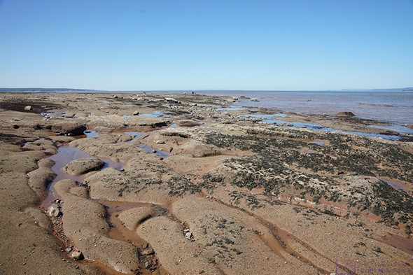
This is the view at low tide looking to the northwest from the platform and ledge that provide access to the ocean floor at Burntcoat Head Park. The land on the far horizon is still Nova Scotia, on the other side of Cobequid Bay and the Minas Basin.
Based on a tip we received in the Visitor Information Center at Peggy’s Cove, our main destination today was Burntcoat Head Park, on the south shore of the Bay of Fundy, specifically the west Cobequid Bay portion of the Minas Basin in the Bay of Fundy & Annapolis Valley tourist region. Before continuing, here’s a quick overview of Nova Scotia’s seven tourist regions:
- Bay of Fundy & Annapolis Valley – This might be the largest region in terms of area. Every part of Nova Scotia that touches the Bay of Fundy is in this region. We had already been to the Tidal Bore Interpretive Center in Truro, at the eastern tip of Cobequid Bay, when we first entered Nova Scotia many weeks ago. Up to Windsor, it is easily accessed from Truro and Halifax.
- Cape Breton Island – We spent enough time here to see the Cape Breton Highlands, drive the Cabot Trail, see a bit of the north shore of Bras d’Or Lake, and visit North Sydney. We did not see the west end of Bras d’Or Lake or the area south and west of North Sydney. North Sydney was our point of departure and return to/from Newfoundland and Labrador.
- Eastern Shore – This region includes the Atlantic Ocean shoreline from Halifax east to Cape Breton Island. It is punctuated by numerous inlets and dotted with islands and little villages. It is one of the more difficult parts of Nova Scotia to visit, and we were told that cell phone service is very spotty. We did not get a chance to find that out for ourselves on this trip.
- Halifax – This is largest city in Atlantic Canada, Canada’s major Atlantic Ocean port, and the only city considered to be major in national terms (population ~250,000). Within the context of Atlantic Canada, however, Moncton, NB and St. John’s, NFLB are also consider to be “major” cities. It sits at the boundary of the Eastern Shore and South Shore regions. We could easily have spent a week exploring Halifax. We only visited for one day, but saw the things that were top of our list. It’s a busy, congested place.
- Northumberland Shore – This region lies along the Northumberland Strait across from Prince Edward Island and runs from the border with New Brunswick to Cape Breton Island. It includes the cites of Pictou, New Glasgow, and Antigonish, and is considered the “Scottish heart” of Nova Scotia (New Scotland). We drove along and through it, but did get to spend time exploring here.
- South Shore – This region runs along the Atlantic Ocean southwest from Halifax to the southern tip of the peninsula. It’s home to Peggy’s Cove & Lighthouse, Mahone Bay, and Lunenburg. Like the Eastern Shore, it is punctuated with numerous inlets, bays, and coves and dotted with a few islands and quaint towns and fishing villages. It is more accessible, however, due to Hwy-103 and generally more tourist oriented, which means it also has good cellular service. We allocated one day to this region, and only got as far as Lunenburg, but it was a good day and gave us a sense of the region.
- Yarmouth & Acadian Shores – This region occupies a small portion of the southwest tip of the southwest peninsula, between the South Shore region and the Bay of Fundy & Annapolis Valley region. The main city is Yarmouth. It’s the most difficult region to get to (km and hrs) but our guide book said it’s worth the effort as this is “authentic” Nova Scotia that isn’t set up to please tourists. You can also get here by ferry from Bar Harbor, Maine.
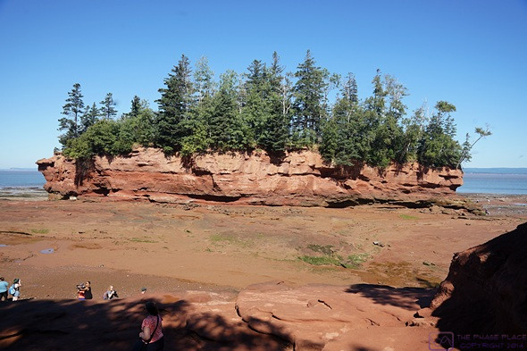
This is the entire island across from the access point to the ocean floor. The coloration was a clue as to how high the water would eventually rise. The island across from this access point is the key landmark for making sure you get back to the stairs to exit the floor before the tide comes in.
We knew before we left that we had not allocated enough time to explore Atlantic Canada, or even do just to a single province (although we did our best with Newfoundland). We are happy with the choices we made, but have also learned a lot and will be well prepared to plan our next visit(s).
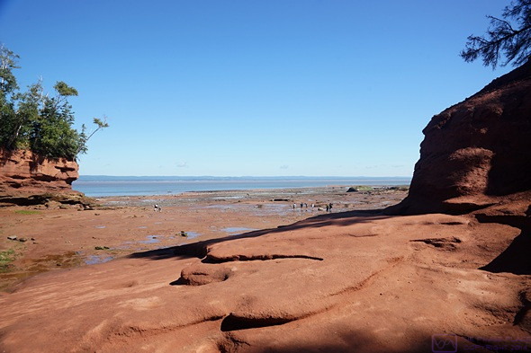
This is the view looking towards the northeast between the island and the mainland. The land on the far horizon is still Nova Scotia, on the other side of Cobequid Bay. Truro (not visible) is to the right at the far eastern end of Cobequid Bay.
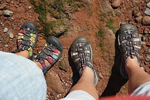
This is our feet, standing on the ocean floor at Burntcoat Head, Nova Scotia.
As for today, we had picked up a copy of the tide chart for Burntcoat Head at the VIC in Peggy’s Cove, so we new that low tide was at 11:05 and high tide was at 17:07. Burntcoat Head was almost due north of our campground. Most of our route was on secondary Hwy-354. We left a little after 10 AM and it took about 53 minutes to drive the 41 miles (~66 km), arrive just before low tide.
The following is from the Wikipedia entry “Burntcoat Head, Nova Scotia.”
“Burntcoat Head had a public wharf that has been the location of a tide gauge since the 19th century. The tide gauge at Burntcoat Head was operated by the Canadian Hydrographic Service and has recorded the highest tidal range in the world. Currently, the tidal gauge is no longer in operation. Tides at Burntcoat Head average 55.8 ft (17.0 m), with the highest being set during the 1869 Saxby Gale at 70.9 ft (21.6 m).
…
Like pretty much every place along the ocean around the world, Burntcoat Head experiences two high tides and two low tides each day. The Bay of Fundy fills and empties with approximately 160 billion tonnes of water twice a day. On average it takes 6 hours and 13 minutes between high and low tide. As soon as the tide has reached its lowest or highest point it will change directions and either begin to come to shore or flow back out. Each day the tides times will change approximately by one hour.
…
Burntcoat is a part of the Triassic Lowlands Region. The Minas Basin and Cobequid Bay was formed from rivers that eroded from the Bay of Fundy. Burntcoat Head shoreline and ocean floor is made from Triassic red sandstones and conglomerates.”
This large area to the east of the access stairs is empty now, but at high tide the water level will be part way up the bluff on the right.
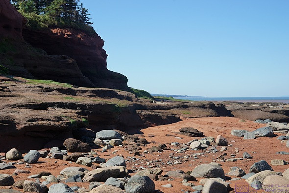
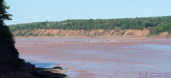
Part of the north side of the Island, looking west towards the Bay of Fundy. (It’s way off there, and it’s really big. The Bay is 400 km long and very wide at its mouth with the North Atlantic Ocean, but funnels down into long narrowing bays such as Cobequid, which is where the really high tides occur as the water piles up.)
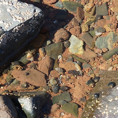
When the tide recedes, it leaves behind pools of water, from large to tiny. Every tide pool had living things in it, like this one. (The little crab, center right, was about the size of a Canadian quarter.)
The Wikipedia entry also mentions Burntcoat Head Commemorative Park and the replica Lighthouse, which is owned and operated by the Municipality of East Hants, but it does not mention the other main reason we sought this place out; we were able to walk on the ocean floor at low tide. (You can actually do this from ~3 hours before to 3 or more hours after low tide, as long as you remain aware of the time and what the water is doing. Other than injury from a slip/fall, the big danger is getting cut off from land as the tide comes in.) The Wikipedia entry also did not mention that this park is open to the public, free of charge.
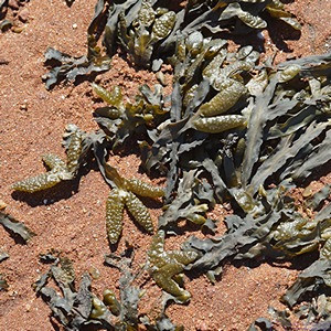
We found this seaweed all over the ocean floor, and thought it was particularly interesting.
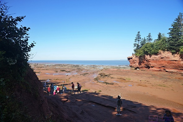
The Park had a nice gravel parking lot, a bathroom building (not pit toilets) and a gift shop in the replica lighthouse. A nice path led down to a wooden platform with stairs down to a sandstone ledge. From there we picked our way down using “natural” steps until we got to a place where actual steps had been carved into the sandstone for the last four or five feet to the ocean floor.
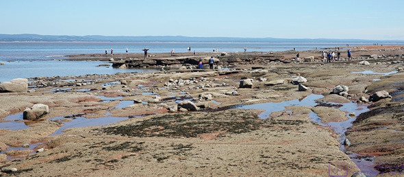
We stayed out for ~2-1/2 hours and took a lot of photos. We walked all the way out to the water’s edge, which I estimated to be about 600 meters (~3/8 of a mile) from the entry stairs. While we were at the water’s edge, Linda noticed rocks at the water line starting to disappear. We stepped back and watched the water level rise and move inland. We kept stepping back, and eventually retreated to higher ground to watch the details of the shoreline change right before our eyes. It was an amazing thing to witness. By 1 PM we were getting a bit hungry and worked our way back to the stairs.
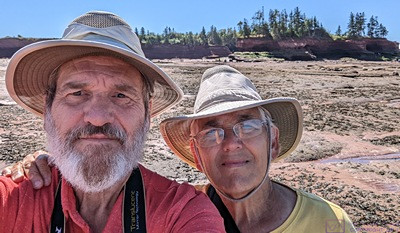
A selfie with the island behind us. The edge of the water is a little way in front of us.
Linda had packed a simple lunch of PB&J sandwiches, grapes, purple potato chips, and water. The Park had 8 picnic tables, but most of them were occupied, except the ones in the sun. We had our camping chairs in the back of the truck, and Linda suggested we get those out and use them. I carried them over to the picnic area and set them up in a shady spot while she brought the Styrofoam cooler.
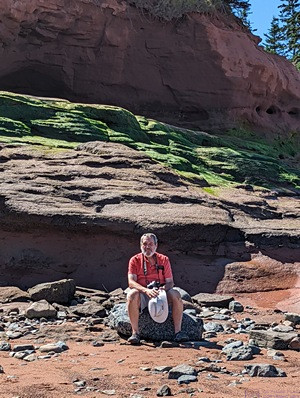
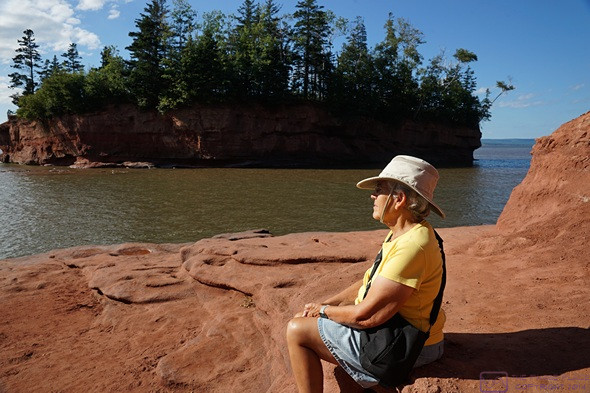
Bruce sitting on a rock in front of the north side of the island (facing the Bay). (Photo by Linda.)
We were done with lunch by a bit after 2 PM, packed up our chairs and cooler, and headed for the Fundy Tidal Interpretive Center in Maitland. The Center is a few kilometers east of Maitland, and it took about 30 minutes to drive there. We arrived at 2:50 PM to find a good-sized crowd of people standing on a platform at what used to be a pier for a long-gone bridge over the Shubenacadie River. It turned out that they were waiting for a tidal bore!
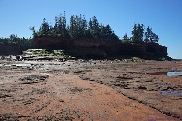
The entire north side of the island from hear the water’s edge. This island was once connected to the mainland by a narrow strip of land, and was the site of the original (1st of 4) lighthouse. The Fundy tides are very powerful and the sandstone of the Bay is constantly eroding.
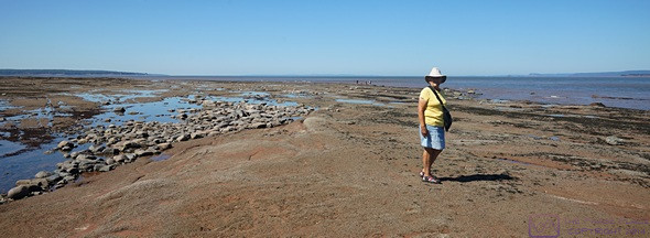
View to the west towards the Minas Basin, with Linda near the water’s edge.
A view to the northeast from the north side of the island. That’s still Nova Scotia on the other side of the Cobequid Bay.
We like these long, narrow channels, and noticed water starting to flow into them.
We had been standing in this area not 10 minutes earlier and moved back when saw the rocks start to quickly disappear under water.
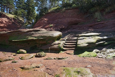
The last few steps to get onto the ocean floor, and get back off, were literally stairs carved into the sandstone.
The river is much larger than the Salmon River in Truro where we saw the tidal bore many weeks ago, and it did not produce a wave front, as such. But as the tide moved up stream, we saw the water start to churn, almost as if it was boiling, and eventually the water in the river was flowing away from the ocean instead of towards it. Afterwards, we spent a few minutes in the Information Center and then headed back to Burntcoat Head Park.
About 25 minutes east of Burntcoat Head was the village of Maitland, and about 5 minutes farther east was a bridge over the Shubencadie (Shoo Ben Ka dee) River. Just before the bridge was the Funday Tidal Information Center. The piers for the former bridge where still there, and the near shore one now supported a viewing platform. The Shubencadie flows north into Cobequid Bay near its mid-point. Like the Salmon River at Truro, it experiences a Tidal Bore with each high tide. Flowing from our right to our left when we arrived (towards the ocean) we got to watch the flow slow down and the water start to “boil” and then start to flow upstream. Kayaks and inflatables had followed the advancing tide water and appeared to our left playing in what looked like rapids from our vantage point.

A quote from Joseph Howe, a 19th century politician for Hants Country, regarding Nova Scotia and the Fundy tides.
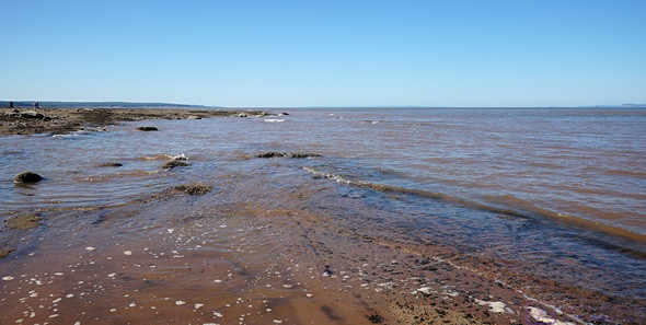
The reason for our return to the Park was to see and photograph the area where we had walked, only a few hours before, filled with 13.8 m (45.4 ft) of water. Low tide was clearly the more “interesting and unique” time to be here, but seeing the exact same place at high tide allowed us to understand the magnitude of this tidal phenomenon. Twice a day, the Bay of Fundy fills and empties 100 cubic kilometers of water weighing 160 billon tonnes. It’s a lot of water.
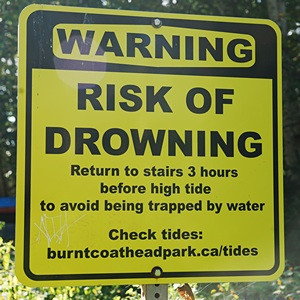
Like Peggy’s Cove, the Burntcoat Head Park access to the ocean floor is open to the public to use at their own risk. And there is risk, and there are warning signs explaining them.
Before going back down the access platform, we used the restrooms and ten spent a few minutes in the replica lighthouse which has a museum on the second floor. I also went up in the light room for a look at the view, but there was no ventilation and it was very hot. (The park was open until dark, but the restrooms and lighthouse closed at 5 PM.)
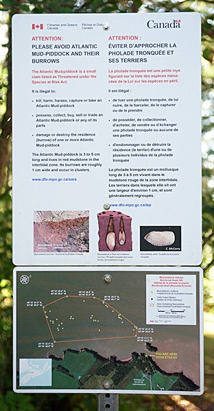
The area of the ocean floor to the west of the stairs is the habitat of an endangered species known as the “mud-pillock.” The staffer on duty at the entry platform re-stated all of the safety issues for every visitor, and specifically said the area to the west was “off limits.” No one walked in that direction, but we did see a few people who went around the east end of the island, down to the shoreline, and then headed west. Apparently, some people don’t think rules apply to them.
Seeing the bay filled with water was impressive, all the more so since we had been standing there just a few hours earlier. Unlike low tide, however, there wasn’t really anything else to do beyond looking and contemplating. The Park has viewing area to the west and claimed to be a good spot to watch sunsets, but that weas still about 3 hours away.
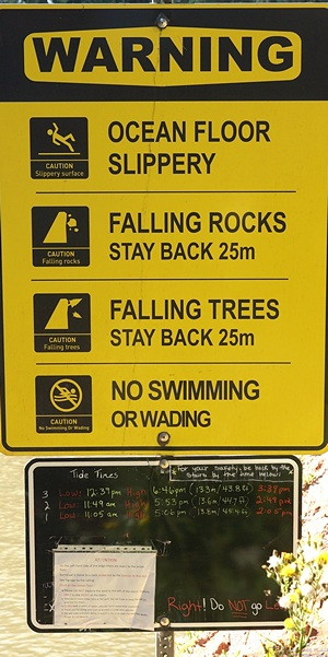
Yet another warning sign explaining the potential hazards of this site.
I got the photos the I wanted to show the change from low tide and high tide and, after sitting for bit and just looking at an amazing sight, we headed back to the truck for the return drive to camp. We took essentially the same route back, but went the other way (south) on Etter Road which saved a couple of miles and minutes.
Back at camp, it appeared that someone had organized a party and not invited us. The RV park was fairly busy, with lots of children running around and cars occasionally parked at the front of campsites and partially into the road. The kids were fine, the cars partially block the road, not so much. But it was fine. We relaxed for a while, having been on our feet for a good part of the day.
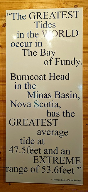
A sign in the lighthouse/museum building with the entry from the Guinness Book of World Records. (Photo by Linda.)
Linda made a nice salad for dinner, after which we went for a stroll around the park. Although we don’t appreciate folks cutting through our sites at RV parks, we are not those “grouchy old people” who don’t like children. We enjoyed our time as a camping family when our children were young, and we enjoyed seeing other families out doing the same thing now. We also took note of the fact that our site here (E07) was at the far end of our section, had relatively little traffic (pedestrian or RV) and was relatively quiet compared to the party central section by the bounce pad and ice cream shack.
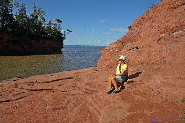
Linda sitting on a higher level of the entry ledge at high tide. Compare to an earlier photo. The water is just below the edge of this platform and is half-way up the side of the island. That’s a lot of water in the space where we were standing just hours earlier.
I spent the rest of the evening writing and processing photos while Linda continued to read her current book. We chatted a bit about our plans for tomorrow and came to the conclusion that we would probably just hang around camp and take it easy.
A view of Cobequid Bay to the northeast. The ocean floor where we were walking around has disappeared under 45+ feet of water. Linda is looking northwest towards the Minas Basin.
…