WEDNESDAY 27 July
(Note: These photos are in order, but do not necessarily match the text that flows around them. That’s why pictures have captions.)
I was up early enough to upload the blog post for yesterday, make a cup of coffee, and feed the cat. When Linda got up, we had raisin toast for breakfast. Simple, but effective, as we had a long day ahead of us.
Today was devoted to (almost) circumnavigating the northern part of Cape Breton Island clockwise on the Cabot Trail. We left at 8:11 AM and headed back down Hwy 105 (the Trans-Canada Highway) past Baddeck and picked up Hwy 30, the (unofficial) starting point for the Cabot Trail loop near Nyanza.
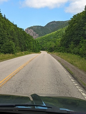
The Cabot Trail (Hwy 30) headed north along the west coast of Cape Breton Island, Nova Scotia (photo by Linda).
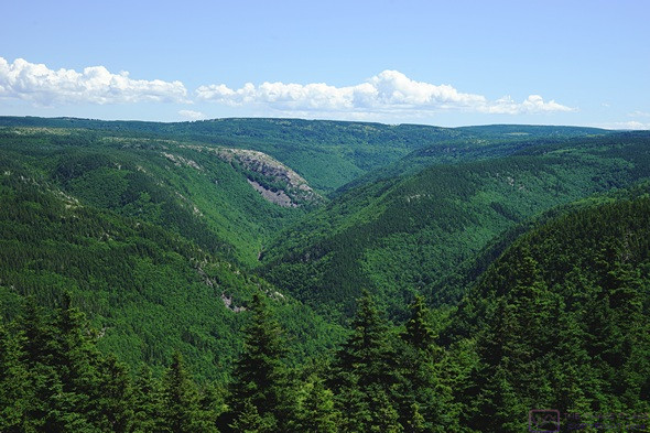
For context: The entire trail is a 298 km (~ 186 mile) loop road with a total elevation gain (uphill climbs) of over 17,600 ft. (~ 5,415 m) and is used by motor vehicles and bicycles. At its northern end, a portion of the trail passes through, or along the edge of, Cape Breton Highlands National Park. The road is two lanes except for an occasional turn or passing lane, and the shoulders are often narrow or non-existent. This made for fun getting around the bicyclists, who were numerous. Major portions of the road are posted at 80, 90, or 100 km/hr, but slowdowns to 70, 60, or to km/hr are common, with even slower speeds on hairpin turns. The road surface is fabulous in some places and very rough in others, so you can’t always travel comfortably at the posted maximum speed limit. The road is rarely straight or level and has some dramatic sections with 12% grades and switchbacks. Grand views are found all along the trail, and there are scenic turnouts (lookoffs) to fully enjoy the views. They were always in use.
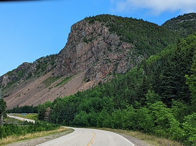
There are a lot of large cliffs along the Cabot Trail. Some of them plunge into the sea (but not this one). (Photo by Linda.)
Before we had gotten very far to the northwest, we encountered a road closure and had to follow a posted detour. The detour turned out to be quite some distance on a narrow, twisty, 2-lane road that was being completely rebuilt and involved flaggers and escort vehicles for traffic control. At one point the lane that was open to traffic was dirt. We were glad to have the FX4 (off road) version of the F-150.
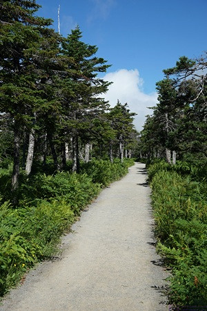
The beginning of the Skyline Trail (after the parking lot)., Cape Breton Highlands Natl Park, NS. A good gravel trail with very few trip hazards. The trailhead is at ~ 1,300 ft. ASL.
Not knowing how much more of this kind of stuff we might encounter, the detour felt like a bad omen, but it was a beautiful drive otherwise and, as we got deeper into Cape Breton Island and the Cape Breton Highlands, we imagined that it must be similar to driving through the Scottish Highlands with high, steep hills plunging into lakes of unknown (to us) depth. Once we made it to the west coast of the island, Hwy 30 followed the shore to the northeast. It was very different from the east coast we had driven with Paul and Nancy when we first arrived on Cape Breton Island. The land between the sea and the hills was broad and relatively flat with few trees. It made for open feeling with good views all around.
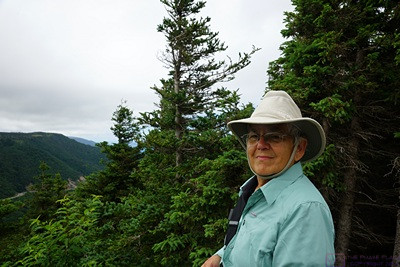
Linda on the Skyline Trail, Cape Breton Highlands Natl Park, NS
Just beyond Cheticamp we saw a sign for the Aucoin Boulangerie & Bakery in Petit Etang and pulled in to the already crowed overflow parking lot. For being a small place in a small town, the line was out the door. It probably helped that they sold sandwiches to go, and were right on the highway just before it turned and climbed up into the National Park. We surmised that locals and repeat visitors to the area were already well-acquainted with this place. We splurged and each had a blueberry turnover. And yes, they were yummy.
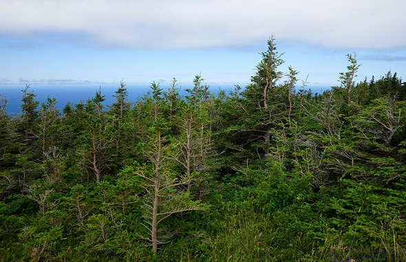
The open forest along the Skyline Trail in CBH-NP. A budworm infestation in the 1970s killed large areas of Balsam Fir, allowing Birch trees to flourish. A favored food of Moose, they flourished as well, alternating the forest in the process and preventing it’s regrowth.
The National Park is a gem, with numerous hiking trails and campgrounds. Our specific interest for today was the Skyline Trail on the western edge of the park. This trail is rated as easy and relatively flat. As we have learned, that does not necessarily mean we would agree with that characterization. AllTrails describes it as “a 4.9 mile heavily trafficked out and back trail located near Cheticamp, Nova Scotia, Canada that offers the chance to see wildlife and is good for all skill levels. … Route Type: Out & Back; Length (total): 4.9 mi (~ 7.9 km); Elevation Gain: 633 ft. ( ~ 195 m); Difficulty: Easy. Yah, right.
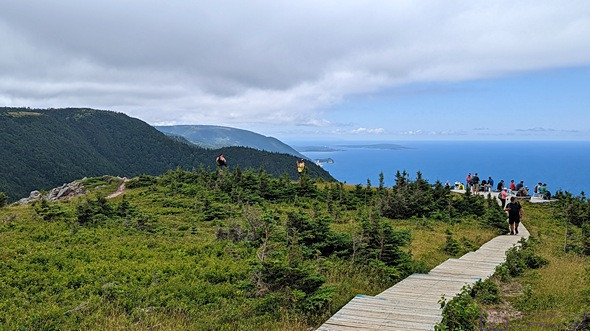
The Boardwalk (and giant staircase) at the end of the Skyline Trail. The last several hundred feet go down the face of a cliff by a couple of hundred feet. No photo of that. (Photo by Linda.)
We didn’t see any wildlife, but we did see a LOT of people on the trail. And that was OK. It was nice to see people out being active and a National Park getting the attention it deserves. Besides, it was a nice day for hike through a forest, with the temperature in the upper 70s F and cloud cover, at least initially. And the hikers just naturally spread out along the trail.
The end of the trail is a boardwalk and towards what we thought was the end, it cascaded down the side of very steep cliff for another 200 feet. We overhead another hiker say to her party “do I get a sticker or a medal if I walk down there and back up? Because if not, I’m staying here.” We concurred with her thinking on this matter as we did not see any amazing photo opportunities arising out of the additional time and effort. For that matter, the Skyline Trail had a loop section, in case we wanted to make it an even longer hike. We didn’t, and started back the way we came after spending time admiring the views and taking some photos.
A experimental reforestation area along the Skyline Trail. It covers an area equal to 9 football fields and is fully enclosed by a Moose proof fence with gates to allow hikers through. (The fence is visible in the right side of the frame near the center.) The gates do not reach the ground, so smaller animals have access to the area.
From this point, the Cabot Trail (Hwy 30) ran north to the McKenzie River Valley and then dropped from the highlands to the sea on a 12% grade with switchbacks, before finally turning east, crossing the McKenzie River and entering Pleasant Bay. It then traversed the northern reaches of the park eastbound over to Neils Harbor. We encountered one other construction project, this one in the park, but it was short and didn’t take much time to get through. But before doing all of that, we ate the BP&J sandwiches that Linda had packed and had a few Fritos. We brought water this time, and actually drank it.
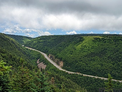
A view of the McKenzie River Valley from a lookoff along the Cabot Trail.
From Neils Harbor down to Salty Rose’s & the Periwinkle Cafe, just north of Ingonish, the road and scenery were still new to us. The café was the northern extent of our previous drive on the Cabot Trail. We had a nice lunch there last time, but today we just drove by. The scenery and road from this point south were just as nice and interesting as the first time, but we did not feel compelled to stop at scenic pullouts (lookoffs).

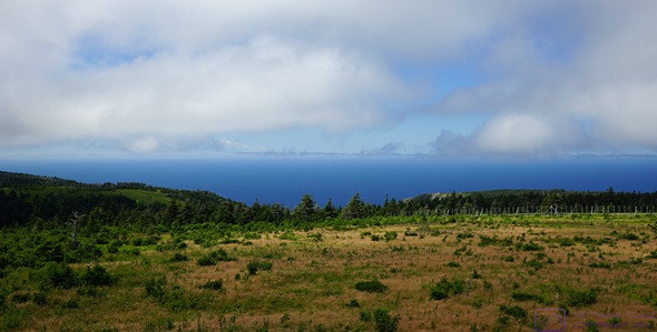
A view of the Cape Breton coastline looking north from the McKenzie River lookoff of the Cabot Trail.
We got back to camp around 5 PM, although this included an extra 40 minutes to drive about 24 km round-trip in towards North Sydney on the T-CH, refuel the F-150, and return to camp. Start-to-finish, it was a 9-hour day and we traveled at least 200 miles. If you are able to arrange your travels accordingly, it probably makes sense to take two or more days to do the Cabot Trail in a point-to-point fashion as there are campgrounds for tents and smaller RVs, as well as Inns, rental cottages, and other forms of lodging for non-campers. Fuel is available, and there are quite a few restaurants. Grocery stores, however, are not one of the Cabot Trail’s strong points.
We finished the vegan chorizo for dinner and then I got to work processing photos and writing this post. By 10:15 PM the temperature had dropped. Before closing the trailer door for the night, I went outside to check the sky. The air was crisp, the sky was mostly clear, it was dark enough for all the major stars and constellations to be visible, and I could make out the Milky Way, albeit very faintly. Tomorrow begins a new phase of our adventure; our first time putting the Airstream on a ferry, and our first trip to Newfoundland. But more on that in a subsequent post.
…
Bruce and Linda
Really enjoy reading your stories about the trip. Almost as if we were there with you. You are an excellent writer Bruce. I take it you are a pro now at hooking up and unhooking the trailer. It really sounds like you are enjoying what you are seeing. Enjoy the rest of your trip and keep up the stories.
Bill and Karen
Thanks! Glad you are enjoying it. Atlantic Canada is a very scenic place, and the people we’ve met have been wonderful. We just arrived in Channel-Port-aux-Basques Newfoundland & Labrador early this morning (Friday, 29 July 2022). The Marine Atlantic Ferry was really something. Big post coming up on all of that very soon. What we have seen of Newfoundland so far is amazing. ~Bruce