TUESDAY 30 August
(Note: There are 17 photos in this post, spread throughout the text.)
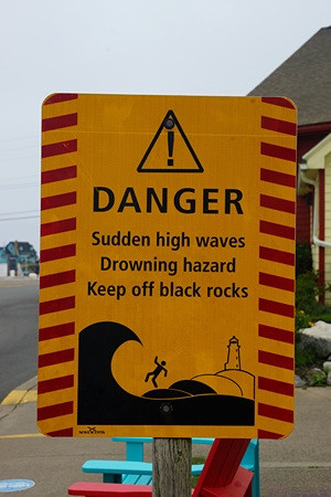
The ATVers we met at Channel-Port-aux-Basque, Newfoundland, were from Halifax and warned us about the “Black Rocks” at Peggy’s Cove. We arrived to find lots of signs warning of this specific danger. I can’t imagine coming to such a beautiful place and dying as result of my own stupidity, but it apparently happens several times every year.
Today was the penultimate day of this August, and we were eager to start exploring this part of Nova Scotia. Since heading south from Truro towards Halifax yesterday, everything we saw was new to us. As we have found throughout Eastern Canada, the Provinces are subdivided into named regions. These regions are not governmental but rather for tourism, and Peggy’s Cove is the starting point for exploring “The South Shore” region of Nova Scotia.
The day started out heavily overcast but with no threat of rain. We spent some more time studying our maps and Atlantic Canada guide book and then settled on a plan for the day. After our usual morning chores, coffee, and a light breakfast, we got ready to go sightseeing.
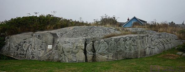
Finnish-born artist William deGarthe’s 30-meter (~98 ft) carving depicting the fisherman, families, and lives of Peggy’s Cove. This was carved into an exposed granite rock adjacent to his studio. He started the carving in his 70’s, and it took him 8 years to finish.
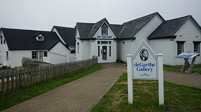
William deGarthe’s studio / art gallery. It was not open during our visit. He is known for his nautically themed oil paintings which, according to our guide book, “grace galleries the world over.” We did not see any images during our visit to Peggy’s Cove.
Our route took us back down Hwy-101 to Hwy-102 towards Halifax and along its western edge to Hwy-103, which headed southwest along the South Shore (but not right by the water). We eventually left Hwy-103 for Hwy-3, “The Lighthouse Road.” As we had seen in Newfoundland and Cape Breton Island, scenic routes have names. Provinces also have mottos, and Nova Scotia’s is “So Much to Sea.”
Hwy-3 was slower and curvier, as it hugged the coast and went through the small villages that dot the shoreline along the south shore of the Atlantic Ocean. Indeed, the bays along this coast extended deep into the land, often with small fingers at their furthest ends that provided safe harbors.
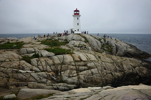
The lighthouse at Peggy’s Cove is still a functioning aid-to-navigation.
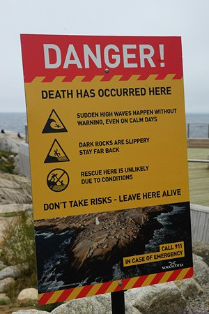
Another reminder that (careless) people have died here.
Peggy’s Cove is a small, working fishing village that is famous for its Lighthouse and surrounding rocks. The lighthouse is Atlantic Canada’s most photographed site. It appeared to also be Atlantic Canada’s most visited site.
The Visitor Information Center parking lot had 105 spaces, most of which were occupied, but we managed to find an open one, and it was big enough for the truck to fit comfortably. Vehicles were also parked on the street anyplace they could do so legally. There had to be at least 150 personal vehicles (and a few RVs) in town. Even at a modest average of 2 people/vehicle, that was over 300 people. The tour buses were parked in their own area behind The Sou’wester restaurant and gift shop up by the Lighthouse. We counted nine buses, with a combined capacity for over 500 people. My rough estimate was 700 – 1,000 tourists in town, but there was room to spread to (except in the gift shop), so we did not feel (too) crowded. The weather was also still overcast , so I was not going to get any “post card” photos here today.
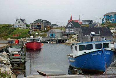
Peggy’s Cove is a working fishing village and the small harbor looked like it was all business.
There was a restroom building at the VIC, which was much appreciated. In the VIC, we were studying a map on the wall and one of the staff came over to offer assistance. She was great. By the time we left we had maps and brochures and lots of suggestions based on local knowledge.
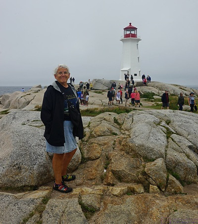
Linda at the Peggy’s Cove lighthouse, proof that we were there.
The Lighthouse was nice, but not unusually unique or impressive. The setting, however, was spectacular (a word I probably use too often, but the other choices are “amazing” and “awesome,” so …) and probably the reason it’s the most photographed site in Atlantic Canada.
We did not quite feel that vibe, but perhaps we would have on a nicer weather day with blue skies and puffy clouds, or during a sunrise or sunset (the guidebook says to visit before 9 AM or after 5 PM to avoid the crowds), or during a storm with angry clouds and waves crashing against the shore. The site certainly had the potential for all of that.
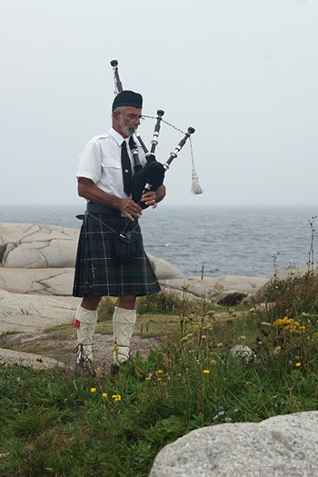
This guy strolled onto the rocks in full regalia carrying a wooden case. I guessed, correctly, that it contained a bagpipe. He put out a tip jar, and played for the crowd. We saw this a few times in Nova Scotia, and never tired of it.
We were, of course, still in “New Scotland,” so we were not surprised when a distinguished looking gentleman walked out onto the rocks, got out his bagpipes, and started playing for anyone who cared to listen. Not like it was a choice; when bagpipes are playing, you are going to hear them. But that was not a problem for us. We love hearing bagpipes, and we love that the players, at least in this part of Canada, always wear appropriate/correct Scottish Highlander clothing when doing so.
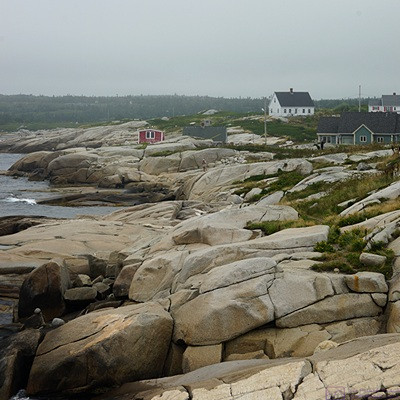
Part of the reason Peggy’s Cove is so beautiful, and so dangerous.
Part of the beauty of Peggy’s Cove Lighthouse is that the rocky headland on which sits is completely open down to the ocean. There are no fences, ropes, or barricades to prevent slips and falls. Other than an observation platform by the Sou’wester restaurant, and a short concrete path onto the rocks, the site is potentially dangerous for the inattentive and foolish.
Post cards, of course, always show places like this with deep blue skies or stunning sunsets, but the reality is that this place faces the North Atlantic Ocean, and experiences many types of weather. Overcast is just one of those types, and it always sets its own mood, which is what I tried to capture.
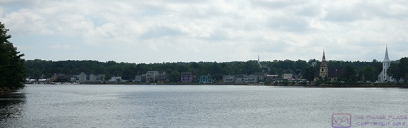
A view across Mahone Bay as we approached the village, with the three church spires clearly visible.
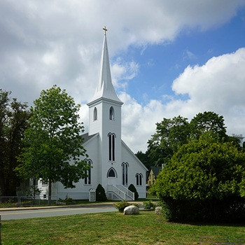
Mahone Bay is known for its three churches. This is St. James Anglican.
Moving on from Peggy’s Cove, we continued to follow the edge of St. Margaret’s Bay as far as it’s northwest corner. A peninsula separates St. Margret’s Bay from Mahone Bay to its west, but we skipped the drive along its coastline on Hwy-329. As the Bay came into view from its northeast corner, we saw the three church steeples, and pulled off into a small look-off parking area for a photograph. When we reached Chester, at the north end of Mahone Bay, we parked and walked around a bit.
Chester is known for its three churches, two of which are on/near the harbor, and the parking lot we used is across the street from them. We had seen some very nice housing all along our drive, and Chester appeared to be a somewhat more upscale community. The Bay certainly had plenty of sailboats at anchor, more than we had seen anywhere else the entire trip.
We continued on Hwy-3 along the coast of Mahone Bay and finally arrived in Lunenburg. Lunenburg is, apparently, a big deal on The South Shore, and judging by the number of cars and pedestrians, lots of people think so.

St. John’s Lutheran Church, Mahone Bay, Nova Scotia.
To its credit, Old Town Lunenburg is a UNESCO World Heritage Site. It’s built on a peninsula with a high ridge running down the center lengthwise. A series of streets march up the southwest slope, parallel to the shore of Lunenburg Harbor, with steep streets cutting across every so often. The streets were lined with historic buildings, most of which had been repurposed (of course) as shops or restaurants. It was very walkable, albeit with serious verticality, and lots of people were doing so.
Linda had found a place for us to eat (Salt & Bait) in Lunenburg with a few vegan options, but their website said it closed at 3 PM and reopened at 4 PM. We got to Lunenburg just after 3 PM, so we explored the town first. But first we had to find a place to park. Part of the charm of the place was negated by the vehicles parked almost bumper to bumper along both sides of the roads. And all of the spots had parking meters. There was a public parking lot at the northwest end of the waterfront street. It had an entry gate, but no information was displayed about the cost or how to pay. Free street parking was, however, outside the historic district. Not tourist friendly, IMHO, but perhaps that’s the price of success that comes with the UNESCO World Heritage Site designation . A bit away from the Historic Old Town, we found a spot on the street that was free. As a bonus, it was near the start of the Harbor Path that took us on a short walk past an old Cemetery and into the historic district.
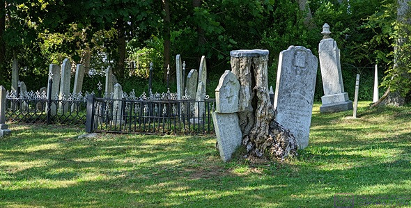
We walked past this old cemetery on the way into Lunenburg, Nova Scotia. One of the things I like about old cemeteries is the less orderly placement of the graves and headstones.
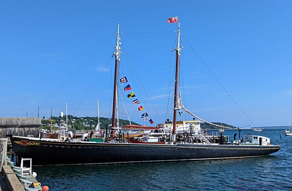
The Theresa E. Conner is a 2-masted schooner in the style of the Bluenose and Bluenose 2
We strolled along the waterfront and eventually came to the Maritime Museum and the Theresa E Conner schooner. The Bluenose II, a recreation of the original/famous Bluenose, was not in the harbor this day. At the far end of the Harbor, we saw the Picton Castle, a 3-masted, square-rigged sailing vessel which is part of the Nova Scotia Sea School based in Lunenburg.
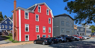
Like many seaside villages, many of the buildings in Lunenburg were painted in vibrant colors. (Pastels are not used here like they are in the Caribbean.) I never found a viewpoint that I liked for a photo, due to the cars and wires. There were a lot of restaurants and shops here, and it felt more touristy than charming.
At 4 PM we made our way to our restaurant of choice, only to find that it was closed today. Arrrgh. There could be lots of reasons for that, of course, but we did not appreciate that the website said it was open, and there was no further explanation as to why it was closed. Plan B was “J3 Pizza” which we had passed on our walk into town.
Besides pizza, they had a full Lebanese menu, so we knew we could get something to eat there. We ended up getting a 12” thin crust gourmet veggie pizza, no cheese, and cold tea. It was an OK meal.
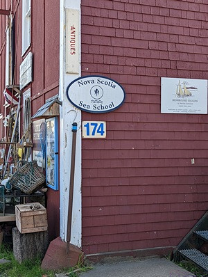
The old red building by the Picton Castle was the home of the Nova Scotia Sea School as well as a place to shop for antiques.
Lunch concluded, we were done with Lunenburg, at least for this visit. We programmed the navigation system in the F-150 for the “shortest” route which, once again, tried to do some peculiar things. But it’s just an algorithm that is trying to find the absolute shortest mileage between the two specified points, and that often seems to lead to some otherwise peculiar routing decisions. From Lunenberg we got on Hwy-103 as directly as possible. Hwy-103 is the fast route through The South Shore, running parallel to the coastline and farther inland than Hwy-3, and skipping most the peninsulas and most of the towns and villages.
We took Hwy-103 all the way to Exit 5 for Hwy-213 to Lower Sackville. This wasn’t designed to save us time but, rather, to avoid having to take Hwy-102 along-side Halifax to Hwy-101. In a stroke of positive karma, there was a shopping plaza at the exit with a Sobeys Extra supermarket! Even though we did not have list, we stopped and picked up a “few” things.
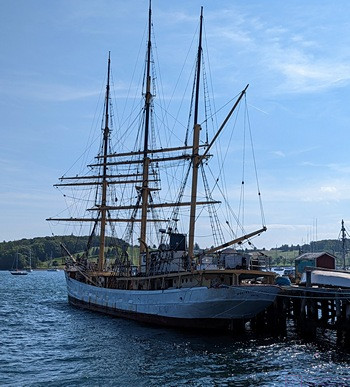
The Picton Castle is a square-rigged, 3-masted schooner used for training and based in Lunenburg. When sailing, it has a professional crew of 12 and up to 40 trainees. It has been around the world many times. It was possibly still in active use, but looked like it had seen better days.
We were back on Hwy-213 by 5:30 PM. It did not intersect Hwy-101 but went under it and ended at Hwy-1. Perfect; the Halifax West KOA was on Hwy-1. In spite of rush-hour traffic, we were back at camp before 6 PM.
Still full from our late lunch, we passed on dinner, but finished off the Black Tower Rivaner wine and had “So Delicious” vegan ice cream bars. That was a treat, as we have not had non-dairy ice cream on this trip nearly as often as we might have it at home (which isn’t all that often) . We spent the rest of the evening, as we often do, reading, working puzzles, editing photos, writing, and talking about our plans for the next day. It had been a long day, and we were both a bit tired, so bedtime came a bit earlier than normal.
…