2015/04/04 (S) Gila Cliff Dwellings
We decided to visit the Gila Cliff Dwellings National Monument (GCDNM) today. It is only 94 miles from Deming but it is a 2.5 – 3.0 hour drive. From Deming we took US-180 to Silver City where we picked up NM-15. NM-15 is placarded as a “mountain road” and crosses the Continental Divide as it runs through the Gila Wilderness to the little town of Gila Hot Springs and then on to the GCDNM where it ends. It is marked in our road atlas as a scenic road and it was all that and more. The road itself was an adventure and afforded a range of experiences from dense forest to switchbacks and hairpin turns to distant views as it ran along mountain ridges. We took our time and enjoyed the ride, stopping to take a few pictures along the way
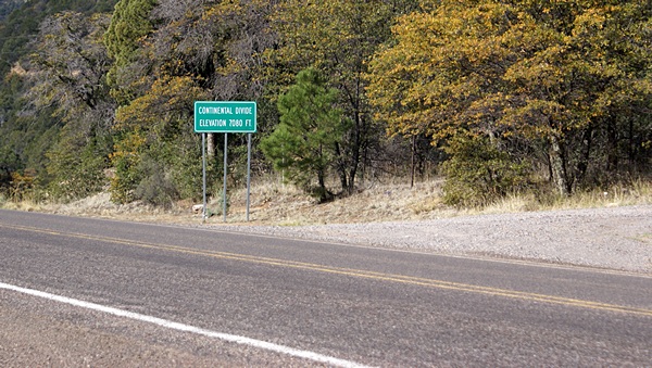
We crossed the Continental Divide twice today. This was the crossing on NM-15.
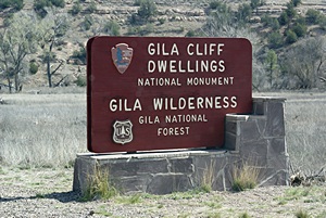
We eventually reached the GCDNM Visitor Center where we obtain more information about the Gila Wilderness area, the Monument, and the ancient cliff dwellings. The cliff dwellings are in a canyon about two miles from the Visitor Center. A road leads from the Visitor Center to a parking lot at the mouth of the canyon. A ranger gave us an interpretive trail guide and quick overview of what we would see and what would be required to see it. It turned that we were not in the Monument yet. We started up the trail by crossing over a small stream on a foot bridge and on the other side actually entered the Monument, which is only about 600 acres. The Monument, however, is surrounded by the vast and remote Gila Wilderness, so the Monument is there specifically to protect and manage access to the cliff dwellings.
The trail wound up the south side of the creek that runs through the canyon to a point beyond the cliff dwellings, which are all built into natural openings in the south-facing north wall of the canyon, before crossing to the north side of the creek. The trail was good, but fairly rugged; definitely not a place for wheelchairs or flip-flops. It also afforded some views of the cliff dwellings. Once on the other side of the creek the trail climbed steeply and was narrow with steep drop-offs at a few points. By the time we got to the first of eight compounds we felt like we had earned the right to see them.
There are three aspects to the Gila area with cooperative management.
The Gila cliff dwellings are very accessible once you get up to them allowing a close up look at these fascinating remnants of an ancient way of life. One of the things we learned is that the term Anasazi, which translates roughly as “ancient enemy” is no longer being used to describe the people and culture that inhabited this area until sometime around 1300 AD and built these dwellings. The accepted name is now Ancient Puebloans, which more clearly establishes the nature of how these people lived and maintains a connection to the Native Americans who still inhabit the southwest U.S. and northwest Mexico, many of whom claim direct descendancy from these ancient people. We enjoyed our visit to GCDNM and felt it was more than worth the drive.
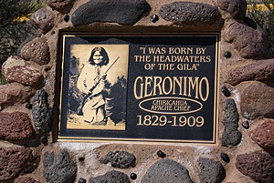
Native American leader Geronimo and his people lived in this area.
NM-15 to GCDNM is a dead end road so some backtracking is necessary on the return trip. We like to see new things so south of Gila Hot Springs we took NM-35 through Mimbres, back across the Continental Divide, and down to San Lorenzo on NM-152 which we took back west towards Silver City. Much to our surprise we came upon one the Chino Copper Mine and pulled into a fenced public viewing area on the highway. Chino is still an active open pit (strip) mine and is an almost incomprehensively large whole in the ground. After trying to take a few photographs we continued on and took a small side road to Bayard and US-180 and returned to Deming.
We did not get back to the SKP Dreamcatcher RV Park in time for the start of happy hour at 4 PM but we did make it back in time to socialize a bit with folks before everyone went back to their rigs for dinner. We struck up a conversation with Rick and Mary who had just arrived today.
2015/04/05 (N) Deming to Alamogordo
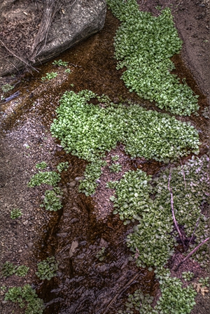
An HDR image of some lovely green plants on the hike up to the Gila Cliff Dwellings.
We were up at 7 AM, and a light breakfast, straightened up the bus and took showers. I ran into Chris Baby in the men’s room (that’s his name). I met Chris at the recent Escapade at a couple of the Xscapers social events. He is one of the new generation of 20-somethings that is giving full-time RVing a serious try. I find it fascinating and refreshing to meet this new generation of RVers. We hooked up the car and used the restroom by the office one last time. Linda then called the Desert Paradise MH & RV Park in Alamogordo and they said there was plenty of space and we did not need a reservation. We visited briefly with fellow RVillage, Rick and Mary, whom we met at happy hour last night. They had checked our RVillage profile and discovered that we were also fellow Freethinkers. That would not have happened without RVillage.
I had been indicating in the last few posts that we were headed to Albuquerque, New Mexico from here, and we were actually planning on finding an RV Park closer to Santa Fe. We changed our minds and decided to visit a friend in Alamogordo, New Mexico and see the sights around there before heading to an RV Park about 20 miles east of Albuquerque. We had targeted an 11 AM departure but we were ready to go before that and pulled out around 10:45 AM.
The drive over I-10 east to I-25 north to US-70 was smooth and uneventful. US-70 going east from I-25, however, climbs steadily heading out of Las Cruces and then very steeply for several miles before topping out. It then drops steeply for many miles into the Tularosa Basin and through the White Sands Missile Test Range. Once down to the valley floor the road is level across the range running past White Sands National Monument, Holloman Air Force Base, and into Alamogordo, New Mexico.
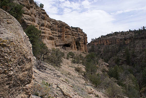
The westernmost of the Gila Cliff Dwellings.
We did not have any difficulty finding the Desert Paradise MH & RV Park or getting in and parked. The park uses a self-registration process (Iron Ranger) for short-term guests and there was only one rig in the short-term area so we had our pick of sites. Linda took care of registering us while I connected the shore power and took care of the rest of our exterior/systems arrival routine.
The park has a conveniently located building with two bath/shower rooms, a laundry, and a central club house room with a kitchen in one corner, TV viewing area in another corner, and a library with sitting area in another corner. I happened to meet the park manager, Wes, while I was in the building and Linda obtained the Wi-Fi password from a women in the laundry. We connected our WiFiRanger to the Park’s “N” signal and it was solid and fast; as good, or better, than what we normally see with our Verizon Mi-Fi.
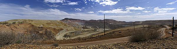
A panoramic photo of the open pit Chino Copper Mine near Silver City, New Mexico.
Although the drive from Deming to Alamogordo was short, both in terms of miles and time, it was hard on the bus and on us so we decided to stick around the coach and rest. That also gave me a chance to continue working on blog posts and related tasks. Before settling in to my work I called Butch and got Bell’s phone number and gave her a call. She was very excited that we were in town and we arranged to meet up with her tomorrow morning.
2015/04/06 (M) White Sands Natl Mon
Bell arrived at our campsite at 8 AM. We cleaned out the back seat of our Element and found space for a small cooler and three disc sleds. We gathered up our stuff, loaded it wherever it would fit, and headed to White Sands National Monument (WSNM) about 13 miles southwest of Alamogordo. The white sands are a unique natural phenomenon. The WSNM shares management responsibilities with the White Sands Missile Test Range. The Tularosa Basin is the birthplace of U.S. efforts and the first atomic bomb every exploded was detonated at the Trinity site on the north end of the test range. This part of New Mexico, with its Puebloan ruins and nuclear facilities is a place where ancient and modern meet and somehow coexist.
We drove the loop road through the dunes twice, stopping at different places to climb, photograph, and slide down on the disc sleds. The loop road is not paved but, rather, is plowed to keep it open. WSNM is interesting and different from most National Monuments in that visitors are encouraged to “play” on the dunes. There are many very large parking areas, picnic areas with sun shelters, a horse staging area, and places where the park rangers hold programs and lead walks. You can hike out into the dunes and you can even backpack/camp in them (after registering and getting a permit). This use is permitted because the sands are still being formed and constantly restoring their natural appearance as the move across the floor of the Tularosa Basin. They are a slow but powerful and persistent force of nature; unique and wonderful to experience.
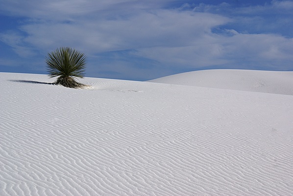
Almost as amazing as the white sands are the things that manage to grow in them. The sands eventually obliterate everything in their path.
The Visitor Center was not open when we arrived so we stopped on our way out. We watched the film that was running, stamped our NPS Passport, and then wandered around the gift shop but did not buy anything. We then drove back towards town and pulled into the Visitor Processing Station for Holloman Air Force Base.
Bell retired from the U. S. Air Force after 20 years of service, so she has access privileges to Base and its facilities. There is a food court in the Base Exchange building and we ate lunch there. The commissary and other community facilities were also located in that area but we did not go in any of them. We went instead to the see the static display of aircraft that have been based at Holloman AFB over the years. Holloman is a Tactical Air Command (TAC) base, and the 49th fighter wing has flown many different jets over the years, including the McDonnell Aircraft F-4 ‘Phantom’ and F-15 ‘Eagle’, both of which my father helped design (structural engineer). More recently the YF-117 Stealth fighter was based here and the wing currently flies the F-22.
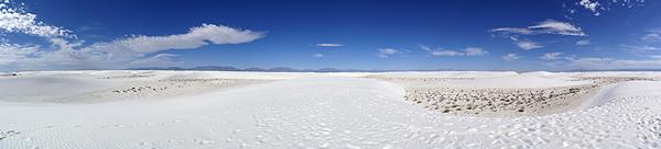
A panoramic photo of part of the White Sands National Monument. The loop road only goes through a small portion of the dunes.
Bell, and her husband Jim, were stationed at Holloman 17 years ago when they retired. The liked Alamogordo and decided to stay. They own/operate the local cab company (Dollar Cab) which provides transportation services locally and also travels as far as Albuquerque to get people to/from medical facilities and care providers. They also own Moore’s Auto, a used car sales and automotive service business that is now run mostly by their son.
We were back at our bus by 2 PM and arranged to pick Bell up tomorrow morning at 8:45 AM for another day of sight-seeing in and around Alamogordo. Being back mid-afternoon I had some notion that I would get a lot of work done on our blog but it was very warm in our coach as we had to leave the roof vents closed due to the strong winds. We were also both feeling a bit ‘off’ due to the heat and the larger-than-usual lunch we ate, so we turned on the air-conditioners and took naps.
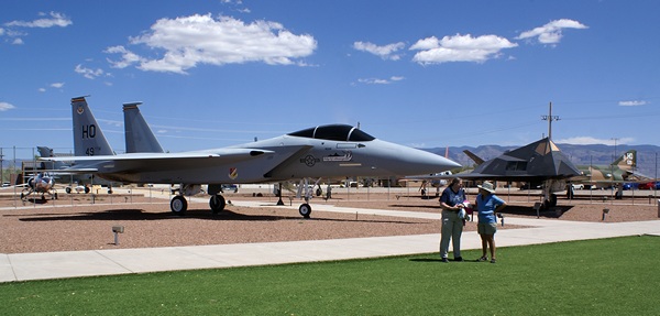
Bell and Linda in front of an F-15 in the static display area at Holloman AFB.
When we got up an hour later we felt better and Linda started researching the U. S. Army Corps of Engineers park at Cochiti Lake north of Albuquerque. She downloaded and activated Google Earth Pro (GEP) and started looking at routes. One of the nice features in GEP, which is now free, is the ability to plot a route and get its elevation profile. We both got involved in looking at possible routes out of the Tularosa Basin (I already had GEP installed on my laptop) and discovered that the only way out that did not involve significant up and down grades was south to El Paso, Texas. We did not enjoy the drive through El Paso in December and it was the opposite direction from where we want to go. We had planned to take US-54 north to US-380 west to I-25 north to Albuquerque /Santa Fe but changed our mind when we saw that US-380 is not a designated truck route and has one section with a 10.8% grade (climbing) going west. Santa Fe is also above 7,000 feet so we started looking for RV park options near I-40 east of Albuquerque.
We had the leftover seitan mock stroganoff for dinner. Linda found a PBS station and we watched Antiques Roadshow. She went off to bed to read and I compiled another blog post and uploaded it before turning in.