2015/04/07 (T) Space Nuts
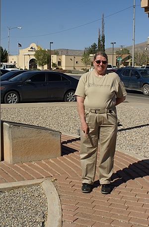
Our friend and Alamogordo tour guide Bell Moore, points to her Gulf War service brick at the Alamogordo, NM Chamber of Commerce.
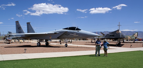
We have always been intrigued by outer space and the human desire to go there and learn about the universe so in that sense we probably qualify as “space nuts.” Indeed our first destination this morning, after picking up Bell at her house, was the New Mexico Space History Museum near the New Mexico State University Alamogordo campus at the northeast corner of town.
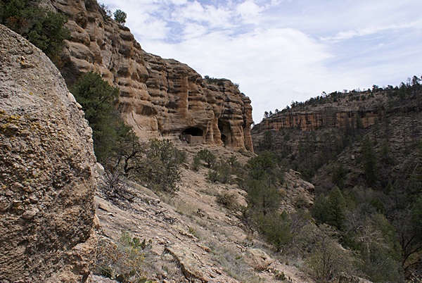
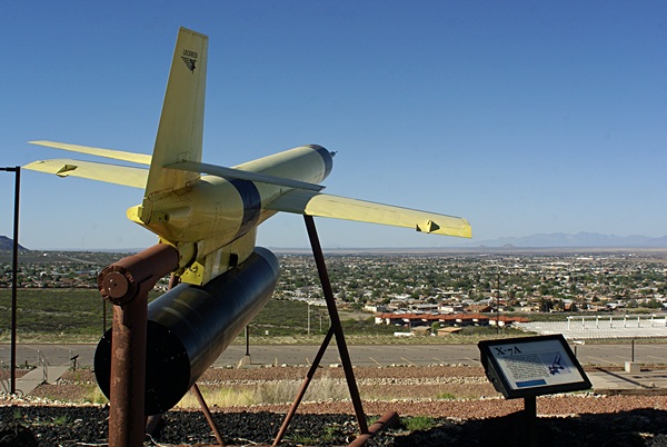
The museum sits on high ground at the base of much higher mountains and offered a commanding view of Alamogordo and the Tularosa Basin. The white sands of White Sands National Monument were clearly visible, including airborne gypsum sand blown into the air by the strong southwesterly winds. We examined the outside static displays which included remnants of a WWII German V-2 that was test-fired at the White Sands Proving Grounds after WWII, went off course, and crashed just southeast of the location of the present day museum. Alamogordo was much less developed then than it is now, but it was still very lucky that it did not land in a populated area.
Admission to the museum was $6 per person (senior rate) which was a fair price. We took the elevator to the 4th floor and then worked our way down using the ramps that connect the floors. As you might expect, the museum places special emphasis on the role of New Mexico in the development of missile technology and space flight, in particular Holloman Air Force Base and White Sands Missile Test Range (formerly White Sands Proving Grounds). The museum had an excellent collection of space and missile related artifacts with excellent explanatory signage. As with most good museums it would have taken a long day, or several shorter visits, to actually read everything.
A view towards Alamogordo from the outside display area at the New Mexico Space History Museum.
Even with the white gypsum sand blowing in the wind you can see great distances. It was thus odd to contemplate that the Trinity Site, which lies some 60 miles NW of the museum, might be visible from where we were standing. This is the place where the first nuclear bomb was exploded and the flash, followed by the mushroom cloud, must have been visible here in Alamogordo, and the sound surely must have been heard.
From the museum we headed north on US-54 towards Tularosa and stopped at the Eagle Ranch aka Heart of the Desert pistachio farm, processing facility, vineyard, and winery. We tasted a variety of pistachios and sampled five wines. Two of the wines appealed to us so we bought a couple of bottles of each. We also bought several bags of the green chile pistachio nut meats. We drove next door to check out McGinn’s Pistachio Farm and Winery and sampled more nuts, including some pecans. We only had a few minutes so we did not buy anything and headed back to Eagle Ranch for the 1:30 PM tour. The tour lasted 45 minutes and we gained some insight into how pistachios are pollinized, harvested, processed, and packaged. Pistachio trees are not pollinated by bees or insects but rather by the wind. Because of that pistachio plantations intersperse a mail (pollen producing) tree after every 8th female (nut bearing) tree. The location of the male trees is offset in each subsequent row so the pollen as the maximum opportunity to find its way to all of the female trees.
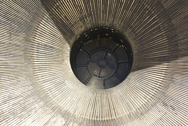
The exhaust nozzle of a Saturn V rocket engine. It is more than wide enough for a person to stand up in it.
After the tour we finished the trip into Tularosa to have lunch at the Tulie Cafe. It turned out to be closed on Tuesdays, so we headed back to Casa de Suenos. Bell had a cheeseburger and we both had taco salads with beans instead of animal protein. Bell enjoyed her cheeseburger and the salads were good. The red and green salsas that came with the warm tortilla chips were excellent.
On the drive back we stopped at the Alamogordo Chamber of Commerce where there is a display recognizing all of the military personnel from the Alamogordo area who served in Desert Storm. Each person has a brick with their name and rank at the time of their service. Bell showed us her brick and I photographed it and took a picture of her pointing to it. We then spent a little time in the small museum before driving Bell back to her house. Considering that she did not know us very well when we arrived on Wednesday she was a gracious tour guide and enthusiastic ambassador for her home town.
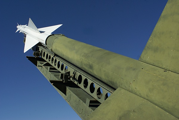
An Army tactical missile and launcher at the New Mexico Space History Museum.
Back at our coach Linda called the Route 66 RV Park in Edgewood, New Mexico to verify that they were open and had spaces available. The answers were ‘yes’ and ‘yes’ so that is where we are headed tomorrow. Linda checked the weather forecast and there is a high wind warning out starting tomorrow afternoon and running into the overnight hours. In light of that information we decided we would leave first thing in the morning and try to get to our destination before the winds really kicked up. With that in mind we went ahead and hooked up the car. I then dumped the holding tanks and cleaned the bus windshields while Linda did a small load of laundry.
Although not fancy, Desert Paradise RV Park was an excellent place to stay and we would certainly stay here again. It is right off the main highway, but tucked behind some commercial buildings and very quiet. It is convenient to Alamogordo, Holloman AFB, White Sands National Monument, the White Sands Missile Test Range, and destinations in the mountains to the east that we did not visit. The RV sites are large with easy access, the clubhouse facilities are very nice, and the Wi-Fi was the fastest and most solid we have experienced all winter.
2015/04/08 (W) Moving North and West
Today was a travel day for us which meant we skipped breakfast and coffee. We only had a little over 220 miles to travel and would normally have targeted a 9 AM departure time. The weather forecast, however, was for very strong and gusty winds with a high wind warning starting at noon for the area where we would be traveling. The jet stream was responsible for the wind, having dipped far south over North America and dropped in altitude. We got up a little after 7 AM and pulled out of our site at the Desert Paradise RV Park at 8:14 AM.
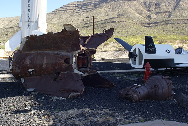
The remains of a WWII German V2 rocket that was test-fired at White Sands Proving Grounds just after the war ended.
We took the US-54/US-70 Relief Route that bypasses most of Alamogordo just west of the city. The drive up US-54 through Carrizozo and on to Vaughn was scenic and uneventful, even with the occasional construction zone. We were traveling north to northeast so the winds out of the southwest were mostly on our tail and helped push us along. It also made for a much quieter ride than usual by reducing the net wind speed at our windshields.
Around 11 AM we picked up US-60/NM-285 in Vaughn and turned west. That is when we got the full brunt of the wind which seemed to be out of the west. Linda checked the weather for the area and it was showing sustained winds of 34 MPH out of WSW with gust higher. Driving the bus at 60 MPH into a 30+ MPH headwind is the same, in terms of wind resistance, as driving it 90 MPH through still air. The bus only has so much horsepower and was not able to sustain 70 MPH into this wind, not that I wanted to go that fast anyway. I found that both the bus and I did better if I left the transmission in 4th gear and set the cruise control at 55 MPH. Even with that configuration it was producing more power and higher exhaust gas temperatures than it would have without the headwind.
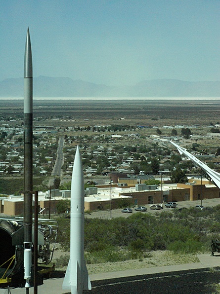
The view to the west from the 4th floor of the New Mexico Space History Museum. The “white sands” are visible on the horizon and blowing into the air.
NM-285 split from US-60 in Encino and headed northwest while US-60 headed southwest. Our northwesterly track meant we had a strong crosswind component and some headwind. We continued to climb and the terrain became more steeply rolling hills. I was able to travel 63 MPH through this stretch of the trip, which was fast enough, and maintain at least 55 MPH on the steeper hills by getting on the accelerator coming down to low points, staying on it up the other side, and dropping the transmission into 4th gear as the speed and RPMs started to drop.
When we reached Clines Corners and entered I-40 westbound we once again had the wind mostly in our face and I decided to run at 55 MPH in 4th gear. These were the strongest winds of the drive and had also become very gusty which, combined with Interstate highway traffic, made this the most challenging and stressful park of the trip.
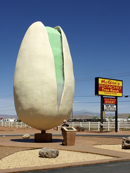
Linda poses with the world’s largest pistachio. Note the wind-blown hair.
Most of the drive was also a gradual but steady climb which meant the engine was again usually producing more power than it does on level terrain. We were at an elevation of 4,341 feet ASL in Alamogordo but by the middle of the drive had topped out at over 7,200 feet ASL and never dropped below 6,000 feet ASL the rest of the trip. That, combined with the wind resistance, meant the engine ran a bit hotter than normal for most of the drive. Although the engine coolant temperature never rose above 195 degrees F the pyrometers indicated closer to 700 degrees F, climbing to 850 to 900 degrees F on steeper/longer grades and dropping to 300 degrees F (or less) on down slopes. The pyrometers normally run 500 to 550 degrees on level terrain. The turbo boost also ran a few PSI higher than it normally does on level terrain and often climbed above 12 (on the new gauge) and several times peaked at 15 on the steepest grades. I rarely see turbo boost readings on the new gauge above 15 and the maximum I have ever seen is 16-17.
Google Earth Pro indicated that we would encounter up and down grades on this route near 6.0% but an average of only 0.9% upgrade overall. There were many hills on NM-285 that were 4% and several that were probably 6%, but they were short climbs and the bus handled them well. Indeed, the coach ran very well all day including how it handled the wind. It was a lot of work for me, but it was doable.
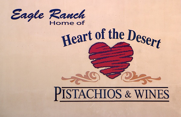
We went on a free tour and bought wine and green chili seasoned pistachios at the Eagle Ranch
We took exit 187 off of I-40, looped back to the east on Old Route 66, and a mile later pulled into the Route 66 RV Park in Edgewood, New Mexico. As we entered the RV Park there was a sign with a phone number to call so Linda called it. The owners were away from the park but gave us directions on the phone to get into site # 12. The park is built on a north-facing slope with a sweeping view in that direction and all of the sites are cut from the hillside. Site #12 had full hookups with 50 A electric and easy pull through access. It was also very wide so we did not have to squeeze the bus in and could park our car next to the bus instead of behind it. The site was not perfectly level but it was close enough that we were able to level the coach using the built-in air-suspension leveling system.
The owners returned while I was hooking up the shorepower and Linda was arranging the interior. She got us registered and then we unhooked the car. With our arrival chores completed Linda sautéed onions, red bell peppers, and kale and heated up two Tofurkey brand vegan Italian sausages.
Route 66 RV Park has two Wi-Fi signals so I used the Wi-Fi Analyzer app on my smartphone to see how the 2.4 GHz band looked. As usual there were lots of signals trying to use Channel 6 (in the center of the band), and a few signals at lower Channels, but the park’s second access point was on Channel 11 all by itself, so I connected our WiFiRanger Mobile-Ti to the second access point. We then got our computers out, powered them up, and got them connected to the Internet.
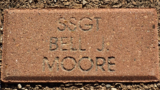
A close up view of Bell’s Gulf War commemorative brick.
The wind continued to blow and the gusts increased in strength. We were both tired and had slight headaches, perhaps from the higher altitude, the stress of driving in the wind, the lack of our morning coffee, or some combination of the three. Whatever the cause we both drank some water and then took naps. When we finally got up Linda sautéed some fresh green beans and reheated the last of the seitan mock stroganoff and served them with quartered apples.
After dinner we experimented with different directions for our TV antennas and found one that captured a lot of stations, including the local PBS affiliate. Given the winds we appreciated the advantage of having OTA TV antennas that are contained in low profile, aerodynamic housings. We would not have been able to deploy a conventional crank-up antenna under these conditions.
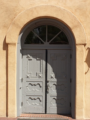
The door of the early 18th century mission church in Old Town Albuquerque, NM.
I checked the fresh water tank gauge as Linda was doing the dishes and it was below the 1/3rd level. I got the water softener and separate pre-filter out of the front bay and hooked everything together. Once I turned on the water I could see that the level in the tank was ~1/4. It took about 35 minutes to fill the tank and the water softener was depleted by the time it was full. That means I will have to regenerate the softener, a task I have come to dislike with our present equipment. Once the tank was full I disconnected everything and returned the equipment to the front bay. The low temperature for this evening is forecast to be 36 degrees F so I did not want to leave the water filters, softener, and hoses outside with water in them.
Linda read and watched TV while I processed photos from our drive to/from Bouse, AZ back on March 2nd. We drove through a very strong storm on that drive and captured a few interesting pictures. I looked at my draft blog posts for early March and decided to consolidate the posts for March 1 – 3. I got the compilation done but was too tired to upload it to WordPress, integrate the photos, and generate all of the tags, so I went to bed. The wind continued to blow and gust strongly but I eventually fell asleep to the gentle (sic?) rocking of the coach.
2015/04/09 (R) Albuquerque, New Mexico
The forecast low for last night here in Edgewood, New Mexico was 36 degrees F. The actual low turned out to be 28 degrees F, so I was glad that I disconnected the fresh water equipment last night and stowed it back in the front bay. Linda was up before me this morning and when I got up the temperature in the coach had only dropped to 66 degrees. We were very comfortable in our sweat pants/shirts but I turned on the electric heaters briefly to warm it up a few degrees. We have not used space heating in quite some time.
One of the many little seculded plazas in Old Town Albuquerque, NM.
I made a pot of coffee and it occurred to me that our mild headaches yesterday may also have been influenced by the lack of our usual morning brew. Not that we consume a lot of caffeine in the morning. I usually make 6 – 8 cups of coffee and it is always half decaffeinated beans, so we each get 1.5 – 2 cups of caffeinated coffee. Not a lot, really, but probably enough that our bodies don’t like it if we skip a day. Linda made oatmeal for breakfast, after which I uploaded my blog posts for March 1, 2, and 3 (2015).
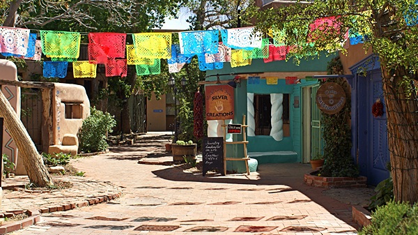
Linda spent a little time looking at recommendations on RVillage for what to see and do in and around Albuquerque and Santa Fe and did some additional research online. We decided to head for “Old Town” Albuquerque by way of Historic Route 66. That turned out to be especially easy as our RV Park is on Old Route 66 which is Central Avenue in Albuquerque and runs right across the southern edge of Old Town.
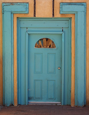
One of the many very old doors in Old Town Albuquerque, NM. I think doors make interesting subjects for photographs.
We left Edgewood around 9:45 AM and drove the 20 miles to Albuquerque on Route 66 which is closely paralleled by I-40. Route 66 has lower speed limits than I-40, and once we hit Albuquerque we had a lot of stoplights, so it took about an hour to get to Old Town but we got a good look at that part of Albuquerque. Most of the available parking around Old Town is in pay lots and, not knowing anything about the area and what else might be available, we went into one of the first ones we came to. We also did not know how extensive the area was or how long it would take to see it so we paid for all day parking.
Our first stop was a plaza with public restrooms. The visitor information center was in the same plaza and a very nice lady helped us with maps, brochures, and advice based on personal experiences. Old Town dates from the early 1700’s. It features a lot of low, (faux) adobe style buildings, but very are historically old. Most of the shops sold art and jewelry but there were a few were T-shirt shops and places to eat.
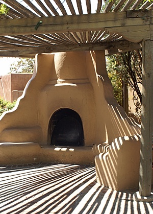
An interesting fireplace under a Ramada in Old Town Albuquerque, NM
We went in one t-shirt shop and saw several things that we really liked. Just down the street we struck up a conversation with a Native American gentleman, David Ramirez, who had some wonderful paintings that were part of a large scale, long-term project he is working on. He was from the Chippewa Tribe in Mt. Pleasant, Michigan and attended the University of Michigan in Ann Arbor years ago to study art. We were very tempted to buy something but we were just at the beginning of our stroll through Old Town and did not want to carry merchandise, so we got his business card with his contact information and decided to ponder whether we wanted to make such a purchase.
From Old Town we continued west on Central Avenue looking for Coors Blvd. NW and then Atrisco Dr. NW and Western Ave. NW which finally brought us to Unser Blvd. NW and the entrance to the Petroglyphs National Monument Visitor Center. After checking in and stamping our NPS Passport we had to drive another two miles north on Unser Blvd. NW to an area of the Monument where there is a short loop road to stops at two parking lots and provides access to three hikes. One of the hikes involved a rough path that climbed a couple of hundred feet up a steep hill, but it was worth the effort. We took our time and saw lots of petroglyphs as well as sweeping views of the Albuquerque metropolitan area far below us to the east. Indeed, one of the trail markers informed us that we were exactly 5,280 feet above mean sea level.
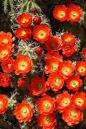
A cactus in bloom along the trail at Petroglyph National Monument, NM.
From the Monument we worked our way east over the Rio Grande (river), north on 2nd Street to NM-556 (Roy Ave. NE) which crossed I-25 and became Tramway Road NE. Tramway took us east along the north edge of Albuquerque towards the Sandia Mountains and then turned south to run along their western base. Tramway eventually intersected I-40 which we got on going east for the 20 mile drive back to the Route 66 RV Park in Edgewood. Tramway is so named because of the cable car that operates from a base at the northeast corner and takes passengers up to the top of the Sandia Mountains. The tram was closed for service but we would not have gone anyway regardless of the price. Linda does not do Ferris wheels, ski lifts, and cable cars.
When we got back to our coach Linda reconstituted one of the dried Hatch chiles we bought at Hatch Chile Sales in Hatch, New Mexico and used it to season a southwestern style beans and rice dish. After dinner I worked with the consolidated draft blog posts for the days of the Escapade RV rally but did not have the time to select a few photos from the 3,000+ that I took during the event. We planned to leave early tomorrow for Santa Fe and Bandolier National Monument and I needed to get to bed.