SATURDAY 17 September
(There are 17 photos in this post, distributed throughout the text. All photos taken with a Google Pixel 6 Pro smartphone.)
I got up around 0615 this morning. The zone 2 heat-pump blower had just shut off but the compressor sounded like it was still running. It should have shut off before the fan. I needed to get up anyway, but, the change in sound/behavior of the unit got my attention right away, at which point I was wide awake. The overnight low was forecast to be ~40 (F), but when I checked my phone it indicated 38 (F) in Shelburne, New Hampshire. I had set the thermostat to 63 (F) before going to bed, so the heat-pump was trying to maintain a 27-degree difference with the ambient temperature outside. It had cycled on/off all night without any apparent problem.
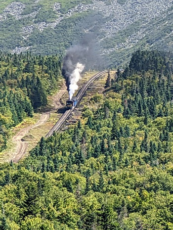
Our first view of the Mt. Washington (NH) Cog Railway. As we arrived at the base station, the steam train was already chugging its way up the mountain.
I was not sure what the lower temperature limit was for the heat-pump (in heating mode) so, out of an abundance of caution, I turned off zone 2. I then went about the business of clearing the kitchen counter of last night’s dishes so I could fill and start the kettle. Linda was awake by then, so I put zone 2 on furnace mode and proceeded to make our morning coffee. (The furnace is loud.) By the time she got up, both of our phones indicated the ambient temperature was 36 (F). We have been in below freezing temperatures with our trailer before—so we knew the trailer could handle it as long as we had propane and did not let the water hoses freeze—but it’s not something we choose to do on purpose. I saw 35 (F) briefly, but the temperature started rising once the sun was up.
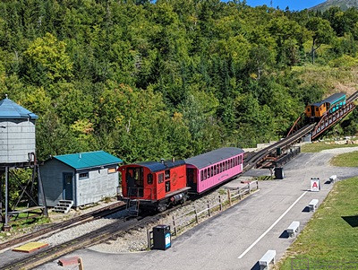
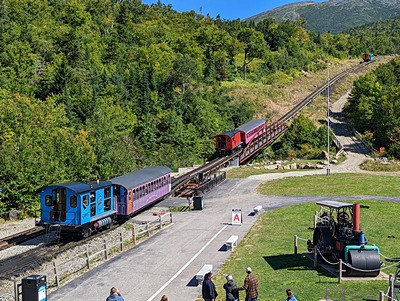
Three bio-diesel trains were loaded and run at the same time. The first train in line was ‘A’, the second was ‘B’, and the third was ‘C’. The passenger waiting areas on the loading platform were marked accordingly. The ‘A’ train is going over the bridge and the ‘B’ train is waiting its turn.
By 7:30 AM our phones were indicating 41 (F) with a forecasted high of 69 (F). The forecasted high temperature for the summit of Mt. Washington, however, was 46 (F) under sunny skies, with moderate winds under 20 mph. And that mattered, because that was where we were headed today to ride the cog railway to the summit. Assuming this all went to plan, it would be our second visit to Mt. Washington. The first time, many years ago, I drove our Taurus station wagon to the top. Linda made it clear that she would never do that again, then and now. We were not going to hike up (to 6,288 feet), thus the cog railway. Besides, it the rail line has an average grade of 25%, with sections as steep as 37.4%, and we wanted to ride it just for the experience.
Linda was checking the route to get there, and discovered that Hwy-16 out of Gorham was NOT the way to go. Both her iPad and phone indicated that we had to go west out of Gorham and around to the west side of the mountain. She checked the website, and it clearly stated the many GPS mapping apps do not know how to find the train station, which “is in a remote mountainous area.” The key was to select Fabyan Station (Restaurant) in Carroll, New Hampshire, as the destination.
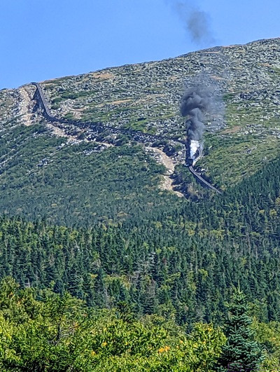
Towards the top of the mountain, the cog railway tracks run next to the Appalachian Trail and close to the edge of the deep , closed end of a cirque. He tracks in this section run on a wooden trestle know as Jacobs Ladder.
I thought I recalled, from our first visit year’s ago, driving north on some road and turning left to get in. We saw a sign on US-2 going into Gorham that said to go left/south of ME-16 for the “Mt. Washington Auto Road.” We eventually figured out (read somewhere) that the auto road and the cog railway are on opposite sides of the mountain. Mystery solved; memory still pretty much intact.
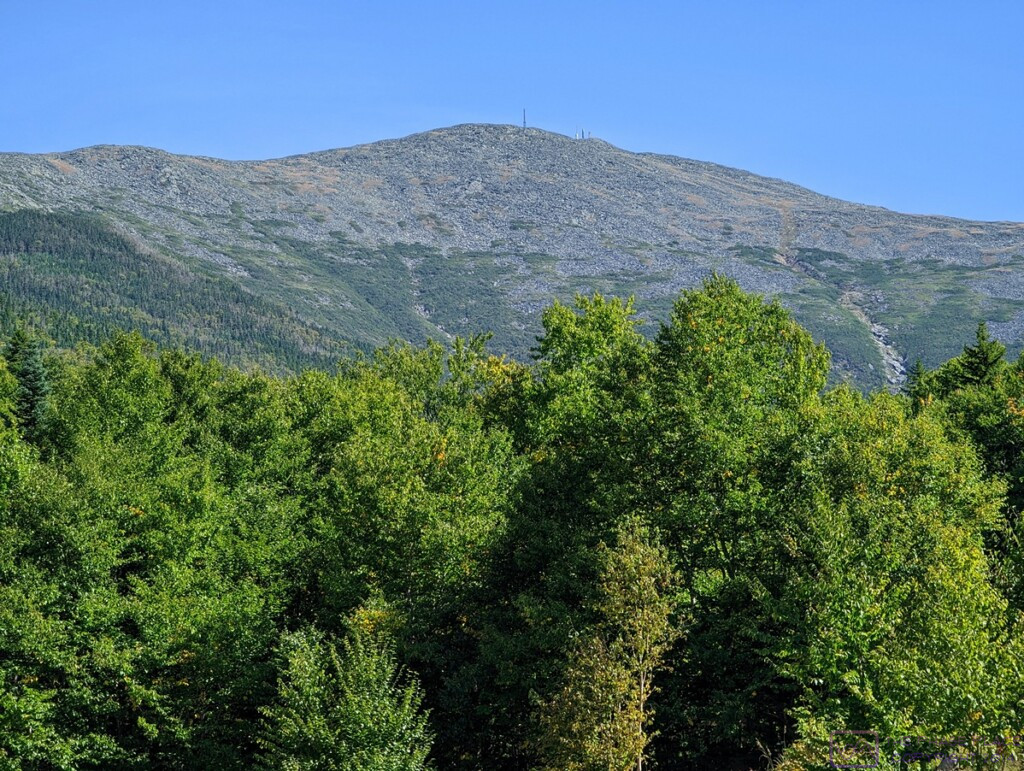
From its base at Marshfield Station, elevation 2,700 feet AMSL, the cog railway passes through four distinct climate zones on its way to the summit, at 6,288 feet AMSL. Our conductor provided excellent narration on the trip up, and pointed out each zone as we entered it. The changes between zones were fairly distinct. (This photo is 1198×902 pixels; click to enlarge.)
Yesterday, Linda made reservations for the 1 PM bio-diesel train. (The steam train was already fully booked.) The website said they board 15 minutes before departure, but suggested we check-in an hour ahead of time. We left at 10:45 AM for the 50-minute drive. We were there and parked in plenty of time. The steam train had left just before we arrived, and we watched it chug its way slowly up the mountain, belching great quantities of black smoke and white steam condensation, before going into the Station.
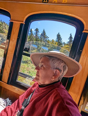
This is not a trick photo; the camera was level. Notice that the trees behind Linda and vertical. The average grade on the Mt. Washington Cog Railway is 25%, but the steepest portions are 37.41%. The locomotives and the seating (benches) in the passenger cars are designed with this in mind, so the ride up, and down, is comfortable. Passengers were free to stand up and move around except when going through switches. Several people on our train did that just for fun.
In the station, we got our boarding passes and then went back outside to the loading platforms and watched the three noon trains, all bio-diesel, load their passengers and pull out. The trains were lined up, nose-to-tail, and there was a designated loading area for each one. These areas were referred to as Platform A, B, and C, and each passenger car had a corresponding sign on it. (I noticed later than the signs were part of a flip-board system, so any given car could be designated A, B, or C as needed.)
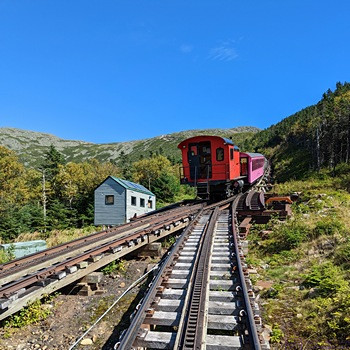
A second rail line was eventually installed from the base station to the mid-point (approximately). The switch at this point allows trains to leave the base station and the summit station at the same time. We were on the upbound ‘A’ train. There was a delay in the downbound train(s), and we had to wait about 15 minutes at this switch for them to pass. The ‘B’ and ‘C’ trains were waiting behind us.
Back inside, we passed the time in the gift shop and museum. There was also a café, but we were not in need of food. The museum was small, but big enough to tell the story of how the cog railway came into existence. Construction started in 1866, and it was opened to the public in 1869. It was the first cog railway ever built. The first one in Europe was opened in Switzerland in 1871.
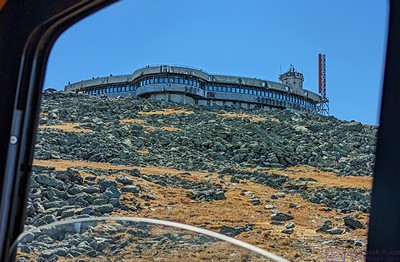
The Sherman Adams building at Mt. Washington State Park. It includes a visitor information desk, restrooms, cafeteria, gift shop, museum, “pack room,” access to the main meteorological station, and a U.S. Post Office branch. (Linda had some post cards with her, and mailed them from here.) The State Park encompasses ~ 60 acres of the summit.
As the 3/4-hour mark approached, we moseyed out to Platform A. Many of the passengers for our car were already there, but no worries about being at the front of a line; all seats were reserved. We had seats A/11 and B/11 for the round-trip. The passenger cars were all set up with two seats on one side of the aisle and three on the other, much like a smaller airliner. When boarding a conveyance, one would normally look for their row (11) and then their seat (A or B). For whatever reason, the railroad company printed their boarding passes with the seat and then the row, and this seemed to confuse a lot people (rightfully so). People also seemed to be confused about the fact that if “A” is by the window on one side (it was) then “E” would be by the window on the other side.
One of the things we wondered about was how the seats would work, given the steepness of the grade and the fact that the passenger cars could not be turned around at either end of the track. The answer was reversing (flip-over) seat backs. Brilliant! Each time a load of passengers disembarked, the engineer went through the car and flipped all of the seat backs. Thus, the passengers were always facing in the direction the train was moving.
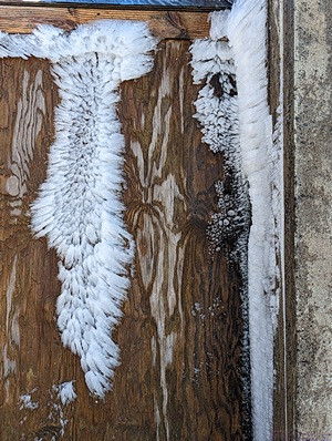
Just a couple of days before our visit, Mt. Washington had 60+ MPH winds with hurricane force gusts above 90 MPH. Temperatures dropped into the 20s (F) and caused a sudden freezing of the moisture in the air. Remnants of that event were still very much in evidence, even though it was clear and sunny, with the temperature in the upper 40s (F). This ice was on a wooden door to a small building.
The bio-diesel trains left Marshfield Station (usually three at a time) on the hour from 9 AM to 3 PM. (The steam train was slower and left at 8:30 AM and 3 PM.), and operated in such a way that passengers got exactly 1-hour at the summit. We had seats A/11 and B/11, on the 2-seats side of the passenger car, for the 1 PM, Platform A train. The ride up took about 45 minutes (approximately 3 miles at 4 mph), plus a 15-minute delay at the switch for downbound trains to get on the second/parallel track to Marshfield Station. As soon as we disembarked, at 2 PM, the conductor called “all aboard for the noon train.” These passengers had left Marshfield Station at noon and arrived at the State Park at 1 PM. Their 1-hour visit was up, and it was time to go back down; same boarding pass for the same Platform and seats, but a physically different passenger car. One hour after our train arrived, a conductor called “all aboard for the 1 PM train.” All of the seats were reserved, so no need to stand in line or jostle for position.
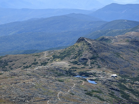
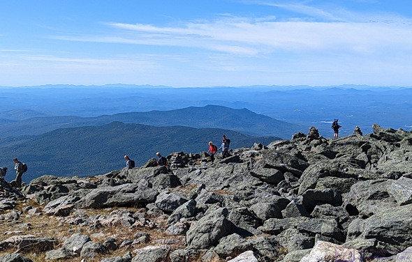
Southwest from the top of Mt. Washington is the Lakes of the Clouds Hut and trails. About a half dozen trails converge here (depending on how you count), including the Appalachian National Scenic Trail. Hikers can spend the night here and get food and some other supplies. The supplies are airlifted in by helicopter several times a year.
The ride up was wonderful. The cog railway itself is an engineering marvel. Started in 1866, it opened to the public in 1869. It was the first cog railway in the world, and has been in operation ever since. It’s been updated over time, of course֫—most of the trains now use the bio-diesel engines, and the passenger cars are enclosed with operable windows and heaters—but it is genuinely historic, and the operation retains much of that flavor. And the views … “on a clear day you can see forever.” Maybe not forever, but we had a very clear day, which was unusual in and of itself, and we could see a long way, up, down, and out.
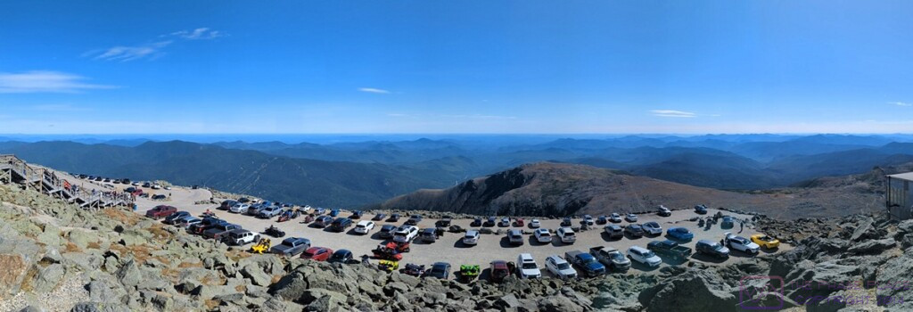
If you drive up the Mt. Washington Auto Road (which we did years ago), this is where you park. The view is looking approximately southeast.
On our visit many years ago, we were told that on a really, really clear day, you can see the Atlantic Ocean. We didn’t then, and we didn’t today. A sign today said that on a clear day, you can see 60 miles in every direction. There was distant haze today, ad my guess was that that we could probably see about 50 miles, at least in some directions. I remembered from our last visit that those kind of viewing conditions exist less than 30 days each year, so twice lucky.
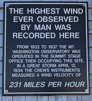
The highest (sustained) winds ever recorded on earth, 231 MPH, occurred here on 12 April 1934. Mt. Washington is the highest mountain peak in the U.S. east of the Mississippi River and dominates the Presidential Range in the White Mountains of New Hampshire. The extreme weather here is not just due to its elevation. The mountain in the path of three major, and three minor, storm tracks. Visibility at the summit is only good about 30 days out of the year, but we have been lucky enough to be here twice with excellent visibility and relatively pleasant weather. The highest temperature ever recorded at the summit was 72 (F).
An interesting fact about this whole operation was that 60 acres at the top of the mountain was the Mt. Washington State Park. Two interesting sub-facts were that this property was acquired from Dartmouth College, and there was no State Park entrance fee. (My guess was that it was included in the price of , our tickets.) Another interesting fact was that a large number of trails lead up to and around the summit, one of which was the Appalachian National Scenic Trail. Besides train and car visitors, there were a lot of hikers on top of the mountain, and we saw many more on the various trails below. The facilities in the Sherman Adams Building were very much in use by the hikers, whether mailing a post card or letter, or getting something to eat. There was even a “pack room” where they could leave their packs while they were there. They could not, however, stay overnight. The only people who get to stay on the mountain overnight are the meteorologists that work there.
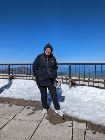
Linda pauses on the observation platform (roof) of the Sherman Adams Building at Mt. Washington State Park. The white stuff is the remnants of the flash ice event that occurred a couple of days earlier. The view is looking approximately northeast.
While we were “up top” the air temperature was ~47 (F) and the wind was very modest at under 20 mph. But the recent flash ice event was still very much in evidence, and 20 mph at 47 (F) has a bit to it. We had anticipated this, and dressed in layers. Indeed, Mt Washington is known for its extreme, and changeable weather. Hikers need to know what they are doing, have the right gear, check the weather forecasts, and pay attention to them. Above the 4,000-foot level, cover starts to get thin, and above the 5,000-foot level it is non-existent. The trails at this level amount to picking your way through rocks between cairns, which are placed about every 30 to 40 feet. Visibility can get so low, that hikers cannot see much beyond the next cairn, and there are places where the trail is near the edge of 2,000-foot cliffs.
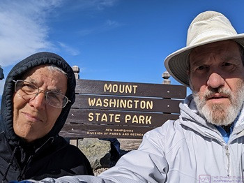
There were things we did not do at the summit. There is an actual summit rock with a sign, and there was a long line of people waiting to take a picture there. Our conductor had suggested we not waste our hour waiting to do that, which was god advice. We did not get anything to eat, and we did not visit the museum. Linda did, however, make use of the U. S. Post Office. She had a couple of post cards with her, and stamps, so she used a pen at the State Park Visitor Information Desk to fill them out, and dropped them in the USPS mailbox.
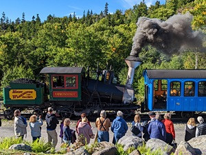
Back at the Marshfield Station, one of the steam trains was preparing to board its passengers and head up the mountain.
Although the Mt. Washington Cog Railway seemed a bit pricey at first ($87 for each ticket), by the time we got back to Marshfield Station it felt like it was worth the price. It’s a large, complicated, and no doubt expensive operation. It was also unique and it is a private enterprise that needs to make a profit.
On the drive back we started to take the Old Cherry Mountain Road, but changed our minds. As soon as we turned onto it, we could see that it was gravel and narrow. Our F-150 XLT 4×4/FX4 could have handled it easily, but we were not up for more adventure at that moment. We returned to our campground via the reverse of the route we took to the Mt. Washington Cog Railway Marshfield Station through the stunning Presidential Range.
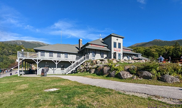
The Marshfield Station building as we were headed back to our truck. The summit of Mt. Washington is behind the chimney.
Back at camp we settled in and I started working on photos from our train trip. For dinner, Linda grilled hot dogs and corn-on-the-cob, with fresh fruit on the side a some more of the Menage a Trois Midnight wine. After dinner, Linda scanned for TV channels but didn’t come up with anything. We had a good enough Verizon signal that she was able to stream the first episode of the new season of The Great British Baking Show. It was thoroughly delightful, as always, and a nice change of pace.
…
