MONDAY 01 August
As July turns to August, we are nearing the end of the 7th week of our Atlantic Canada trip. And, with our arrival on the island of Newfoundland, Province of Newfoundland & Labrador, it was officially an “Atlantic Canada” trip and not just a “Eastern Canada” or “Maritime Provinces” trip. We’ve been camped in the heart of the Gros Morne National Park (Parks Canada) since our arrival, and it’s been wonderful; the place, the people, and the weather. But, like all National Parks, it exists for a variety of special reasons. And one of the most special was the Tablelands area in the south of the park. But more on that in a bit.
Because I was unable to create blog posts late last night, I got up at 6 AM this morning and got right to work (after my usual morning routine). The KOA Wi-Fi connection was solid, the signal strength was good, and the data transfer was fast enough to be able to work efficiently. I had managed to publish one post last night on “Leaving Nova Scotia(for now)”. This morning I was able to publish two more—one on our experience with the Marine Atlantic Ferry, and the other on our arrival in Newfoundland—all before having breakfast getting ready to leave camp for the day. Linda slept in a bit, but was ready to leave before I was, as is almost always the case.
There is a passenger ferry that sails between Rocky Harbor to Woody point in about 15 minutes, but it’s people only, no vehicles. The drive between these two towns took us about 80 minutes, give or take.
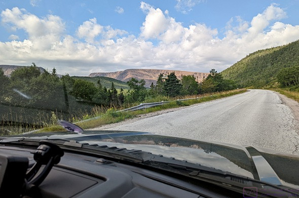
The light / barren mountain ahead is the Tablelands area of Gros Morne NP (photo by Linda).
The Tablelands is a flat-topped mountain area in the south portion of Gros Morne National Park. And it was here that a geologist started to piece together the evidence that eventually turned plate tectonics (continental drift) from a hotly contested scientific hypothesis into a solid and accepted scientific theory. It is considered one of the most important scientific advances of the 20th century and led to a UNESCO World Heritage Site designation. That designation led, in turn, to the creation of Gros Morne National Park.
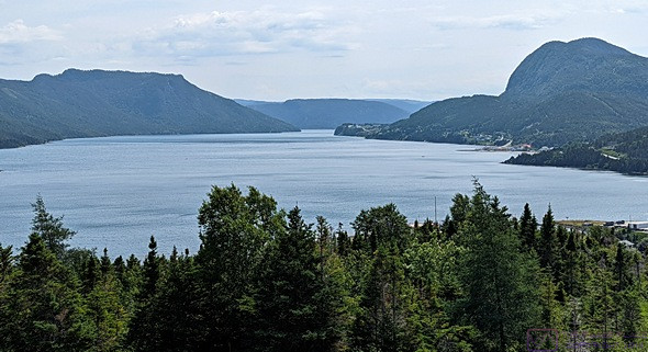
The southern tip of the South Arm of Bonne Bay from the Tablelands Visitor Center. (The Tablelands is to the right , out of the frame).
So, what was the evidence? The Tablelands, and a few other areas in the park, is one of the few places on earth where the earth’s mantle was pushed above the earth’s crust in the collision between continental plates, AND it is accessible enough that people can walk on it. We had read about this prior to coming to Newfoundland, and it was our top “must do” item in the park.
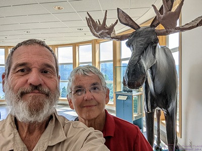
We finally saw a Moose! This one is paper mache, at the GMNP Visitor Center.
The Woody Point Visitor Center was very nice, with an information desk, café, gift shop, and display area detailing the geology of the park and its significance. There was also an area devoted to a major project to collect detailed local knowledge from the inhabitants of the area about the geology, hydrology, flora, and fauna, including the plants and animals of the lakes and ocean. Another area was set aside for exhibits which change over time. The current one featured photographs of Labrador created by seven photographers from Labrador.
Julie, our Tablelands Trail interpretive guide.
It would be pointless for me to say any more about the specifics of the geology but those details were important to us, which is why we wanted to go on the guided trail hike. Our guide was Julie, and she was very good.
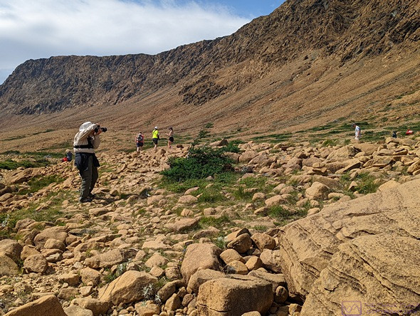
Bruce doing his photography thing along the Tablelands Trail, GMNP (photo by Linda).
Julie had obviously learned and internalized what she needed to know to lead this interpretive hike. She spoke with clarity and enthusiasm from knowledge rather than a script. Equally interesting to us, and unexpected before getting there, was that about half of what she talked about and showed us along the trail was biology rather than geology, and the important connection between them in this place. We also learned that nearby Woody Point is the snowiest place in all of Canada. Not in Newfoundland; in the entire country.
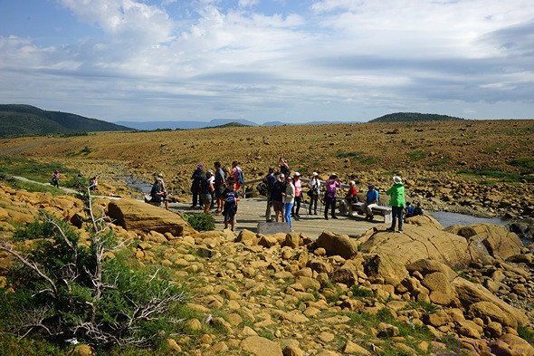
Our guided hike group was large, probably 40 people, but Julie did a great job. This is the platform at the end of the “developed” trail, but off-hiking is permitted here as long as you are careful not to disturb the flora. (Linda is third from the right in the red shirt, sitting on the bench.)
The guided hike took about 90 minutes to reach the end of the defined trail and Julie stuck around for a while to answer questions. Many of the hikers were as curious to know more about her as they were about the Tablelands. A graduate student in political economics with an interest in the environment and ecology, this was her 4th summer working for Parks Canada. She had previously been at Banff National Park but applied for the assignment as an “Interpreter” in Gros Morne NP.
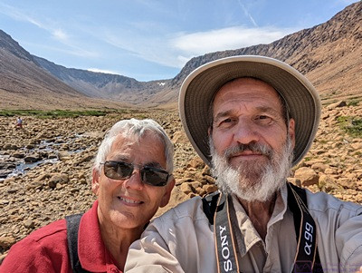
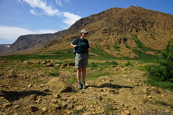
Selfie at the end of the Tablelands Trail which provides of view of the cirque behind us.
The Tablelands is on the south side of an east-west, “U” shaped valley that was gorged out by glaciers. It is strikingly barren and other-worldly, in sharp contrast to most of the National Park. Indeed, the other side of the valley is a balsam fir boreal forest.
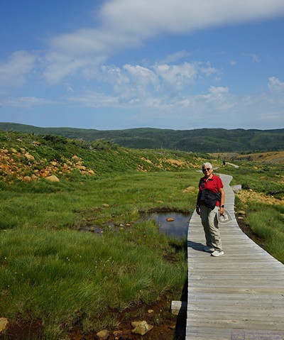
Linda on the Tablelands Trail boardwalk near the end. The green ridge behind her is balsam fir boreal forest. The geology there is very different from the Tablelands mantle rock.
We lingered at the end of the trail and had a long chat with several other hikers. One couple was staying at the same KOA as us, and owned the third Airstream travel trailer we noticed the other night. And the husband was an amateur radio operator (ham). And their home base was just west of St. Louis, Missouri. We grew up in a northern suburb of St. Louis. We then had a slow walk back to the trailhead parking lot, taking photos along the way.
We returned to the Visitor Center to check out the offerings at the café, but there wasn’t anything for us. We returned to our truck and had trail mix bars and water. Before returning on Hwy-431 to Hwy-430 we drove through Woody Point. It was an interesting mix of an authentic “Newfy” fishing village with a purposefully quaint waterfront designed to please tourists and locals alike. We thought about stopping, but parking was higgledy-piggledy, and the eating establishments all appeared to be busy.
Linda had studied the park map and located all of the “easy” hikes. One of them was the South East Brook Falls Trail, and she spotted the sign for the parking lot on the drive down to Tablelands. It was a short (less than 1/2 mile) return trail that led to a waterfall with a 40 m (~ 132 ft.) drop. I missed the turn, but found a place not to far along and turned around. And I was glad I did.
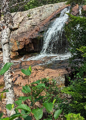
Near the top of South East Brook Falls from the South East Brook Falls Trail.
Trails are considered “easy” in this part of the world if they have an elevation change of less than 100 m (~ 330 ft.). What I don’t know is how that is measured. Is it the difference in elevation between the highest and lowest point on the trail, or is the total amount of “up grade” elevation gain, i.e., trail that begins at sea level and then goes up to 10 m and back down to sea level 10 times. Not that it matters. What matters is the easy does not mean, flat/level, or that the surface/footing is easy to walk on our navigate. The Tablelands Trail was designated easy, but had quite a bit of elevation gain, almost entire up from the parking lot to the end point. Most of the trail was gravel, which was brought in and supported flora that the actual Tablelands rock did not. But we often went off-trail, and where the footing was loose rock, and a bit trickier.
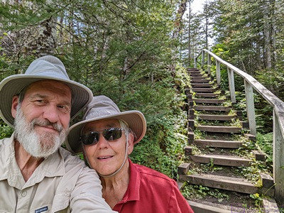
A selfie at the mid-trail stairs. Trail improvements like this allow a trail to be designated “easy.” We really enjoyed our walk on this short trail.
The South East Brook Falls Trail left the parking lot and immediately went downhill. Literally, it went down the side of hill and into a forest. And it continued to drop all the way to the waterfall. There was a staircase mid-trail and another one at the end that led up to the top of the falls. Stairs are also a feature of “easy” trails, apparently. Presumably on a moderate trail we would have had to just scramble down these slopes and on a “hard” or “difficult” trail we would have to climb over boulders and fjord streams. I supposed “advanced” or “expert” would mean technical climbing.
We didn’t bother with the top view as we could already see the water spilling over an ancient/hard granite ledge (~ 1.1 billion years old, IIRC). Most of the waterfall was below our level. We could not see it from our vantage point, and there wasn’t any way to get to the bottom and look up. Not that we would have anyway; 132 ft. is a lot of elevation change.
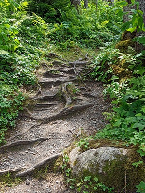
These tree roots along the South East Brook Trail had a fairy tale quality,. so of course I had to take a picture.
If that sounds like we didn’t enjoy this trail, that was not the case. It was a lovely dirt trail through a short, but nice stretch of forest. There was light getting through the trees, but we were sheltered from the heat of the direct sunlight we had on the Tablelands Trail. There were ferns everywhere, and lots of other plant life. There were trip hazards in the form of rocks and roots, but the roots provided their own interest and beauty.
We enjoyed the drive to Tablelands and back. Hwy-430 (The Viking Trail) through the park is an amazing stretch of highway engineering and construction that has gotten us into and through an even more amazing natural landscape.
It had been an interesting, informative, and active day and we finally felt the tiredness once we were back at camp. Tired or not, we had things to do. I deployed the patio awning to shield the rig from the sun. We closed up the rig and turned on one of the heat-pumps in cooling mode. I then started transferring photos to my laptop computer. Meanwhile, Linda gathered up a load of laundry and took it to the RV park laundry room. She then made potato salad and put it in the refrigerator for tomorrow night.
Based on recent conversations with a couple of different people, and some additional research on the South Labrador Ferry that sails between St. Barbe, Newfoundland and Blanc-Sablon, Quebec, we were coming to the conclusion that we would NOT do this day-trip in the truck. In that case, we would not need to be at the RV park in St. Barbe for the four nights we currently had booked.
After visiting the northwest peninsula, we planned to return to the Gros Morne – Norris Point KOA on Sunday for one night before resuming our eastward travel on the Trans-Canada Highway. We checked with the office, and they were able to add Saturday night to our existing Sunday night reservation for a 3-way/30A pull-thru site. Our plan now is to stay in St. Barbe for three nights (instead of 4), which will give us a choice of Thursday or Friday to visit the L’anse aux Meadows Viking Settlement and St. Anthony’s, based on the weather. It’s a long drive from St. Barbe to St. Anthony’s and the Viking Settlement, and we won’t have to pull the trailer those extra kilometers.
Just before dinner we got a text message from our son with a few photos attached, confirming that they had begun their trip to Banff National Park and made it to their first stop in Sault Ste. Marie with happy, smiling faces.
Dinner was sandwiches and fresh strawberries, after which I folded my clean laundry and put it away. The sun had dropped below the mountain ridge to the west, so we turned off the heat-pump, opened the windows, and I stowed the patio awing. Linda went to bed early and I continued to work at my computer with the goal of catching up on blog posts and publishing them. When I tried to log into WordPress, the response times were very long. Rather than fight with slow Wi-Fi Internet, I decided to defer this the next morning. When I went to close the door to the trailer for the night, I noticed that the sky was clear and dark and the stars were bright, so I took some time to just sit in one of the patio chairs and look at them. Seeing the stars in a truly dark sky is high on my list of things I hope to experience on this trip. There was still some light pollution from the RV park, but I let my eyes adjust and could see the Milky Way.
…