I got a call this morning from our mechanic, Joe, letting me know that he was still in Sarasota working on a bus and would not be available to visit at The Villager RV Park in Wildwood. I contacted Al at Breezy Oaks and adjusted our plans for the day accordingly. A visit with Al at Breezy Oaks was our main objective for the day, but as long as we were out we wanted to stop and see a few other things.
Rather than drive down I-75, which we have already done several times, we drove to Ocala on US-27 to where it joins up with US-301/US-441 heading SSE to Belleview. From there we continued SE on US-441 through the eastern section of The Villages, finally turning west on CR-466. We took CR-466 as far as Buena Vista Blvd and then followed its meandering path south as far County-466a where we turned west toward the town of Wildwood. In Wildwood we continued south on US-301/FL-35, paralleling I-75 to our west, past The Villager RV Park and through the little towns of Coleman and Sumterville before arriving in Bushnell.
The Villages is hard to describe. It’s a planned community of over 50,000 people and is still growing. It is made up of numerous residential compounds, all gated, and office/retail areas that are publicly accessible. There are a half-dozen golf courses, and special roads for the golf carts, which appeared to outnumber the cars. It’s all very new looking, clean and attractive, but with a uniformity whose main purpose appears to be guaranteeing that no one will ever be bothered by the appearance of their neighbor’s house. Medical services appeared to outnumber all of office space uses combined. If you need access to multiple providers of every medical specialty known to man, this is probably where you want to live. If not …
There are several RV parks in the Bushnell area, including Blueberry Hill RV Resort and Paradise Oaks Golf and RV Resort, and the Dade Battlefield Historic State Park. But there were two RV parks in particular that we were interested in visiting. One was the Escapees Sumter Oaks RV Park, which is one of the parks that is owned and operated by the Escapees RV Club. The other was Breezy Oaks RV Park where our friend, Al Hesselbart (historian for t he RV/MH Museum and Hall of Fame in Elkhart, Indiana), is spending the winter. The parks are less than 1/2 mile apart and close to an I-75 exit about four miles south of the actual town of Bushnell.
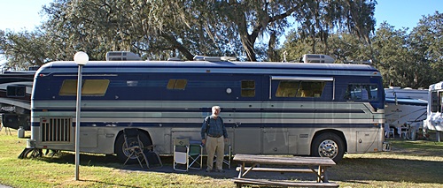
Al Hesselbart and his 1978 Newell.
We sat in the sun outside Al’s 1978 Newell and had a long, comfortable chat. We had skipped lunch, so by 4 PM we were hungry and Al suggested a Chinese Buffet in Brooksville, which was actually in Spring Hill. It had an incredible variety of food, some of which we could eat, and was in fact quite good. We dropped Al back at his coach and headed for home with a brief stop at the Ocala Publix for a few things.