(Photos at the end)
Today was day 1 of 4+ for our SKP Photographers BOF mini-rally and digital photography workshop. In the morning we got introduced to each other and then spent a couple of hours going over photography basics, with an emphasis on how digital SLRs deal with some of these issues through their available camera settings, and with a preview of the topic of image post-processing software and techniques. We wrapped up with a discussion of our afternoon/evening field trip and then broke for lunch around 11:15 AM.
We reconvened at 12:15 PM in our cars and headed out caravan style. We had four vehicles. Lou and Val Petkus took the “wagonmaster” (lead) position since they knew where we going. Linda and I took the “tailgunner” position (last in line) as we had a 2m amateur radio installed in the car and Lou had one installed in theirs. The other two cars had Family Radio Service (FRS) radios, but Linda and I did not, and Lou and Val left theirs at home. It allowed me to communicate to Lou if one of the intermediate vehicles signaled a need to pull over. I also allowed me to stay in touch with Lou in case we got separated, which in fact we did going through Maryville, TN. As with Knoxville the other day, the route appeared clear enough and easy enough on the map but we got separated from the group at a stop light and then missed a turn. We caught up with them shortly thereafter at a Pilot gas station. I don’t know why, but I have come to the conclusion that we apparently have difficulty reading highway signs in Tennessee.
Our destination was the Cherohala Skyway, which runs through the large tract of national forests immediately south of Smoky Mountain National Park. SMNP was where Lou originally planned for us to go on photo outings, which is why we are in an RV park 5 minutes from Cades Cove. Since SMNP remains closed due the idiocy of the United States Congress, Lou had to find alternative locations.
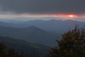
Although the eastern terminus of the Cherohala Skyway at Tellico Plains, Tennessee was 90 minutes from our encampment, it was a great choice for landscapes and worth the drive. It crosses the Appalachian Mountains into North Carolina, cresting at 5,300 ft. ASL before dropping back down below 2000 ft. ASL and ending at Robbinsville. The highest points are in North Carolina. We drove past them, but not all the way to Robbinsville, and then came back to Big Junction at 5,200 ft. ASL with a great view looking southwest across ridge after receding ridge of mountains and valleys.
We got there around 6 PM, got our cameras set up (on tripods with shutter releases, of course) and then had the “sack dinners” we brought along. We started looking for photo ops around 6:30 PM and were actively shooting from 6:45 until about 7:30 PM. Sunsets are not an easy subject, and you never know how they are going to progress. One of the mistakes a lot of people make is to quit shooting before it’s really over. The best shots often come a little time after you think there isn’t anything else to photograph.
We wrapped up at Big Junction around 8 PM and drove back to Townsend, TN in the dark, arriving at the Tremont Outdoor Resort a little before 10 PM.
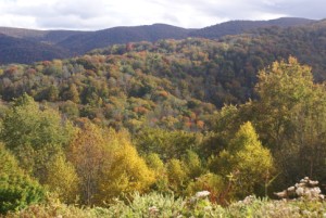
Cherohala Skyway.
Cherohala Skyway.
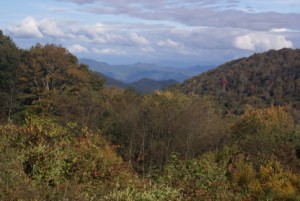
Big Junction, Cherohala Skyway.
Cherohala Skyway.
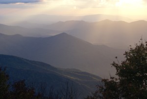
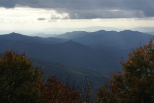
Big Junction, Cherohala Skyway (in NC looking west towards TN).
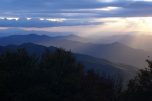
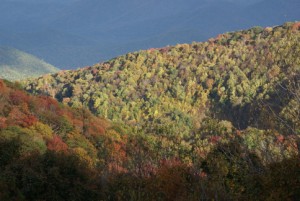
Big Junction, Cherohala Skyway.
Big Junction, Cherohala Skyway.
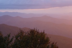
Setting sun from Big Junction overlook, Cherohala Skyway.
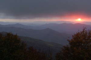
The final glow. Big Junction, Cherohala Skyway.