THURSDAY 04 August
Our W3W location at St. Barbe RV Park (NL) is “quirky.profiting.coverings”. We are at 51.202310 degrees (N) Latitude, -56.777957 degrees (W) Longitude. I wasn’t sure I had included this in my August 3 post. If I did, and it was different, that’s only due to where I was standing when I captured our location. The trailer has not moved since we got here.
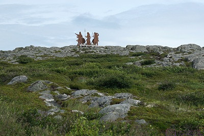
High on the hill above the parking lot were these sculptures of Norsemen looking to the west.
I was up at 6 AM to take my cold and flu medication (OTC), then cat, coffee, computer. I worked on blog posts but was not able to create them in WordPress as my computer was having trouble connecting to the RV Park Wi-Fi signal from within our trailer, even though our iPads seem to work OK. I can take my computer to the building this evening and work from there. Everything is ready, so it should go quickly.
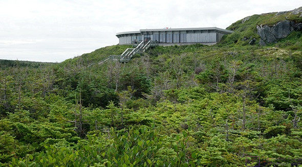
The Viking Settlement NHS Visitor Center.
Our objective for today was to visit the Viking Settlement National Historic Site (Parks Canada) in L’Anse aux Meadows, Newfoundland. The site is at the northern end of the western peninsula, but not quite the farthest point north on the island, which is the tip of one of the two peninsulas just west of L’Anse aux Meadows (towns of Cape Norman or Ship Cove). Even so, it was 145 km (~ 90 mi) north and east of our RV park.
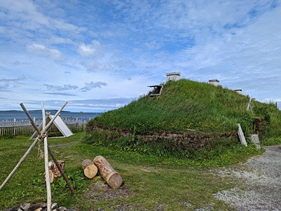
The longhouse, one of three reconstructed buildings on the site (photo by Linda).
Since we had pretty much scrubbed taking the ferry to Labrador, this was the farthest north we would travel in Newfoundland, and in Canada. Indeed, it’s the farthest north either us have ever been by land-based travel. Our map apps indicated ~ 1 hr 45 minutes driving time to get there, so we planned to leave at 8:15. That meant we had breakfast earlier than usual; toasted bagels and orange juice to get the day started.
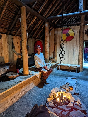
The costumed interpreter we encountered when we first entered the reconstructed longhouse. He explained the relationship between the four tales of Vinland and archeological reality. (Photo by Linda.)
Although Linda also started coming down with a cold last evening, she still felt better than I did, and suggested that she drive today. That sounded good to me. We had a heavy cloud layer but, unlike yesterday, a clear line of sight. Most of the trip was on Hwy-430 (The Viking Trail, of course), with the last 22 km on Hwy-435.
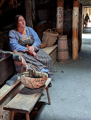
One of the two costumed interpreters we met in the reconstructed longhouse. She was knitting. (Photo by Linda.)
Hwy-430 hugged the west coast for a while before turning east and heading inland. As we got north of Flowers Cove, we noticed land across the water to our left (northwest). It was hazy, but it was definitely there, clearly visible well above the level of the ocean. Checking Google Maps, we eventually determined that it was Labrador, about 10 miles distant. We lost sight of Labrador when we turned east, but could see it clearly again once we reach the Viking Settlement NHS. (We cannot see Labrador or Blanc-Sablon, Quebec from St. Barbe, Newfoundland, as the mainland coastline curves towards the west, away from the island. In thinking about why the ferry takes travels a greater distance and take almost two hours to go between St. Barbe, NL and Blanc-Sablon, QC we reasoned that the two terminals must be deep water ports.)
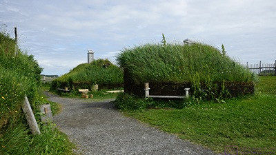
The two other reconstructed buildings.
The Viking Settlement NHS is an archeological site of historical significance. The four tales of Vinland describe how the Norsemen, who moved from the (now) European mainland (Scandinavia) and Hebrides Islands to (what is now) Iceland and then to (what is now) Greenland, continued their journey west and south, eventually finding what they called “Vinland.” (Interesting point, the correct term for these people, men and women, is Norsemen, and they were traders. The term Viking only applies when they are engaged in raiding. Only men were Vikings.) These tales, written long ago about events that took place almost 1,000 years ago, are part mythology, of course, but the presence of the Norse in Iceland and Greenland is historical fact. It was long suspected (or at least hoped by some people) that they were the first Europeans to set foot on (what is now) North America.
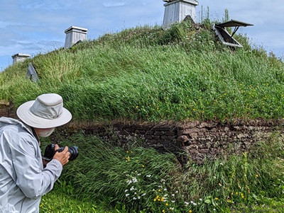
Bruce eyeing the sod construction at the corner of this reconstruction longhouse to see if there is an interesting photo opportunity. He took the photo, but it wasn’t that interesting after all. (Photo by Linda).
Based on the tales, a husband-and-wife team of archeologists searched for a place where the Norsemen might have had an encampment. Their search eventually led them to the L’Anse aux Meadows area of present-day Newfoundland. They questioned locals about the possible existence of “mounds” and were taken to “the old Indian camp.” Based on what they saw, which wasn’t much to the untrained and uninformed eye, they knew they had found something of potential importance. They conducted an archeological investigation from 1960 to 1967, and many locals helped with the work. The mounds were where buildings had once stood, but it was the discovery of artifacts, including iron, that finally provided the evidence that the Norsemen had been here, about 1,000 years ago.
A view of an island off the coast.
There’s more to the story, of course. The Norsemen almost certainly interacted with indigenous people while here, as the tales include mention of such encounters. Butternuts and butternut wood fragments were also found at the site. These came from present day New Brunswick, so the Vinland described in the tails extended well beyond present day Newfoundland and Labrador. The four tales of Vinland, even with the unavoidable changes that occur with oral history, apparently contained more than a grain of truth.
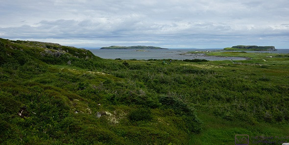
A more complete view of the cove at the Viking Settlement NHS.
Artifacts are displayed in cases in the Visitor Center while the archeological site is an easy walk away. Archeological sites are not usually very interesting to look at, in and of themselves, but we find them fascinating. You just have to be able and willing to think about where you are and what existed and happened there a long, long time ago. 1,000 years ago, people had traveled across the forbidding North Atlantic Ocean in small wooden boats with wool sails, made it to this exact spot, and established an encampment that lasted about 10 years. To help most of us visualize what life was like for these people, Parks Canada has also reconstructed part of the encampment adjacent to the archeological site, complete with costumed interpreters. They also offered guided tours, a feature we have seen, and enjoyed in other parks.
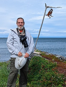
We came across this dragon on our walk at the NHS. Bruce isn’t Norse, but he was born in the year of the dragon, so there’s that. (Photo by Linda.)
But the real historical significance is something else. Described in a 15-minute film at the Visitor Center, Completing the Circle focuses on the fact that the encounter between Norsemen and Indigenous people at L’Anse aux Meadows completed the human migration out of Africa that began 100,000 years ago. Moving out of Africa, “modern” humans moved north into what is now Europe and east into what is now Asia. About 25,000 years ago, people from the Asian branch crossed a land bridge into what is now Alaska, and moved down through what is now The Americas (North, Central, and South). When the Norsemen met the Indigenous people on Newfoundland, it was the first time the branches of the African migration had met, and human beings had now encircled the planet Earth.
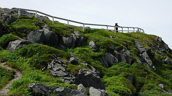
The trail we walked went up onto a cliff at this point. Linda is up, looking out over the ocean.
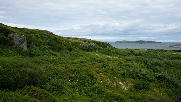
In addition to the archeology, the Viking Settlement NHS has 80 km2 of low, rocky hills covered in vegetation but almost devoid of trees; a very different landscape from what we have seen in Newfoundland up to this point, with a beauty all its own. A 2.4 km trail through the west portion of the grounds made for a lovely walk, with good views of the Labrador coast.
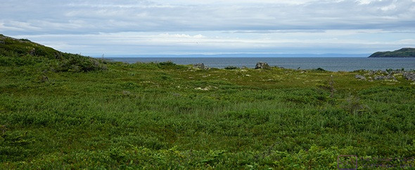
If you look closely, you can see Labrador.
As long as we had come this far, we drove to St. Anthony. One the way we passed “St. Brendan’s Motel” and stopped to take a picture. We had not done any research on this town, and found it quite unremarkable. The big things to see/do all involve a Dr. Grenfell; Museum and Property, etc. That did not interest us, so we did not bother trying to find them. We stopped at the Foodland store, and bought a loaf of bread, a box of tissues, a small box of granola bars, and Gatorade for me to drink. We then headed back to St. Barbe, stopping briefly at the PharmaCare in Flowers Cove for bottled water.
PHOTO – St-Bs-Motel We spell our son’s name this way, so we had to take a picture. Besides, it’s a colorful paint scheme. (Photo by Linda.)
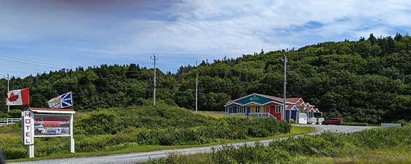
We spell our son’s name this way, so we had to take a picture. Besides, it’s a colorful paint scheme. (Photo by Linda.)
It had not been a hard day, but we were both feeling the effects of not being completely well. We had some hot tea and then Linda napped while I worked at my computer. Linda was going to make mushroom risotto for dinner, but it turned out that we did not have any rice on board. Mushroom pasta was the backup option, but the two containers of mushrooms had gone bad. We ended up having ramen and crackers. Again; simple, easy, and tasty.
After working on this blog post for awhile after dinner, I took my computer to the building and created the actual posts in WordPress. There were three rooms where I could work, one of which had a TV on. Another one had a table and chairs, so I worked there. There was only one other RV in the park, plus the park manager in the office, so the Wi-Fi was solid and fast, and the WordPress process was smooth and relatively quick. As long as I had a good Internet connection, and checked e-mail.
Back in the trailer, I plugged in our Western Digital Passport portable hard drive (USB) and backed up all of the work from the last few days.
When the day started, we still had a glimmer of hope about taking the ferry to Labrador (via Quebec) tomorrow. With both of us having developed colds, any chance of that was off the table. While a bit disappointed, we were glad that we at least got to see it from afar.
Although we don’t feel like we have been pushing ourselves overly hard, tomorrow will be a day of rest and light chores before we move the trailer again on Saturday. We have two more nights booked at the Gros Morne – Norris Point KOA, and then our journey takes us east across the island, ultimately reaching St. John’s before returning to Channel-Port-aux-Basques to take the Marine Atlantic ferry back to North Sydney, Nova Scotia.
…