WEDNESDAY 17 August
(There are 16 photos in this post, all having to do with the National Historic Site. The weather was heavy overcast with mist around the tops of the hills. The photos are the best I could do in these conditions.)
We both stayed in bed this morning until about 7 AM when I finally got up to feed the cat and make our morning coffee. Linda was up before the water had come to a boil. With the excellent Internet we have here, there’s no need to be up before the sun to get online. Breakfast was bagels. We had not yet formulated a plan for the day, beyond two things that I wanted to accomplish first thing.
Number one was finding out what I needed to do to get the oil changed in the F-150. To that end, I drove to Cabot Ford Lincoln on Kenmount Road, just a few miles from our campground. Kenmount Road turned out to be “auto dealer row,” along with “shopping road.” The Avalon Mall was there, as well as lots of small strip malls with all kinds of businesses, including food and drink establishments. I stopped at an Irving fuel station on the way and noticed a Blaze Pizza next door. We might have to go there while we are in town.
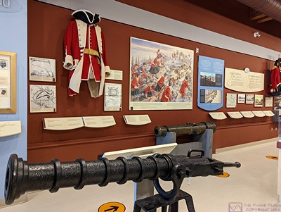
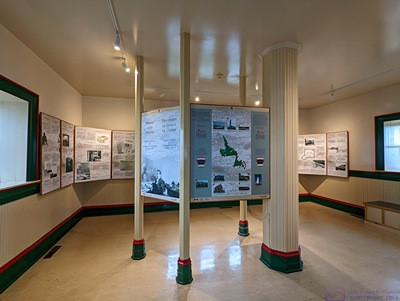
Part of the information display area of the Visitor Center at the Signal Hill National Historic Site in St. John’s, Newfoundland.
The Ford dealership was very nice. And, yes, I needed an appointment, so the service writer set me up for first thing Friday morning. While not “technically” necessary according to Ford’s service intervals, I’ve always figured that oil is the least expensive preventative maintenance I can do on an engine, and we’ve been pulling the trailer through mountainous terrain since beginning of July. It will be full synthetic plus an oil filter, of course. They will also rotate the tires and check the brakes. The rear tires are more worn than the front tires at this point, and checking the brakes is just prudent. Given our mileage to date, we will put more than 10,000 miles on the truck by the time we get home, and it will be time for another oil change.
Back at camp, I finally called Woodland Airstream and talked to Joyce, who coordinates service appointments and warranty claims. I was pleased to find that Erich, the service manager, had put me on the schedule to drop the trailer off on Monday, October 17 based on the conversations and text message we exchanged back in May. I need to send Joyce our list of repair issues so she can start to investigate warranty eligibility. I planned to do that this evening or tomorrow morning.
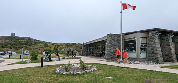
A view of the Signal Hill NHS Visitor Center looking ~SE (I think).
Linda had been checking the weather and considering our options for the day. It looked like the serious rain would not start until sometime after 5 PM. The Signal Hill National Historic Site was one of the things we wanted to do in the area. It was just on the north side of St. John’s Harbor, only 15 – 20 minutes away, and that’s where we decided to go. Another incredible Parks Canada site, Signal Hill NHS sits atop a hill on the north side of the entrance to the Narrows which leads into St. Johns Harbor. Like always, we started at the Visitor Center and learned that the hill stands 167 m (~543 ft) above the North Atlantic Ocean, and the location has a long and significant history for many reasons.
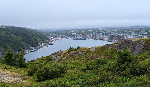
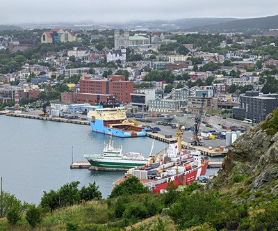
Our first view of St. John’s, Newfoundland, from the Visitor Center at the Signal Hill NHS.
The small building, upper left, is the Powder Magazine (reconstruction) for the Queen’s Battery located to its right behind the hill.
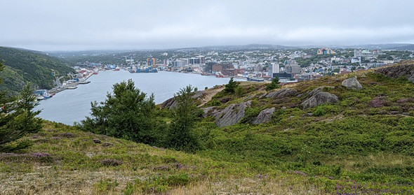
A view of St. John’s Harbor and Town from the trail leading to the Queen’s Battery.
First, it is believed that John Cabot’s (Giovanni Caboto) 1497 expedition, under the patronage of King Henry the VII of England, landed at this location on the far eastern shore of present-day Newfoundland. The more supported supposition is that the expedition made first landfall in what is now southern Labrador and then explored along the northern and eastern coast of Newfoundland before arriving at the entrance to St. John’s Harbor.
From Wikipedia ( en.wikipedia.org/wiki/John Cabot ): “To mark the celebration of the 500th anniversary of Cabot’s expedition, both the Canadian and British governments elected Cape Bonavista, Newfoundland as representing Cabot’s first landing site. However, alternative locations have also been proposed.” It is generally accepted that the men in Cabot’s expedition were the first Europeans to set foot in what is now North America since the Norse explorations of Vinland and the establishment of the Viking Settlement at L’Anse-aux-Meadows by Leif Erickson 500 years earlier. St. John’s has been inhabited ever since by people not of native origin, making it the longest continuously inhabited, and the easternmost, city in North America.
A wider view of St. John’s and the harbor from the Signal Hill NHS.
PHOTO – 300x398_Heather-at-SH-NHS … There was a wonderful variety of low vegetation at the site. This small, light purple, plant is common heather (Calluna vulgaris). (From Wikipedia, it “is the sole species in the genus Calluna in the flowering plant family Ericaceae.”) It was everywhere at this site, but this was the first place we have seen it during our travels.
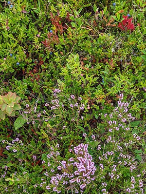
There was a wonderful variety of low vegetation at the site. This small, light purple, plant is common heather (Calluna vulgaris). (From Wikipedia, it “is the sole species in the genus Calluna in the flowering plant family Ericaceae.”) It was everywhere at this site, but this was the first place we have seen it during our travels.
But that was just the beginning. The waters off the east coast of Newfoundland were an incredibly rich fishery that ultimately drew the French and the English to these shores. The long periods of conflict between England and France were contested all over the globe, and St. John’s became one of those places in North America. Signal Hill occupied an incredibly strategic location and was eventually developed for military purposes to defend the Narrows leading into St. John’s Harbor. There was a matching fort on the hill on the south side of the Narrows. These two sites changed hands between the British and the French until the British finally prevailed, as they did elsewhere in North America.
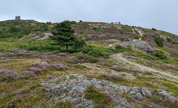
A view from trail looking up towards Cabot Tower (top-left) and the Powder Magazine (top-center/right). This was very representative of the appearance of the site as we climbed closer to the top of Signal Hill.
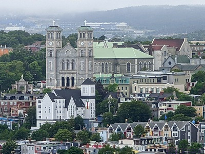
A view of the Basilica Cathedral of St. John the Baptist and surrounding Ecclesiastical District in St. John’s, Newfoundland, as seen from Signal Hill.
Once the territorial dispute was settled, Signal Hill developed as a location for signaling ships approaching the Narrows and signaling St. John’s about the arrival of such ships, and it is from this period that the location got its name. This signaling was done with flags, and Signal Hill is the site of the Cabot Tower, built between 1898 and 1900 to continue the port signaling service which originated in 1704; flag signaling continued from the deck of Cabot Tower until 1958.
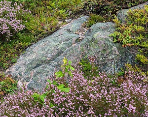
While the Signal Hill NHS offered plenty of “grand views,” my eye was offered pulled towards smaller details of the site, such as this rock surrounded by heather.
But something else historic took place here on December 12, 1901 when Guglielmo Marconi received the first transoceanic wireless signal from a station in Poldhu, Cornwall, England in a former military barracks on Signal Hill.
The site saw a resumption of military activity during WWI, but became a significant site once again during WWII as St. John’s was the final staging area for the merchant marine convoys and their naval escorts departing for England. These convoys, along with trans-Atlantic aviation, were the supply lines that made the Allied presence in Europe possible.
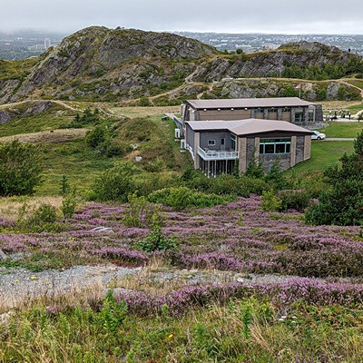
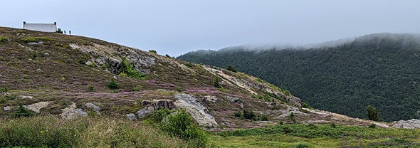
This view of the Signal Hill NHS Visitor Center, looking west from above on the trail, gives a context to its location.
The communications capabilities in place at Signal Hill by that time played a major support role in the Battle of the Atlantic. From Wikipedia: “The Battle of the Atlantic, the longest continuous military campaign in World War II, ran from 1939 to the defeat of Nazi Germany in 1945, covering a major part of the naval history of World War II.”
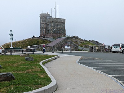
The approach to Cabot Tower from the parking lot. My particular interest in this site and tower was its role in communications; first, signaling with flags, and then, its historic role in the first wireless (RF) trans-Atlantic communication. Marconi was here (as the saying goes). The Tower has two floors and a roof deck, all open to the public. The first floor is a gift shop and the second floor is an information display on Marconi and wireless communications. It was this room where Marconi actually had equipment set up. An amateur radio station is located here.
As a Canadian National Historic Site, all of this history is available to visitors, and the parking lots at the Visitor Center and Cabot Tower were crowded on this Wednesday in August. But there are also lots of hiking trails, and some of the best views of St. John’s and its harbor. We bought several T-shirts in the Cabo Tower gift shop. (An unusual purchase for me, to be sure, but they had one that I liked.)
The amateur radio (ham) station in one corner of the 2nd floor of Cabot Tower. A local amateur radio club maintains and operates this station and a display case contained some of their QSL cards.
When we were done at Signal Hill, we drove around to Quidi Vidi just to the north. It was a charming little enclave reached on narrow, twisting, steep roads. The main area had lots of food trucks and what looked like a festival green, but there was no obvious place to park, and lots of “no parking” signs. We are always a little puzzled by places like this that seem to want to be a tourist destination, but lack the ability to accommodate tourists. It was drive-through experience for us.
The information display on the 2nd floor of the Cabot Tower. This room originally held Marconi’s wireless communication equipment and operator stations.
Both Signal Hill and Quidi Vidi were north and east of our RV park, so one of them (probably Quidi Vidi) was now the farthest east we have traveled, but I did not capture GPS coordinates. The farthest east point of land in all of North America is Cape Speer, again north and east of our RV park. It’s a bit farther than we ventured today, about 15 miles, and we plan to make it there before we leave the area next Monday.
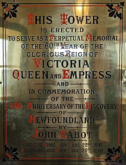
This plaque, in the entrance to the Cabot Tower, marks the 500th anniversary of John Cabot’s discovery of Newfoundland and the 60th year of Queen Victoria’s reign.
Before returning to Pippy Park, we meandered through St. John’s without the aid of the electronic navigation, eventually reaching Kenmount Road where I started my day at the Cabot Ford Lincoln dealership. I wanted Linda to see what was available in this area in terms of any shopping we might want/need to do. A quick search located a Sobeys nearby, but not on Kenmount Road. To get back to camp, I wanted to take Prince Philip Dr. as it passes through the main Memorial University campus. I missed the turn, if a turn was even possible. Elizabeth Avenue was my back up plan (that’s how I came back from the Ford dealership this morning. I missed that turn as well, so our route ended up being Freshwater Rd. to Empire Ave. to Allendale Ave. and then Nagle’s Pl. and the entrance to the campground. It was actually nice to miss turns and not have to worry about. When towing the trailer (or driving the bus with the car behind it) missing turns is a BIG DEAL.
PHOTO – 590x533_NL-as-cntr-world … I really liked this graphic on an information board outside of Cabot Tower. (I altered the colors to make the water light blue and the land a slight tan.) It shows St. John’s, Newfoundland at the center of the largest circle, with concentric circles going out from there. Just above the center is the North Pole. Meridians radiate out from there and it is encircled by lines of latitude. It was a unique way to visualize Newfoundland & Labrador’s “place” in the world.
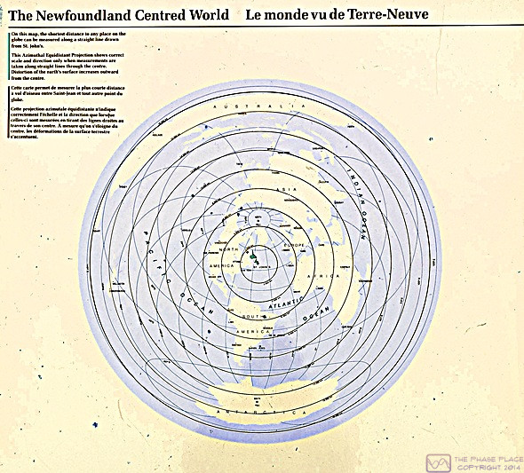
I really liked this graphic on an information board outside of Cabot Tower. (I altered the colors to make the water light blue and the land a slight tan.) It shows St. John’s, Newfoundland at the center of the largest circle, with concentric circles going out from there. Just above the center is the North Pole. Meridians radiate out from there and it is encircled by lines of latitude. It was a unique way to visualize Newfoundland & Labrador’s “place” in the world.
We were back at our trailer by 4:30 PM and ready for dinner, so Linda heated up the leftovers from last night. They were just as good the second time around. We had the two oranges from the restaurant for dessert. Early evening, we started to get a light, intermittent drizzle but it eventually turned into a full-on rain event. Not a storm as such (no lightning or thunder), although the government weather service said a thunderstorm was possible after midnight. It was not a torrential downpour, but a total accumulation of 10 – 20 mm (0.4 to 0.8 in) was expected by morning. Eastern Canada, in general, and Newfoundland, in particular, really needs rain and this system looked to produce quite a bit over a large portion of the island over the next few days. We will adjust our outings accordingly.
Linda read most of the evening while I worked at my computer. I shot 105 photos on my Pixel 6 Pro today, so I had a bit larger task than usual selecting ones for this post and processing them. Later in the evening we popped a bag of Smart Pop microwave popcorn.
…