SUNDAY 04 September
(This post has 16 photos.)
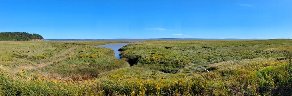
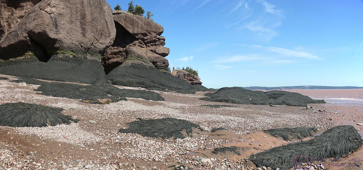
A panoramic view of the salt marsh at the east end of Ponderosa Pines Campground. Mud-flats are beyond the marsh and extensive. The water is Chignecto Bay (Bay of Fundy); North Atlantic Ocean far to the right; Petitcodiac River and Moncton, NB “upstream” to the left. The headland to the far left is Hopewell Rocks Provincial Park. If you know where to look , the two south-facing overlooks and the picnic pavilion are just visible. (This photo is 1198×396 pixels. Click to view full-resolution.)
.
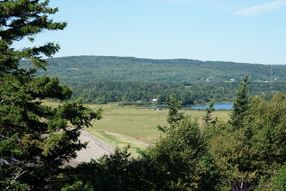
We could see the headland at the southern end of Hopewell Rocks Park from our campground. It stood to reason that we could also see the campground from these vantage points.
I got to bed late again last night (naps tend to do that to me) but did not get up until 7:45 this morning. The temperature dropped to 53 (F) overnight, but I was much more comfortable sleeping compared to the night before. Linda had suggested I put the small throw pillow from my bed between my head/shoulders and the wall, so perhaps that helped. She was awake and up shortly after me. We both got a good night’s sleep, which we needed.
our first experience with the Hopewell Cape area was yesterday when we walked to the east end of the campground after we finished setting up camp and had linner. From there we had a sweeping view of an extensive marsh, which had not yet been inundated by the incoming tide, and some muddy ravines that obviously filled with water when the tide was in. Our first two viewpoints today were looking south over the same salt marsh and the extensive Daniel Mud-Flats. Neither of these features were present at Burntcoat Head / Park, so Hopewell Rocks Park was clearly going to be a different experience.
.
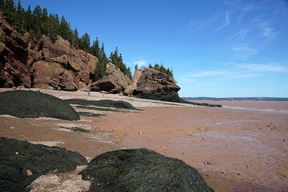
A closer look at the Daniel Mud-Flats, with Grindstone Island on the horizon, upper left.
I switched zone 2 from the heat-pump to the furnace for a few minutes to heat the belly of the trailer and take the chill out of the floor, and put the zone 1 (bedroom) heat-pump in fan mode to circulate some air. Once the furnace cycled off, I shut off zone 2, put the zone 1 heat-pump in heat mode, and set the thermostat up high enough for it to run. When it was finally warm enough in the living room, I shut off zone 1 as well.
We had a nice weather day on tap, which started with a bright morning sun bathing our trailer in light and warmth. Even with the outside air temperature still below 60 (F), we opened the door. Juniper-the-cat likes to sit there where she can see, hear, smell the outside world. She probably dreams of going out and exploring, but has never tried to “escape” from the trailer.
.
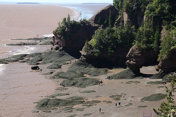
Formations that end up surrounded by water at high tide, but protrude above it, are called “flower pots.” (This is what the staff person at Burntcoat call the island, but these were not a prominent feature of that site.) At Hopewell Rocks Park, they are one of the main attractions, along with shear rock cliffs. We were also impressed by the abundance of “dead man’s fingers” seaweed, which covered almost every rock surface up to the high tide mark. It had the appearance of a long, tangled head of hair on something that might have been in the Pirates of the Caribbean films. Note how small the people on the ocean floor appear. The rock cliffs and formations are huge.
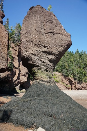
A flower pot with a seaweed encrusted base. In spite of the obvious and ongoing erosion, a display board indicated that the Park should continue to look much as it does today for at least another 100,000 years. That meant we could plan a return visit and it would still be here.
We planned to visit Hopewell Rocks Provincial Park today. Linda checked the tide chart, and low tide would occur at 1:06 PM, so planned to be there around 11 AM. The Park is adjacent to the north side of our campground and only a one mile drive to the entrance. There’s also a 1.7 km (~1 mi) trail from the east end of the campground to the Provincial Park parking lot, but we drove over.
The park is open from 8 AM to 6 PM, irrespective of what the tide is doing, so we would not get to experience a high tide there today. But we could see Chignecto Bay from our campground, so we could walk to the east end of the campground around 7:15 PM to catch the high tide at 7:19 PM if we were so inclined.
.
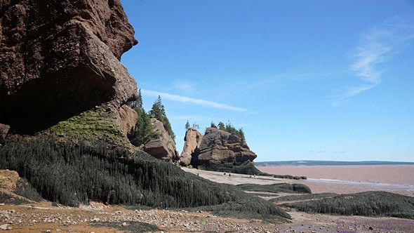
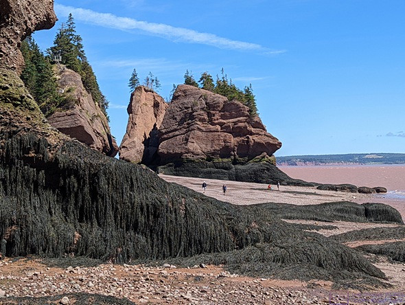
Big rocks and thick seaweed. The entire shoreline of Hopewell Rocks Provincial Park looks like this. The formations are huge.
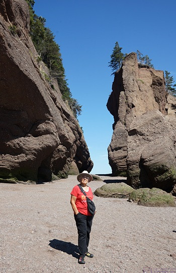
A young woman is standing with her back to the camera just to the left of the “small” pointed rock in the middle of the photo. She provides the sense of scale needed to understand the size of these rock formations.
We had egg sandwiches and fresh fruit for breakfast at 9 AM. Showers were the order of the day following breakfast. We tidied up the trailer, got the camera, left for the park just before 11 AM, and pulled in a few minutes later.
The entrance sign said it’s a New Brunswick Provincial Park, but it’s not. It’s run by the Provincial Parks, but is considered an “Attraction.” The large parking lot already had quite a few vehicles, but was far from full. We paid for our admission at the entrance booths, good for today and tomorrow. The staffer at the entrance booth said they are trying to gain Provincial Park status. It was a short walk from there to the main building, which housed a gift shop, information center, restaurant, and the all-important restrooms.
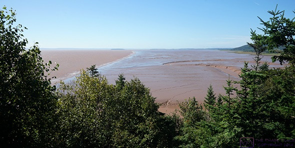
The first two viewpoints were not far from the main building and faced south overlooking the extensive Daniel Mud-Flats and salt marsh on the west bank of the Bay. From there, it was an 800 m (~1/2 mile) walk on a wide gravel path through the woods to the “99 steps” that go down to the ocean floor. There was one short, but steep, side path to a third viewpoint.
This is a composite image of three photos. It’s 1198×562 pixels, and should be viewable at full-resolution by clicking on it. The dark green stuff covering many of the low rocks is “dead man’s fingers” seaweed.
.
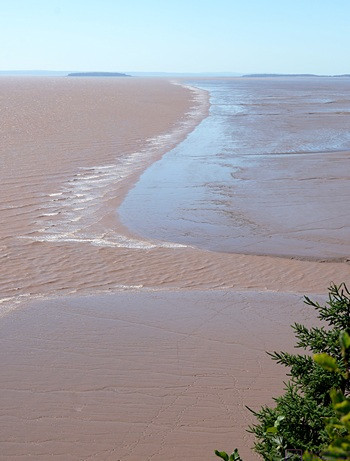
It was past low tide and we were headed back to the staircase when I took this photo. The ocean floor here has a very gentle slope as it first emerges from the water at low tide, and then has a steeper slope as it rises to meet the base of the cliffs. As soon as the tide switches and starts coming in, the water moves horizontally towards the cliffs very quickly at first.
.
Linda on the ocean floor at Hopewell Rocks Park. She is closer to the camera than she is to the rocks, and the lens is set to 28 mm, so the perspective is distorted and she appears taller relative to the rocks than is actually the case.
The main staircase was impressive in its own right. It was a solidly built and anchored steel structure, with landings between flights of stairs. It had two “sides,” one labeled “Down Only” and one labeled “Up Only.” (We were immediately reminded of the movie “Up The Down Staircase.”)
When we finally got a view of the ocean floor, we understood why this structure existed; there were hundreds of people down there, and almost all of them had to go down these stairs and come back up them eventually. (There was also handicapable access to the ocean floor at the north end of the Park, which as its own parking lot.) But the park has a long shoreline, and people were spread out, so it did not look or feel crowded.
.
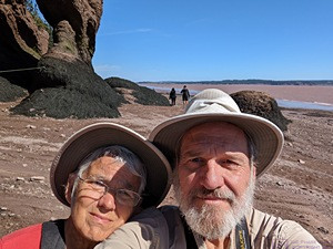
Us the ocean floor at Hopewell Rocks Provincial Park in New Brunswick. (Camera pointing south with the sun behind us.)
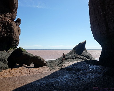
The Bay of Fundy and Ocean Floor experience here was different from Burntcoat Head / Park. The Rocks here were more numerous, higher and dramatic, and there was plenty of drier places to walk in the upper half of the tidal range, but we had less access to the water. There was also an absence of visible life in the tide pools, and no warnings to avoid them. But we did not venture down to the water’s edge as we did not want to get our sandals muddy this time. The only real warning was to stay out of the mud-flats and not slip and slide on the mud in the areas where you could walk. There were also a lot of small coves that were roped off with warning signs about the danger of rock falls. There was plenty of evidence of rocks cleaving off from the cliffs, and some of them where many times larger than a pickup truck.
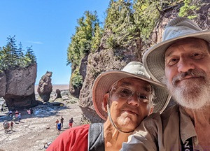
Us again, this time with the camera pointing north, so we are facing the sun. Same faces, different rocks.
We ate lunch at the on-site counter-service restaurant around 2 PM. They had a nice salad on the menu, but it was sold out it (there must have been other vegans there ahead of us.). We split a veggie wrap and an order of onion rings instead. We sat outside at a shaded table because it was such a nice day, and because a young child inside was very unhappy about something and making sure everyone (except the parents, apparently) knew about it.
After lunch, we spent time in the information center. The displays were very informative and we read all of them. From there we visited the gift shop and picked up a couple of post cards and a couple of other little things. When we returned to our truck around 3:30 PM, the parking lot was much fuller than when we had arrived, but still not at capacity. Based on the park map, there was space for over 300 vehicles, including a dozen or more buses. My WAG was 800 to 1,000 people in the park by the time we left.
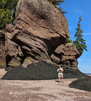
Bruce standing next to a large flower pot formation. (Photo by Linda.)
Back at camp, we made coffee (we didn’t have our second cups this morning) and sat outside to use our iPads. I had a good enough Wi-Fi/Internet connection that to use Feedly, so I caught up on reading the latest posts from the blogs I follow. When it was finally too cool to sit outside without a jacket, we retreated to the trailer, where I started up my computer, transferred photos from the camera, and started looking through them.
We had dinner around 6:45 PM, a bit later than usual owing to our slightly later lunch at the park. Linda improvised a sauteed vegetable dish with potatoes, carrots, onions, garlic, green beans, shitake mushrooms, black pepper, and red chili pepper flakes. It was very tasty, and had a bit of “heat.”
.
Seaweed and large rock formations were the defining features of the shore at low tide. Hopewell Rocks Provincial Park, New Brunswick. (Photo by Linda.)
.
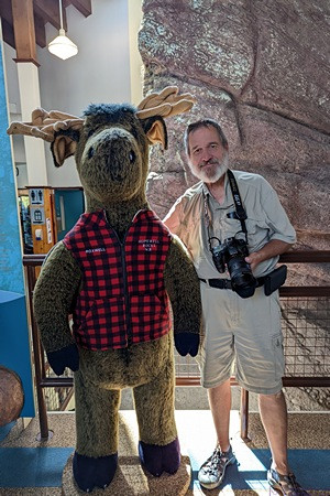
Bruce poses with the Moose in the Hopewell Rocks Park Visitor Information Center. (Photo by Linda.)
After dinner we went for a stroll in the campground to “get our blood circulating” and to check out the laundry room. We had three more days at this campground to explore the area and two main things we want/need to do. One was visit Funday National Park (Parks Canada) just south of here, and the other was take care of a few essential chores, including laundry and a trip into Moncton for groceries and fuel.
The current forecast showed good weather for all three days. Rather than leave errands until the last minute, we decided we would take care of those tomorrow and visit the National Park on Tuesday. That would leave Wednesday for a return visit, or a chance to just relax (and work on blog posts).
We read and worked puzzles for a while after our walk. By 10 PM it was very cool, so we closed down most of the windows and turned down our beds. Linda climbed in, followed by the cat, as that is her usual bedtime, while I returned to processing photos from today and started writing this post. It rained briefly, and there was a low chance of rain during the overnight hours. The low temperature was forecasted to be 58 degrees (F). I set the zone 2 heat-pump to 60 (F), but did not expect it run much, if at all.
…