Tag Archives: Townsend (TN)

2013_10_15 (T) Image Post-Processing

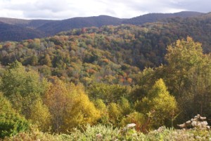
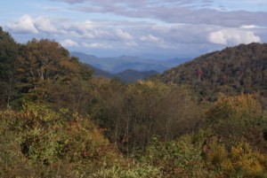
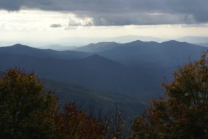
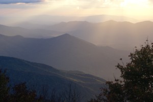
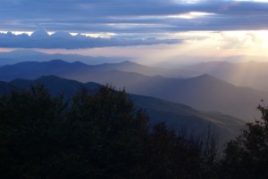
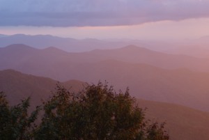
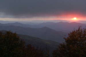
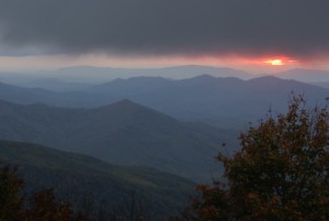
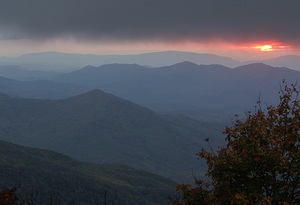
(At the end of this blog are the same 10 images I posted yesterday, only this time with image post-processing.  There is also a new image that I created today.)

The photography workshop today was mostly classroom work.  We spent the morning seeing several image post-processing programs demonstrated and discussing their functions.  The featured programs were Faststone Image Viewer and Photoscape, both of which are free downloads.  Each of the five workshop participants contributed a few pictures from yesterday and Lou, the workshop presenter, used them as examples to demonstrate the use of the image editors.  Most of us were new to this sort of image manipulation, so the focus was on understanding the image histogram, adjusting levels, adjusting “lighting” (highlights, shadows, contrast, and saturation), sharpening, cropping, and resizing.

After lunch Sue Wharton, one of the participants, demonstrated and discussed Adobe Photoshop Elements, which can be purchased for a moderate price.  Sue has used versions of Elements, all the way back to the very first one, to organize her photographs.  She emphasized that Elements will do everything we saw demonstrated in Faststone Image Viewer and Photoscape, but demonstrated some additional features that the free programs did not have.

We also discussed Adobe Photoshop and Adobe Lightroom.  Photoshop is generally considered the ultimate photographic image editing tool, but it is a considerably more expensive program with a steep learning curve.  We were told that Lightroom, which is also not free, was the number one choice of professional photographers for managing their collections of digital images.  As of this writing I am not completely clear on the just what each of these programs does or how they (should) fit together, but the general consensus was that Lightroom is the ultimate “front end” image organizer, below which you need an image editing program or programs, which is most of what we saw demonstrated today.  Adobe Elements, however, is a very acceptable all-in-one solution to both the organizing and editing tasks.  Another program we discussed, but did have demonstrated, was Topaz Photoshop Plug-ins, along with iView (and irfinview), which are needed for the standalone use of Topaz plug-ins if you don’t have Photoshop or Photoshop Elements.

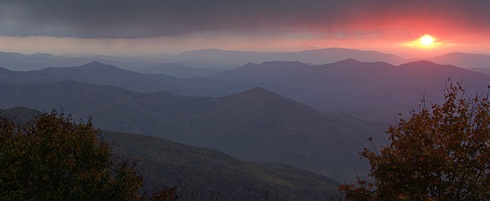
The last thing we discussed was how to create panoramic photographs using a two part process.  Part 1 was setting up the camera properly on a tripod and adjusting it so you could take a sequence of overlapping photographs as you pan across the scene.  Part 2 was using special programs or plug-ins to create a single composite image from the multiple photographs.  Lou demonstrated the use of a special panoramic camera mount that allowed the “nodal point” of the lens to be positioned at the exact center of rotation.  While this is slightly less critical than back in the film camera days, setting the camera up properly for panoramic shots still leads to better compositing in part 2.  One of Lou’s favorite tools for creating composite images is Microsoft Image Composite Editor (ICE) available as a free download from Microsoft.  He demonstrated how it works using some properly taken photographs he already had on hand.

After a mid-afternoon break, we headed to the Visitor Center in Townsend.  Everyone came, including a couple of spouses who are not participating in the actual workshop, so we first spent a little time in the Visitor Center gift shop.  The back parking lot had an unobstructed view of low hills with some middle and foreground elements that provided the opportunity to shoot up to a 180 degree panorama.  It was not a spectacular landscape, and the sky was cloudy to overcast, but it was an excellent spot for learning how to do this technique.  It had the further advantage of being close to both the Tremont Outdoor Resort, where we are all staying, and the restaurant where we planned to have dinner.

We all set up our tripods, leveled them (and our cameras), and went to work.  I first did a test shot in the center of the scene to determine the correct exposure.  Once I had that, I set the camera to Manual and locked that exposure in.  (That may not sound like a big deal, but I had only figured out how to do this within the last 24 hours, even though we have had the Sony Alpha 100 for years.)  I also set the camera to manual focus and adjusted it the way I wanted.  It is critical that both of these functions be set to manual; if the exposure or focus changes from shot to shot, the compositing software may not be able to stitch the images together, either satisfactorily or perhaps at all.  With the anti-shake feature off, and using a remote (cable) release, I shot a full 180 degree panorama with a moderate telephoto lens, taking 16 photographs to do it.

We went to dinner at a local Bar-B-Que restaurant on the river.  Linda had checked the menu in advance and packaged a blend of toppings that we could put on a salad consisting of lettuce and tomatoes.  Our salads ended up having beans, broccoli, onions, dried fruit, and peanuts (and probably a couple of other things).  Being as it was dinner out, I got small orders of French fries and onion rings.  The food was OK for the price.

After dinner Vince and I headed back to the classroom where Lou helped us stitch together our composite panoramas.  I finally got back to our coach around 8 PM.  Linda and I then worked on post-processing the images from yesterday’s blog post using what we had learned today.  And here they…I hope you enjoy them.


20131014x00116(2)

2013104x00121(2)

20131014x00135(2)

20131014x00144(2)

20131014x00153(2)

20131014x00155(2)

20131014x00165(2)

20131014x00175(2)


20131014x00179(2)

Townsend TN Visitor Center - 180 deg panoramic composite of 16 photographs.

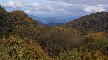
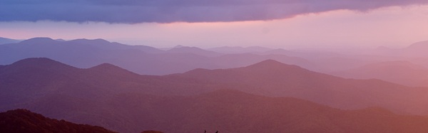
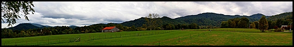
Townsend TN Visitor Center – 180 deg panoramic composite of 16 photographs.

2013_10_14 (M) The Cherohala Skyway

(Photos at the end)

Today was day 1 of 4+ for our SKP Photographers BOF mini-rally and digital photography workshop.  In the morning we got introduced to each other and then spent a couple of hours going over photography basics, with an emphasis on how digital SLRs deal with some of these issues through their available camera settings, and with a preview of the topic of image post-processing software and techniques.  We wrapped up with a discussion of our afternoon/evening field trip and then broke for lunch around 11:15 AM.

We reconvened at 12:15 PM in our cars and headed out caravan style.  We had four vehicles.  Lou and Val Petkus took the “wagonmaster” (lead) position since they knew where we going.  Linda and I took the “tailgunner” position (last in line) as we had a 2m amateur radio installed in the car and Lou had one installed in theirs. The other two cars had Family Radio Service (FRS) radios, but Linda and I did not, and Lou and Val left theirs at home.  It allowed me to communicate to Lou if one of the intermediate vehicles signaled a need to pull over.  I also allowed me to stay in touch with Lou in case we got separated, which in fact we did going through Maryville, TN.  As with Knoxville the other day, the route appeared clear enough and easy enough on the map but we got separated from the group at a stop light and then missed a turn.  We caught up with them shortly thereafter at a Pilot gas station.  I don’t know why, but I have come to the conclusion that we apparently have difficulty reading highway signs in Tennessee.

Our destination was the Cherohala Skyway, which runs through the large tract of national forests immediately south of Smoky Mountain National Park.  SMNP was where Lou originally planned for us to go on photo outings, which is why we are in an RV park 5 minutes from Cades Cove.  Since SMNP remains closed due the idiocy of the United States Congress, Lou had to find alternative locations.

Although the eastern terminus of the Cherohala Skyway at Tellico Plains, Tennessee was 90 minutes from our encampment, it was a great choice for landscapes and worth the drive.  It crosses the Appalachian Mountains into North Carolina, cresting at 5,300 ft. ASL before dropping back down below 2000 ft. ASL and ending at Robbinsville.  The highest points are in North Carolina.  We drove past them, but not all the way to Robbinsville, and then came back to Big Junction at 5,200 ft. ASL with a great view looking southwest across ridge after receding ridge of mountains and valleys.

We got there around 6 PM, got our cameras set up (on tripods with shutter releases, of course) and then had the “sack dinners” we brought along.  We started looking for photo ops around 6:30 PM and were actively shooting from 6:45 until about 7:30 PM.  Sunsets are not an easy subject, and you never know how they are going to progress.  One of the mistakes a lot of people make is to quit shooting before it’s really over.  The best shots often come a little time after you think there isn’t anything else to photograph.

We wrapped up at Big Junction around 8 PM and drove back to Townsend, TN in the dark, arriving at the Tremont Outdoor Resort a little before 10 PM.

Cherohala Skyway.

Cherohala Skyway.

Cherohala Skyway.

Cherohala Skyway.

Big Junction, Cherohala Skyway.

Big Junction, Cherohala Skyway.

Cherohala Skyway.

Cherohala Skyway.

Big Junction, Cherohala Skyway (in NC looking west towards TN).

Big Junction, Cherohala Skyway (in NC looking west towards TN).

Big Junction, Cherohala Skyway.

Big Junction, Cherohala Skyway.

Big Junction, Cherohala Skyway.

Big Junction, Cherohala Skyway.

Setting sun from Big Junction overlook, Cherohala Skyway.

Setting sun from Big Junction overlook, Cherohala Skyway.

The final glow.  Big Junction, Cherohala Skyway.

The final glow. Big Junction, Cherohala Skyway.


2013_10_13 (N) A Fork In The Road

We spent a quiet night with only an occasional car passing by.  Someone nearby must have a pack of dogs and fed them around 6 AM as I heard them howling in the distance.  At first I thought they were coyotes, but it wasn’t the right kind of howl.  We finally got up around 8 AM to cool temperatures and light fog.  I checked the house batteries state of charge (I really need to get the Magnum ME-ARC remote panel installed up in the house) and it was 71%, not bad for having powered the coach for 8 hours.

Sunrise at Acres of Land near Richmond, KY

Sunrise at Acres of Land near Richmond, KY

A nice sunrise lit up the bedroom and by 9 AM the fog had burned off as we ate our breakfast of Linda’s homemade granola with fresh bananas, orange juice, and a cup of coffee.  This morning’s coffee was the Breakfast Blend from World Markets that Kathy brought to our open house.  It was delicious and already ground.  We generally grind our coffee beans, but it’s always nice to have ground coffee on hand, especially when we only want to make a couple of cups.

We had 186 miles to travel today, and check-in time at Tremont Outdoor Resort was 1 PM, so we targeted 10 AM as our departure time.  We left a little after 10 and took KY-876 east back to I-75 and continued south towards Tennessee.  Just after crossing the border we started down a long, steep grade but had to come to a complete stop before reaching the bottom.  We sat still, or moved along very slowly, while police cars, ambulances, fire trucks, and emergency management vehicles sped past us on the right shoulder.  We eventually had to move to left as the accident was in the right lane, and got the ire of an SUV who apparently felt we had cut them off.  Sorry.  It was an accident scene everyone in the right lane had to move to the left.  Here’s a tip for folks driving cars: when a semi or large RV puts on its turn signal, you might want to consider letting them move over.  These are large, slow vehicles and they need your cooperation to operate safely.

When we reached the accident scene there were two motorhomes on the side of the road, one with a towed vehicle that had the driver’s side smashed in, and a small white car that had been rear-ended and squashed pretty bad.  We tried to move through the accident zone as quickly as traffic allowed, but were not able in that short span of time to surmise just what had happened, other than something bad.

The rest of the trip to Knoxville was uneventful although traffic was heavier as cars and trucks cleared the accident scene and tried to make up for lost time.  We finally left  I-75, picking up I-275 through the city to where it was supposed to join up with I-40, which we thought we would take west and shortly thereafter pick up US-129 headed south towards Maryville.  That was the plan.  Remember plans from a recent post?  The Knoxville highway system is complex, and we were following the directions on our Rand-McNally RVND 7710 GPS while Linda double checked what we were doing on her Samsung Galaxy III smartphone.  Everything was fine until we came to a literal fork in the road and the GPS failed to tell us which way to go.  Intuitively we needed to go to the right, but that exit sign said “Downtown” and that didn’t seem right so we took the exit to the left and ended up…downtown.  Not just downtown, but on a very steep hill going up where we had to stop at a red light.  I don’t know what the grade of this hill was, but the bus was barely able to get moving from a dead stop.

On the plus side, while we were stopped there, a man crossed the street wearing a nice suit and bow tie and smiled and waved to us.  Also on the plus side, Sunday afternoon traffic was very light, so we didn’t have any further difficulties driving the 1.8 miles through the University of Tennessee campus back over to US-129 southbound.

At that point we were back on plan.  Just north of Maryville we picked up TN-35 which links up with the E Lamar Alexander Parkway, US-321 / TN-73 eastbound, which continued on as TN-73 and took us to Townsend.  Although the road got narrow and twisty in places, it was a pleasant and pretty drive.  All told, the accident scene and the Knoxville sight-seeing delayed our arrival at the Tremont Outdoor Resort by about 45 minutes from what the GPS originally predicted and we pulled in around 2:30 PM.

We turned off of TN-73 and crossed a bridge over a small river to enter the resort, at which point the GPS alerted us that we exceeded the weight limit of the bridge.  There were no weight limits posted  on this bridge, so we are not sure what that was all about.  We pulled up to the check-in area, scraping the top of the coach with the low over hanging branches that they assured us on the phone they did not have, and Linda went in to take care of the paperwork.  I could see from the driver’s seat that the roads in this RV park were not generous and might be problem.  When she returned with the map we unhooked the car and drove the route they wanted us to take to our site.  Right.  There were trucks parked where they shouldn’t be, and a maintenance golf cart by the restrooms that block part of the road.  I backed up and took the left fork in the entrance road, pulled up the tag axle, and made the hard left in sections B & C of the park.  From there I made a hard right, scratching the passenger side of the coach on some low pine/fir branches, finally got lined up, and back down into our section and into site B3.

The reason I mention all of this is that when we call to make a reservation we are very, very specific with people about the size and weight of our coach and specifically ask about overhead obstructions such as tree limbs.  (We always call, never book online, because of this.)  People consistently tell us that “you won’t have any problem” and it is, quite frankly either an ignorant response (they have no idea if we will have a problem or not) or they just plain lie about it.  I am also convinced that when we tell them we are 8.5 feet wide, 40 feet long (closer to 60 feet with the car in tow), 13 ft 2 inches tall, and weigh about 41,000 pounds those are just numbers that don’t mean anything to them.

But we got parked, leveled the coach, shut down the engine, and “made camp.”  I pulled out our Kenwood TH-F6 HTs (small hand held ham radios known as handi-talkies) and gave Lou, K9LU, a call on the previously agreed frequency of 146.550 MHz.  He was monitoring the frequency and came right back to my call.  Lou is the founder of the SKP Photographers BOF, and the organizer of the photography workshop we are here to participate in.  We went for a stroll around the RV park, as we usually do when we first arrive, and eventually made our way to Lou and Val’s 5th wheel where we had a nice chat.

We skipped lunch today, so Linda started dinner preparations when we got back to the coach.  She improvised a dish of diced potatoes, tomatoes, mushrooms, onion, and garlic, seasoned with basil and pan fried in a little bit of olive oil.  She served it with a side of broccoli and glass of red wine.  A couple of hours later we had some more of the wonderful blackberry pie we bought on the Fulton Farm Market on Friday.  I will be sorry to see the end of that pie, it really has been that good.

Since we are here for a digital photography workshop, I presume we will have more photographs to post over the next few days, but not today.